

Nana Continuing Westward and Expected to Become a Hurricane Tonight
NHC UPDATE SUMMARY OF 10:00 AM CDT INFORMATION
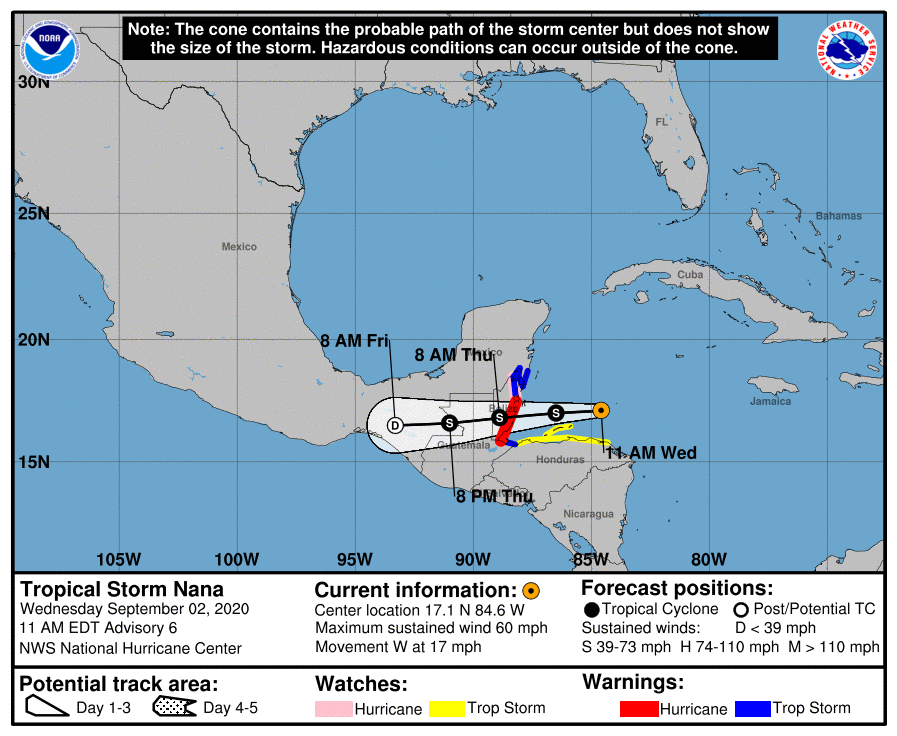
LOCATION: 240 miles east of Belize City
MAXIMUM WINDS: 60 mph
MOVEMENT: west at 17 MPH
MINIMUM PRESSURE: 998 MB or 29.47 in
WATCHES AND WARNINGS
A Hurricane Warning is in effect for…
* The coast of Belize from Belize City southward to the Belize-Guatemala border.
A Hurricane Watch is in effect for…
* The coast of Belize north of Belize city to the Belize-Mexico border
A Tropical Storm Warning is in effect for…
* Yucatan Mexico from Puerto Costa Maya to Chetumal
* The coast of Belize north of Belize city to the Belize-Mexico border
* Caribbean Sea coast of Guatemala
A Tropical Storm Watch is in effect for…
* Northern coast of Honduras from Punta Patuca westward to the Guatemala border
* Isla Roatan and the Bay Islands of Honduras
DISCUSSION AND OUTLOOK
At 1100 AM EDT (1500 UTC), the center of Tropical Storm Nana was located near latitude 17.1 North, longitude 84.6 West. Nana is moving toward the west near 17 mph (28 km/h), and this general motion with some decrease in forward speed is expected today. A westward or west-southwestward motion is expected tonight and Thursday. On the forecast track, Nana will be moving near but north of the coast of Honduras today, and the center should make landfall on the coast of Belize tonight or early Thursday.
Maximum sustained winds are near 60 mph (95 km/h) with higher gusts. Strengthening is expected, and Nana is forecast to become a hurricane tonight before it reaches the coast of Belize. Weakening is expected after landfall.
Tropical-storm-force winds extend outward up to 70 miles (110 km) from the center.
The estimated minimum central pressure is 998 MB (29.47 inches).
HAZARDS AFFECTING LAND
WIND: Hurricane conditions are expected in the Hurricane Warning area in Belize tonight and early Thursday, with tropical storm conditions expected by tonight. Tropical Storm conditions are expected in the Tropical Storm Warning area in Belize, Guatemala, and Mexico by tonight, with hurricane conditions possible in the Hurricane Watch area tonight. Tropical storm conditions are possible within the watch area in Honduras, including Isla Roatan and the Bay Islands, today and tonight.
STORM SURGE: A dangerous storm surge will raise water levels by as much as 3 to 5 feet above normal tide levels along the immediate coast near and to the north of where the center makes landfall. Near the coast, the surge will be accompanied by large and destructive waves.
RAINFALL: Nana is expected to produce the following rainfall accumulations through Friday:
Northern coast of Honduras: 1 to 3 inches.
Belize, Guatemala and the Mexican states of Chiapas and Tabasco: 3 to 6 inches, isolated totals of 8 inches.
The southeast portion of the Mexican state of Quintana Roo: 2 to 4 inches.
The eastern portions of the Mexican states of Veracruz and Oaxaca: 6 to 8 inches, isolated totals of 12 inches.
SURF: Swells generated by Nana are affecting portions of the southern coast of Jamaica and the Cayman Islands, and will spread along the coasts of Honduras and Belize today and tonight. These swells are likely to cause life-threatening surf and rip current conditions.
Category: ALL POSTS, Severe Weather, Tropical
About the Author (Author Profile)
Scott Martin is an operational meteorologist, professional graphic artist, musician, husband, and father. Not only is Scott a member of the National Weather Association, but he is also the Central Alabama Chapter of the NWA president. Scott is also the co-founder of Racecast Weather, which provides forecasts for many racing series across the USA. He also supplies forecasts for the BassMaster Elite Series events including the BassMaster Classic.Subscribe
If you enjoyed this article, subscribe to receive more just like it.


