

Showers Remain Very Isolated Through Saturday
**No afternoon Weather Xtreme video today**
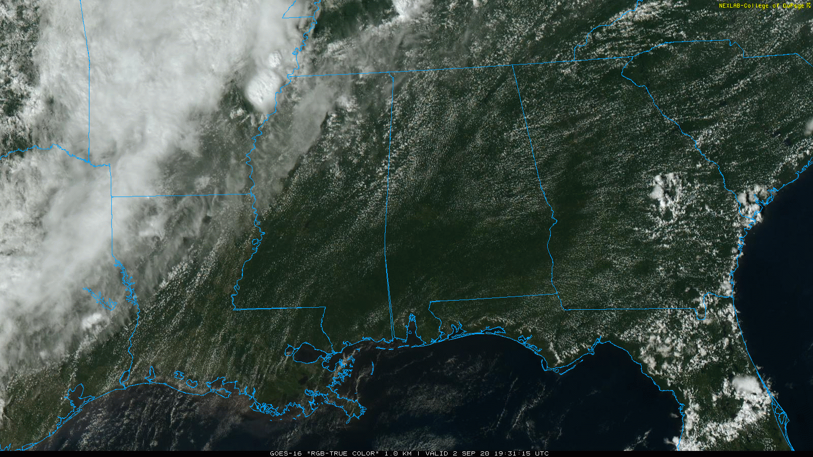
RADAR CHECK: As expected, there is nothing on radar across Alabama as of mid-afternoon. The sky is partly to mostly sunny, and temperatures are mostly in the 87-90 degree range. A rogue shower can’t be totally ruled out over the next few hours, but most places will remain dry.
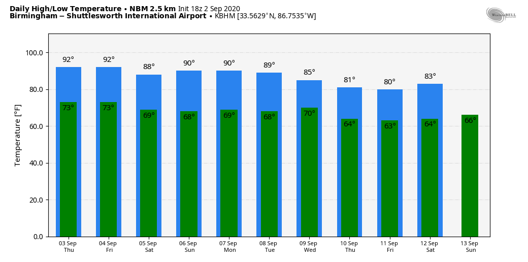
TOMORROW/THURSDAY: Not much change; expect a good supply of sunshine both days with few, if any afternoon showers. The sky will remain partly to mostly sunny, and highs will be in the low 90s, a little above average for early September in Alabama.
LABOR DAY WEEKEND: Heat levels come down a bit; we expect highs in the upper 80s Saturday through Monday. Saturday will remain mostly dry with only a small risk of any one spot seeing an afternoon shower. Then, on Sunday and Monday, we will mention the usual risk of a few random, scattered, mostly afternoon and evening showers or storms. Otherwise, look for partly sunny days and mostly fair nights.
NEXT WEEK: The chance of showers and storms will increase Tuesday and Wednesday ahead of an upper trough and cold front, then a nice surge of cooler and drier air will slip into the state Thursday and Friday. We project highs in the low 80s both days, with potential for lows in the 50s across a decent part of North Alabama.
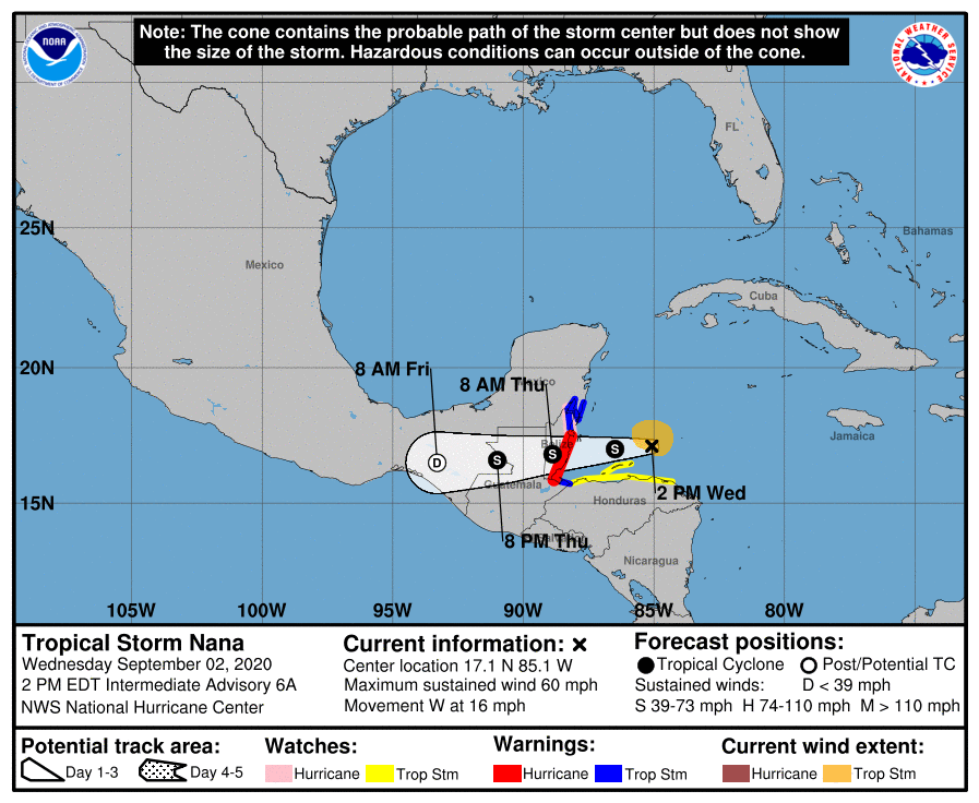
TROPICS: Tropical Storm Nana is still packing sustained winds of 60 mph, and is now expected to remain below hurricane strength with it moves into the coast of Belize tonight. The system will dissipate by Friday inland over Central America… it is no threat to the Gulf of Mexico.
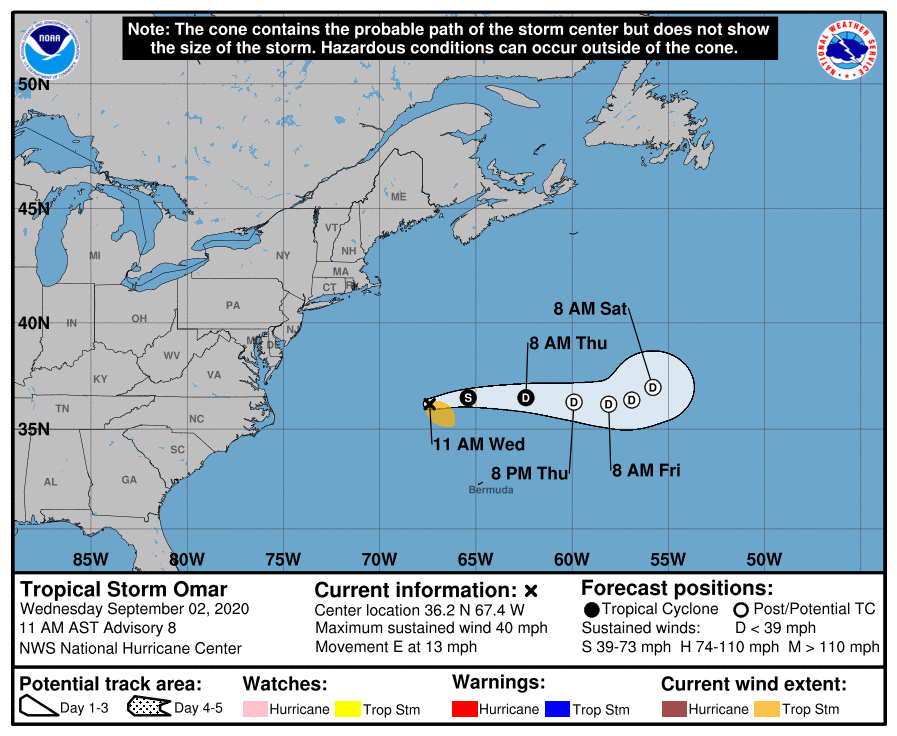
And, in the Atlantic well east of the U.S., Tropical Storm Omar is barely a tropical storm, and will dissipate over the next few days far from land.
Elsewhere, an area of low pressure located about midway between the Windward Islands and west Africa is producing a small area of showers and thunderstorms. Some development of this system is possible this week as it drifts generally westward over the eastern and central tropical Atlantic Ocean. This system will remain over the open Atlantic for the foreseeable future.
And, a tropical wave, located just off the coast of west Africa, is producing limited shower activity. The wave is expected to merge with a disturbance centered a couple of hundred miles southeast of the Cabo Verde Islands toward the end of the week. Gradual development of this system is then possible, and a tropical depression could form over the weekend while it moves westward over the eastern and central tropical Atlantic Ocean. Way too early to know if this will reach the Caribbean, or impact any land area.
The Gulf of Mexico remains quiet, and we expect routine weather on the Central Gulf Coast (Gulf Shores to Panama City Beach) over the Labor Day weekend with the usual mix of sun and scattered storms.
ON THIS DATE IN 1935: The Great Labor Day Hurricane of 1935 (formally known as Hurricane Three) struck the Florida Keys. It was the most intense Atlantic hurricane to make landfall on record in terms of pressure, and tied with Hurricane Dorian in 2019 for the strongest landfalling Atlantic hurricane by maximum sustained winds, with winds of 185 mph. It was also the most intense Atlantic hurricane on record until Hurricane Gilbert in 1988. The town of Islamorada was obliterated.
It was late summer, in the depths of the Great Depression. In the once-prosperous city of Key West, residents were trying to survive on an average monthly income of $7—about $125 in 2017 dollars. The city had declared bankruptcy. At least 408 were killed in the storm—almost half the people living between Key West and Miami. Included in the death toll were 250 veterans in a World War I veterans in a rehabilitation camp.
BEACH FORECAST: Click here to see the AlabamaWx Beach Forecast Center page.
WEATHER BRAINS: Don’t forget you can listen to our weekly 90 minute show anytime on your favorite podcast app. This is the show all about weather featuring many familiar voices, including our meteorologists here at ABC 33/40.
CONNECT: You can find me on all of the major social networks…
Facebook
Twitter
Instagram
Pinterest
Snapchat: spannwx
Look for the next Weather Xtreme video here by 7:00 a.m. tomorrow….
Category: Alabama's Weather, ALL POSTS, Weather Xtreme Videos
About the Author (Author Profile)
James Spann is one of the most recognized and trusted television meteorologists in the industry. He holds the AMS CCM designation and television seals from the AMS and NWA. He is a past winner of the Broadcast Meteorologist of the Year from both professional organizations.Subscribe
If you enjoyed this article, subscribe to receive more just like it.


