

Nana is Rapidly Weakening Over Northern Guatemala & Southeastern Mexico
SUMMARY OF 1000 AM CDT…1500 UTC…INFORMATION
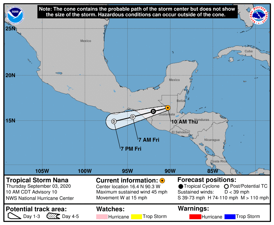
LOCATION…16.4N 90.3W
ABOUT 125 MI…200 KM N OF GUATEMALA CITY GUATEMALA
MAXIMUM SUSTAINED WINDS…45 MPH…75 KM/H
PRESENT MOVEMENT…W OR 260 DEGREES AT 15 MPH…24 KM/H
MINIMUM CENTRAL PRESSURE…1004 MB…29.65 INCHES
WATCHES AND WARNINGS
There are no coastal watches or warnings in effect.
DISCUSSION AND OUTLOOK
At 1000 AM CDT (1500 UTC), the center of Tropical Storm Nana was located near latitude 16.4 North, longitude 90.3 West. Nana is moving toward the west near 15 mph (24 km/h), and a westward to west-southwestward motion is expected through Friday night. On the forecast track, the center of Nana will move over northern Guatemala and southeastern Mexico today and tonight, then move over the Gulf of Tehuantepec on Friday.
Maximum sustained winds are near 45 mph (75 km/h) with higher gusts. Continued rapid weakening is forecast, and Nana will likely become a remnant low on Friday.
Tropical-storm-force winds extend outward up to 45 miles (75 km) from the center.
The estimated minimum central pressure is 1004 MB (29.65 inches).
HAZARDS AFFECTING LAND
WIND: Tropical storm conditions will continue near the center of Nana for a few more hours.
STORM SURGE: Water levels along the Belize coast will gradually subside today.
RAINFALL: Nana is expected to produce the following rainfall accumulations through Friday:
Central to western Guatemala and the Mexican state of Chiapas: 3 to 6 inches, isolated totals of 8 inches.
These rainfall amounts may produce life-threatening flash floods and mudslides.
SURF: Swells generated by Nana affecting portions of the coasts of the northwestern Caribbean Sea should subside today.
Category: ALL POSTS, Severe Weather, Tropical
About the Author (Author Profile)
Scott Martin is an operational meteorologist, professional graphic artist, musician, husband, and father. Not only is Scott a member of the National Weather Association, but he is also the Central Alabama Chapter of the NWA president. Scott is also the co-founder of Racecast Weather, which provides forecasts for many racing series across the USA. He also supplies forecasts for the BassMaster Elite Series events including the BassMaster Classic.Subscribe
If you enjoyed this article, subscribe to receive more just like it.


