

Moisture Levels Slowly Rise In Coming Days
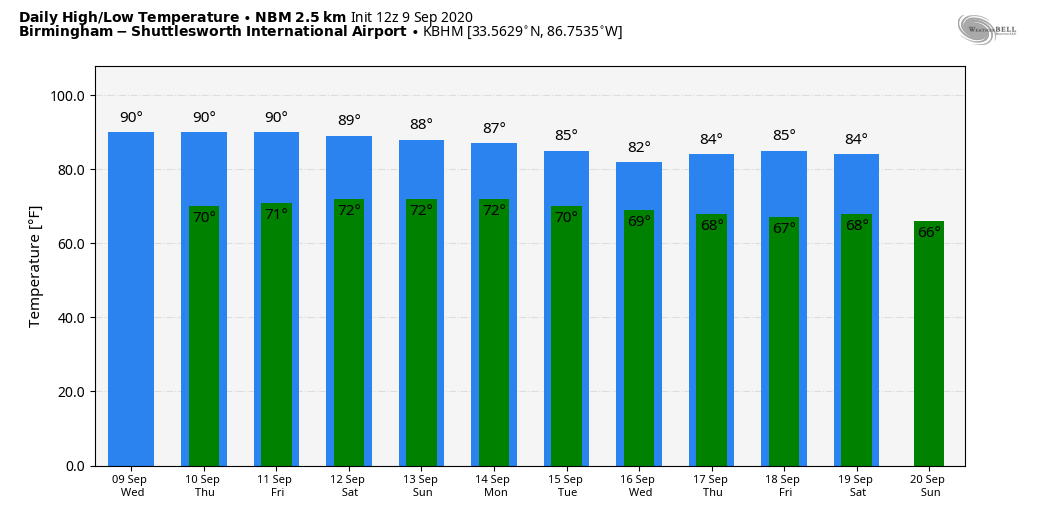
WARM, DRY AFTERNOON: Another quiet day in the weather office. The sky is mostly sunny across Alabama with temperatures generally in the upper 80s, right at seasonal averages. Tonight will be mostly fair with a low between 69 and 73 degrees.

TOMORROW THROUGH THE WEEKEND: We will mention just a few isolated showers tomorrow afternoon; most of the state will stay dry, however with a partly sunny sky along with a high in the upper 80s. Then, look for an increase in the number of showers and thunderstorms Friday and over the weekend as moisture levels rise. Understand the weekend won’t be a “wash-out”, but there will be a number of showers and storms around both days, especially from noon to midnight. Each day we will have a mixture of clouds and sun, and highs will be mostly in the mid 80s.
NEXT WEEK: A fairly moist airmass will remain parked across the state through the week, so each day will feature a partly sunny sky along with the chance of “scattered, mostly afternoon and evening showers and thunderstorms”. Highs will remain in the 80s, very close to seasonal averages for mid-September in Alabama. See the Weather Xtreme video for maps, graphics, and more details.
TROPICS: We are watching two tropical waves, and two tropical storms in the Atlantic basin today. Invest 94L is a small area of low pressure located about 300 miles southeast of Wilmington, North Carolina, and continues to produce disorganized showers and thunderstorms near its center of circulation. It is moving toward the coast of the Carolinas, and NHC gives it only a low chance (30 percent) of becoming a depression before reaching land. It will mainly be a rain producer for the middle Atlantic coast region.
A tropical wave is forecast to emerge off the west coast of Africa on Thursday. Gradual development is expected once the system moves over water, and a tropical depression is likely to form late this week or over the weekend while the system moves generally westward across the eastern tropical Atlantic. NHC gives it an 80 percent chance of becoming a depression or storm over the next five days; way too early to know if it will impact the U.S. or any land mass. Just something to watch for now.
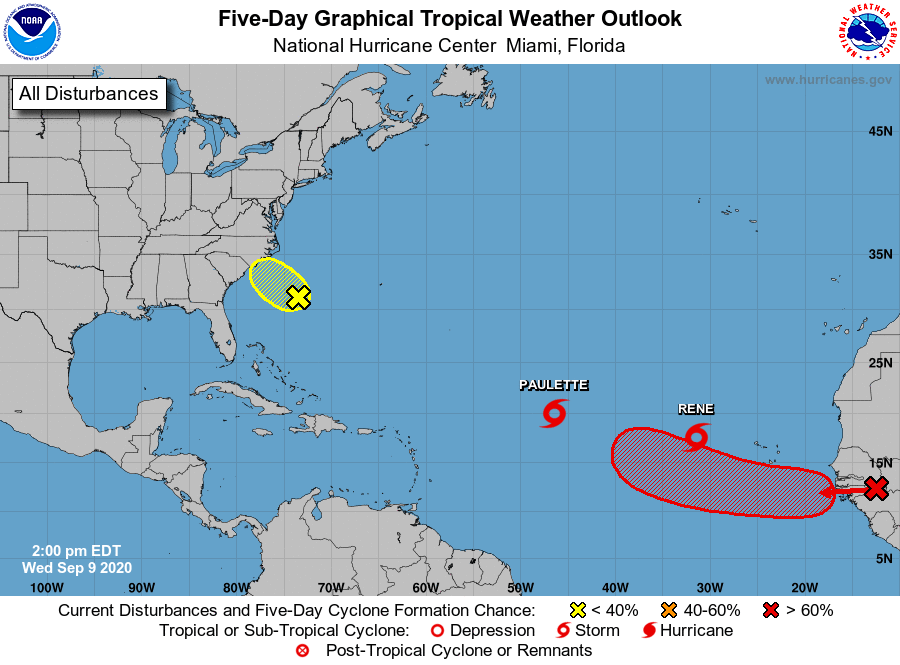
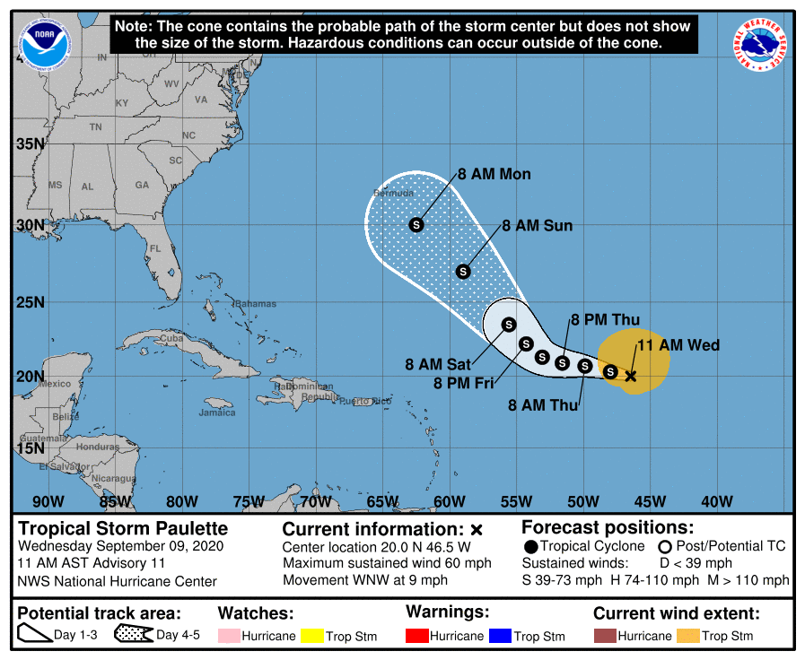
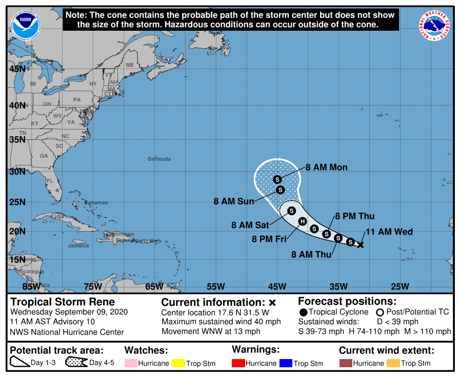
PAULETTE/RENE: Tropical storms Paulette and Rene in the Atlantic will gain latitude by the weekend, and both systems most likely won’t impact the U.S as they remain far to the east, far from land. There is some chance Paulette could be close to Bermuda over the weekend; it is not expected to reach hurricane strength.
The Gulf of Mexico will remain quiet for the next five to seven days.
ON THIE DATE IN 1965: Hurricane Betsy slammed into New Orleans; 110 mph winds and power failures were reported in New Orleans. The eye of the storm passed to the southwest of New Orleans on a northwesterly track. The northern and western eyewalls covered Southeast Louisiana and the New Orleans area from about 8 PM until 4 AM the next morning. In Thibodaux, winds of 130 mph to 140 mph were reported. Hurricane Betsy was the first hurricane to accrue damages over $1 billion, and was thus nicknamed “Billion Dollar Betsy.” Due to the tremendous amount of damage caused, “Betsy” was retired from the hurricane list and replaced with the name “Blanche”.
ON THIS DATE IN 2017: Hurricane Irma was weakening a bit over Cuba after making landfall the night before at category five strength. This made Irma only the second Category 5 hurricane to strike Cuba in recorded history, after the 1924 Cuba hurricane. It was also the third strongest Atlantic hurricane at landfall ever recorded, just behind the 1935 Labor Day Hurricane and Hurricane Dorian. The hurricane strengthened back into a Category 4 prior to hitting the Keys. The Florida Keys suffered the worst of the damage in the United States.
BEACH FORECAST: Click here to see the AlabamaWx Beach Forecast Center page.
WEATHER BRAINS: Don’t forget you can listen to our weekly 90 minute show anytime on your favorite podcast app. This is the show all about weather featuring many familiar voices, including our meteorologists here at ABC 33/40.
CONNECT: You can find me on all of the major social networks…
Facebook
Twitter
Instagram
Pinterest
Snapchat: spannwx
Look for the next Weather Xtreme video here by 7:00 a.m. tomorrow…
Category: Alabama's Weather, ALL POSTS, Weather Xtreme Videos
About the Author (Author Profile)
James Spann is one of the most recognized and trusted television meteorologists in the industry. He holds the AMS CCM designation and television seals from the AMS and NWA. He is a past winner of the Broadcast Meteorologist of the Year from both professional organizations.Subscribe
If you enjoyed this article, subscribe to receive more just like it.


