

A Few Scattered Showers Possible Later Today; Eyes On The Tropics
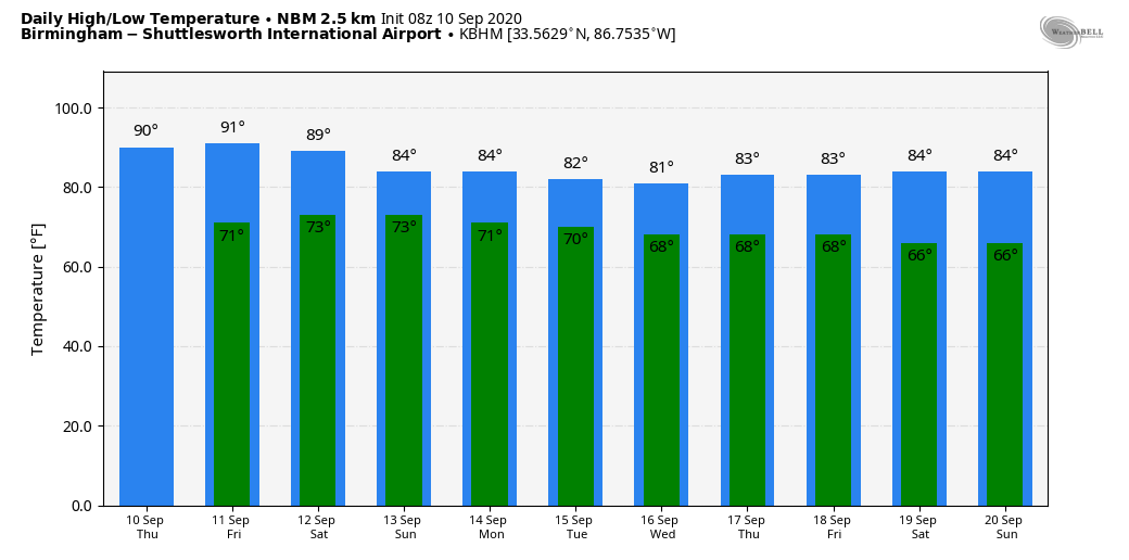
MOISTURE LEVELS RISING: We will bring in the chance of a few scattered showers this afternoon across Alabama; odds of any one spot getting wet will be around one in four. Otherwise, today will be partly sunny and a little more humid with a high in the upper 80s. The average high for September 10 at Birmingham is 87.
TOMORROW THROUGH THE WEEKEND: We are expecting an increase in the number of showers and storms across the Deep South as a tropical wave moves into the Gulf of Mexico. Chance of one community seeing rain tomorrow is around 30 percent, and then 60-80 percent over the weekend. Still, the weekend won’t be a “wash-out”, but understand a few periods of rain are likely along with potential for some thunder. Most, but not necessarily all of the rain will come in the window from noon to midnight. Sunshine will be limited Saturday and Sunday, and highs will be in the low to mid 80s.
NEXT WEEK: A moist airmass will hang over Alabama through the week, so each day look for a mix of sun and clouds with scattered, mostly afternoon and evening showers and thunderstorms. Highs will remain in the 80s… See the Weather Xtreme video for maps, graphics, and more details.
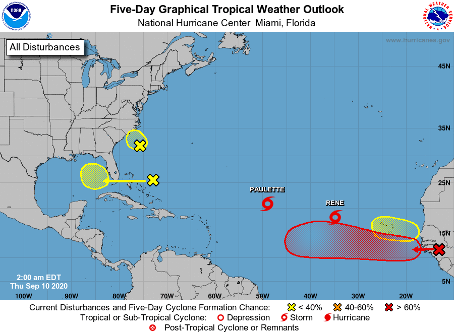
TROPICS: We are at the climatological peak of the Atlantic basin hurricane season, and as expected there is a good bit of activity to discuss this morning with three tropical waves and two tropical storms on the board.
One tropical wave will move into the North Carolina coast within the next 36 hours; NHC gives it only a 10 percent chance of development. It will be mainly a rain maker for the mid-Atlantic coast region.
Another tropical wave will move westward through the Bahamas today; it will wind up in the eastern Gulf of Mexico over the weekend. For now NHC gives it a 20 percent chance of development through early next week. This feature will help to bring enhanced moisture levels to parts of the Gulf Coast and Deep South region in coming days with higher rain chances.
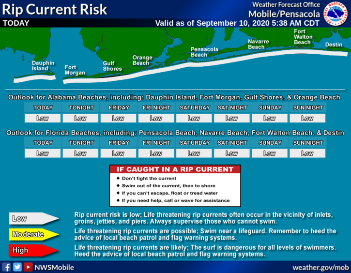
If you are headed to the Central Gulf Coast (Gulf Shores to Panama City Beach); the wave will likely bring a few periods of rain over the weekend and early next week, but not a total “wash-out” Saturday and Sunday. You will see some sun. And, for now the rip current danger is low along the coast through the weekend.
And, a third well organized tropical wave will move off the coast of Africa today. NHC gives it a 90 percent chance of developing over the next five days; the name will be “Sally” when it reaches tropical storm strength. No way of knowing now if it will impact the U.S. or any land mass.
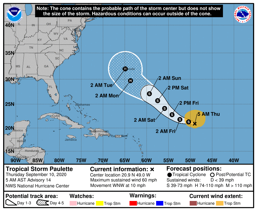
TROPICAL STORM PAULETTE: Paulette has 60 mph winds this morning, and is centered about 930 miles east/northeast of the northern Leeward Islands. The latest NHC forecast track now shows the system reaching hurricane strength late this weekend, and it is forecast to be very close to Bermuda Monday or Monday night. From there, the system should recurve sharply into the open Atlantic and is no threat to the U.S.
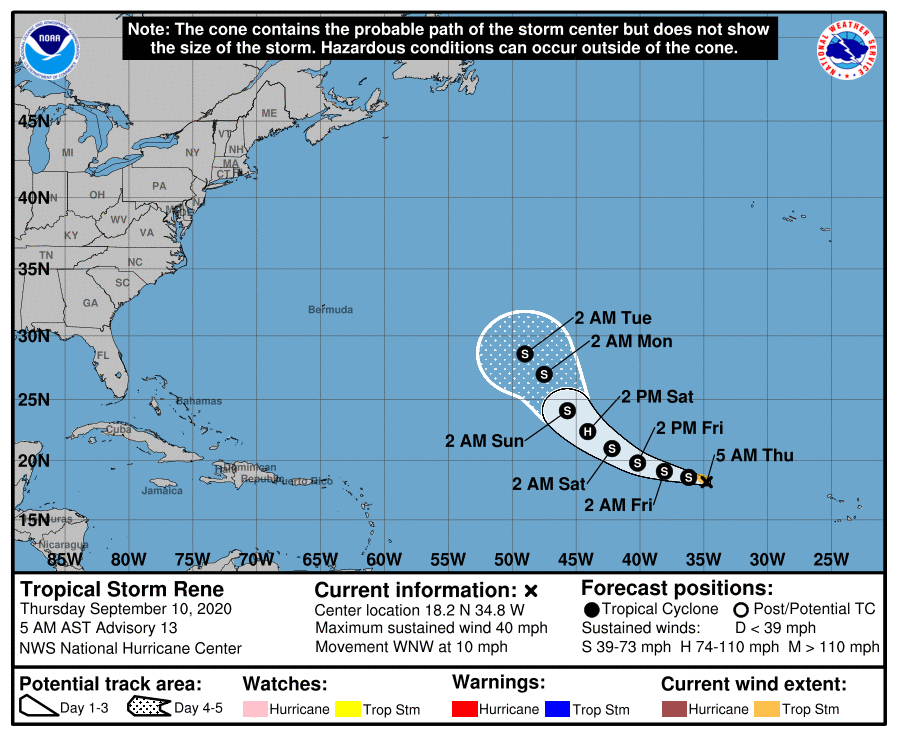
TROPICAL STORM RENE: Rene is a weak system in the eastern Atlantic with winds of 40 mph. It is forecast to briefly become a hurricane Saturday before weakening again; this one will gain latitude and will likely remain far from land.
ON THIS DATE IN 1960: The center of Hurricane Donna passed over the middle of the Florida Keys between 2, and 3 am on this day. Donna was a Category 5 hurricane over the Atlantic and a Category 4 at landfall. This storm caused the deaths of over 100 in Puerto Rico, 50 in the United States.
BEACH FORECAST: Click here to see the AlabamaWx Beach Forecast Center page.
WEATHER BRAINS: Don’t forget you can listen to our weekly 90 minute show anytime on your favorite podcast app. This is the show all about weather featuring many familiar voices, including our meteorologists here at ABC 33/40.
CONNECT: You can find me on all of the major social networks…
Facebook
Twitter
Instagram
Pinterest
Snapchat: spannwx
Look for the next Weather Xtreme video here by 4:00 this afternoon… enjoy the day!
Category: Alabama's Weather, ALL POSTS, Weather Xtreme Videos
About the Author (Author Profile)
James Spann is one of the most recognized and trusted television meteorologists in the industry. He holds the AMS CCM designation and television seals from the AMS and NWA. He is a past winner of the Broadcast Meteorologist of the Year from both professional organizations.Subscribe
If you enjoyed this article, subscribe to receive more just like it.


