

TD-19 Nearing South Florida; Tropical Storm Watch Issued for a Portion of the Florida Panhandle
SUMMARY OF 1100 PM EDT…0300 UTC…INFORMATION
———————————————–
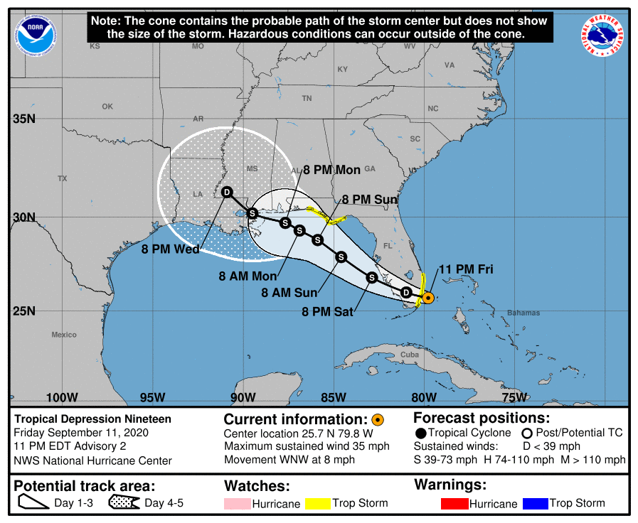
LOCATION…25.7N 79.8W
ABOUT 25 MI…40 KM ESE OF MIAMI FLORIDA
MAXIMUM SUSTAINED WINDS…35 MPH…55 KM/H
PRESENT MOVEMENT…WNW OR 295 DEGREES AT 8 MPH…13 KM/H
MINIMUM CENTRAL PRESSURE…1007 MB…29.74 INCHES
WATCHES AND WARNINGS
——————–
A Tropical Storm Watch is in effect for…
* South of Jupiter Inlet to the north of Ocean Reef
* Ochlockonee River to Okaloosa/Walton County Line
DISCUSSION AND OUTLOOK
———————-
Doppler radar data from Miami and satellite images indicate that the depression is gradually becoming better organized. The low-level center is estimated to be near the northwestern edge of the main area of deep convection due to some northerly wind shear. Surface observations and satellite classifications support holding the initial intensity at 30 kt. The minimum pressure appears to be a little lower than before, now 1007 MB.
The tropical depression is moving west-northwestward at about 7 kt. A subtropical ridge extending from the southeast U.S. to the western Atlantic should steer the depression west-northwestward across south Florida tonight and Saturday morning and then over the eastern Gulf of Mexico late Saturday and Sunday. After that time, the ridge is forecast to weaken due to an approaching trough, but the trough is not expected to be strong enough to cause the cyclone to turn northward. Instead, the models suggest that a slow west-northwestward motion very near the northern Gulf coast is likely during the early and middle portions of next week. Although the models all show a relatively similar scenario, there is a fair amount of spread by the time the system nears the northern Gulf coast. The NHC track forecast lies roughly near the middle of the guidance envelope close to the consensus aids. Several of the local National Weather Service forecast offices across the southeast U.S. will be launching weather balloons four times per day, which should provide the models with excellent data in hopes to provide better track guidance during the next couple of days.
Since the depression is expected to move over very warm SSTs, once it reaches the eastern Gulf of Mexico tomorrow, and remain in an environment of low wind shear and high moisture, gradual strengthening seems likely. The models suggest that there could be an increase in westerly shear around the time the cyclone is forecast to move inland along the northern Gulf coast in about 4 days. Based on these expected environmental conditions, strengthening is forecast during the next few days, and the NHC intensity forecast follows the trend of the IVCN and HCCA models. The depression will likely be at or near hurricane strength when it reaches the northern Gulf Coast.
Users are reminded not to focus on the exact details of the track or intensity forecast as the average NHC track error at 96 h is around 150 miles and the average intensity error is around 15 mph. In addition, winds, storm surge, and rainfall hazards will extend far from the center.
KEY MESSAGES
———————-
1. Heavy rainfall is expected to produce isolated flash flooding over portions of central and southern Florida and prolong existing minor river flooding across central Florida.
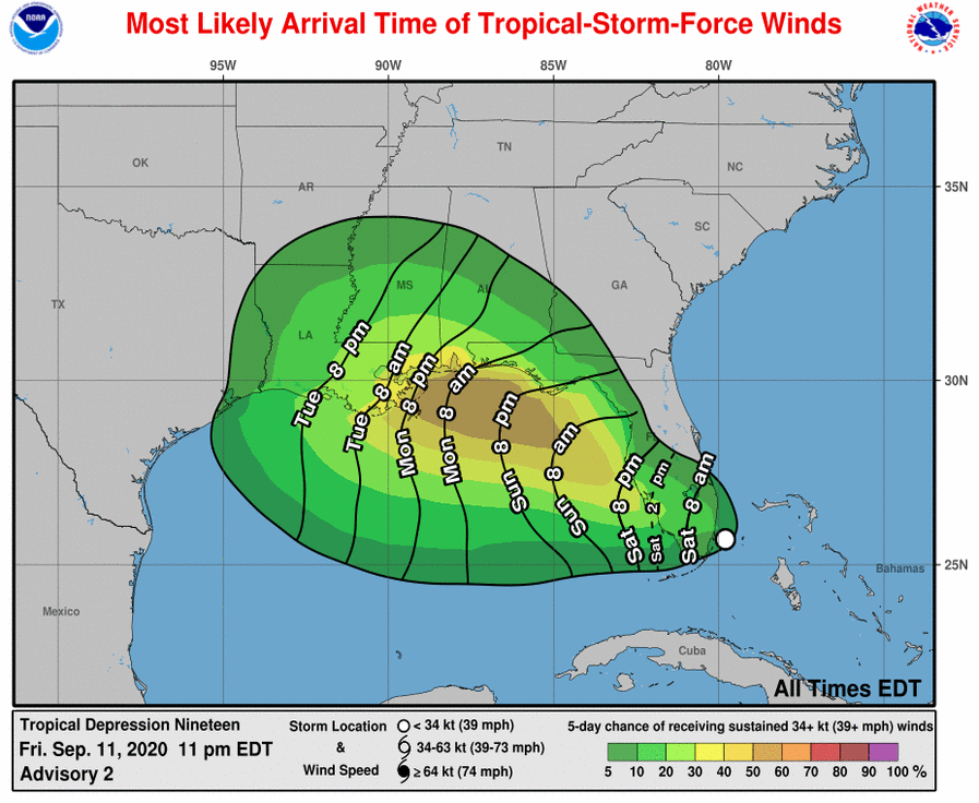
2. Tropical storm conditions are possible overnight and early Saturday along the southeast Florida coast where a Tropical Storm Watch is in effect. Tropical storm conditions are possible by Sunday night in portions of the Florida Panhandle, where a Tropical Storm Watch has been issued.
3. The system is forecast to strengthen to near hurricane intensity by early next week as it moves across the northeastern Gulf of Mexico. Dangerous impacts from storm surge, wind, and heavy rainfall will be possible along the Gulf Coast from the Florida Panhandle to southeastern Louisiana late this weekend and early next week. Residents in these areas should monitor the progress of this system and updates to the forecast, as Storm Surge, Tropical Storm or Hurricane watches could be issued on Saturday.
Category: Alabama's Weather, ALL POSTS, Severe Weather, Tropical
About the Author (Author Profile)
Scott Martin is an operational meteorologist, professional graphic artist, musician, husband, and father. Not only is Scott a member of the National Weather Association, but he is also the Central Alabama Chapter of the NWA president. Scott is also the co-founder of Racecast Weather, which provides forecasts for many racing series across the USA. He also supplies forecasts for the BassMaster Elite Series events including the BassMaster Classic.Subscribe
If you enjoyed this article, subscribe to receive more just like it.


