

Sunday Weather Xtreme Video: Sally to Bring Life Threatening Surge, Wind, Flooding to the Gulf Coast
All eyes are on the Gulf of Mexico as we monitor Tropical Storm Sally over the southeastern Gulf of Mexico. It will impact the northern Gulf Coast as a hurricane late Monday into Wednesday and will be a factor in Central Alabama’s weather in the midweek time frame with heavy rain, wind, and the possibility of tornadoes. Let’s get the particulars.
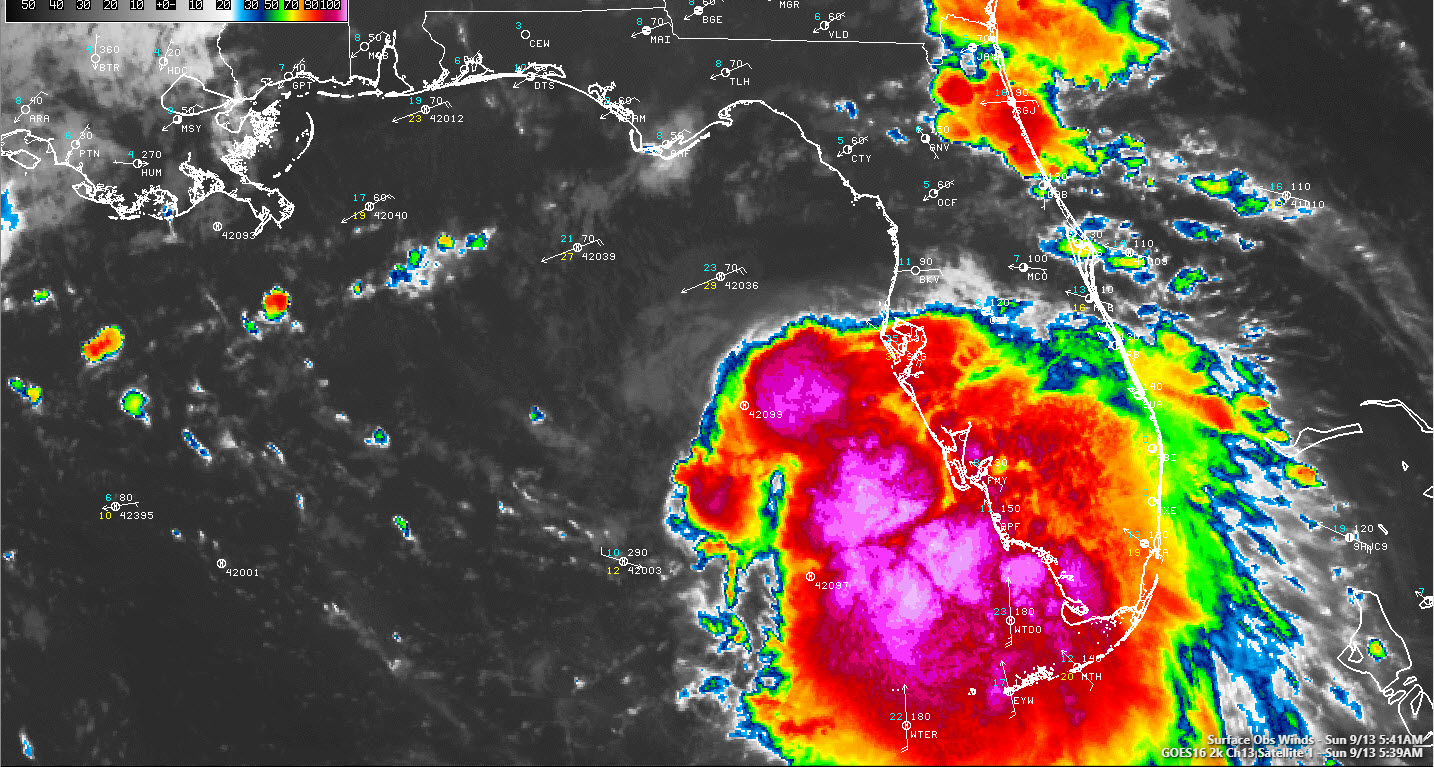
4 AM LOOK AT SALLY: The center of Tropical Storm Sally is 344 miles southeast of Mobile this morning. Top winds are 50 mph, with most of the strong winds to the east of the center. The system should become better organized today, which will allow it to take advantage of warm ocean temperatures and lower shear to steadily intensify until it nears the coast. It could rapidly intensify on Monday, which is a concern. The current forecast is for maximum winds to be at 100 mph before landfall. It could conceivably be a little stronger.
LANDFALLS: The official track says initial landfall should occur near the Mouth of the Mississippi River around 9 p.m. Monday evening, with the center passing directly over New Orleans during the late morning and noon hours, passing over the Northshore a short time later. we are warned though that the errors this far our mean it could be as far west as Atchafalaya Bay and as far east as Mobile Bay. Very different impacts for each location along the coast based on those scenarios or anything in between.
WATCHES/WARNINGS: Hurricane Warnings are now in effect for southeastern Louisiana including the New Orleans area and Hancock and Harrison Counties on the Mississippi Coast. A Hurricane Watch is in effect for Assumption, Terrebonne, and Lafourche Parishes in Lousiana, and for the rest of the Mississippi and Alabama coasts. Tropical Storm Warnings are in effect from Ocean Springs MS to Indian Pass, Florida, or course including all of the Alabama coast and the Northwest Florida coast.
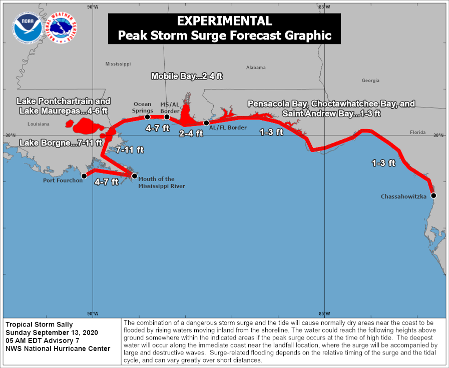
A Storm Surge Warning is in effect from Port Fourchon Louisiana to the Mississippi/Alabama Border including Lake Pontchartrain, Lake Maurepas, and Lake Borgne. A Storm Surge Watch is in effect from the Mississippi/Alabama Border to the Alabama/Florida Border.
CENTRAL ALABAMA IMPACTS: The center will turn north and northeast, passing through southern Mississippi Tuesday night and Wednesday morning and weakening as it goes. It will move into west Central Alabama late Wednesday night and early Thursday morning. It will have weakened to a tropical depression by that time but will still be accompanied by winds of 30-35 mph. Rain will increase in coastal Alabama and Northwest Florida on Monday and spread into South Alabama on Tuesday.
The heaviest rain will spread into Southwest Alabama Wednesday afternoon and spread north and northeast Wednesday night and Thursday into Central Alabama. Periods of heavy rain will be a threat through Thursday. Rainfall amounts will reach 3-4 inches north of I-20, and 3-5 inches south of I-20, with amounts approaching 4-6 inches over areas south and west of Tuscaloosa. Flooding may become a threat.
Winds will become breezy on Tuesday across Central Alabama, gusting to 20 mph at times, and 30 mph during the nighttime hours as Sally turns north and northeast. Winds will gust to over 35 mph on Wednesday and wind advisories may be necessary. Winds will average 30 mph with higher gusts on Thursday as the center of the depression passes through.
Tornadoes will be a threat, most likely Wednesday afternoon over Southwest Alabama, pushing into West Central Alabama Wednesday night and early Thursday, continuing during the day Thursday across Central Alabama.
WHILE WE’RE WAITING: Today will start off with some low clouds that will break up during the morning hours, leading to partly cloudy skies during the day as some subsidence from the tropical storm begins to impact the area. It will be hot, with highs near 90f in the I-20 Corridor, upper 80s North, and mid 80s Northwest, where scattered showers and storms will be traversing the area ahead of the trough to the northwest. Winds will become gusty at times, out of the east, mainly east of I-65. Winds could gust to over 20 mph over southeastern sections. Skies will be partly cloudy overnight, with lows in the lower 70s. Monday will feature increasing clouds with highs in the upper 80s. Rain and storms will be moving into South Alabama with scattered showers and storms over Central Alabama. Tuesday will see that rain shield moving northward slowly with mostly cloudy skies. Highs will be in the lower 80s, with some upper 70s over southern sections. Winds will run 15-25 with higher gusts. Wednesday will see highs in the upper 70s, with readings near 80F North. Gusty winds will be picking up and increasing rain chances.
AFTER THE STORM: Rain chances will be slowly going down Thursday and nicer conditions will prevail into the weekend as the departing storm pulls some drier, cooler conditions down into Alabama. Highs into the weekend will be in the lower 80s, with lows in the lower 60s. Skies will be partly cloudy with just a few scattered showers Saturday and dry conditions Sunday through Wednesday before a cold front brings showers back late in the week.
VOODOOLAND: End of the period, Sunday, September 27th, looks like a return to humid and warm conditions with scattered showers and storms. Nothing look threatening in the tropics which is good news.
BUT FOR NOW: Hurricane Paulette will make a direct hit on Bermuda Monday morning. Conditions will be deteriorating on that beautiful island nation later today. Winds should be right around 90-95 mph, which would put the hurricane in the top 7 or 8 in terms of intensity for Bermuda. Of course, storm surge, high surf, heavy rain, and wind damage will be likely. Rene will become a remnant low over the Central Atlantic by Monday. And tropical depression 20 will become Tropical Storm Teddy later today. It is no threat to land though and will follow Paulette out to sea. It could become a major hurricane before it does though. There are two disturbances behind #20/Teddy One will likely become a tropical depression/tropical storm this week, and it may take a more westward track.
BEACHCAST:
PANAMA CITY/ST. JOE
TROPICAL STORM WATCH IN EFFECT
Partly sunny today. Mostly cloudy Monday and Tuesday. A slight chance of showers and storm through the period. Seas running 1-2 feet, but rip current risk becoming high later today and especially tonight and Monday through Tuesday. Highs will be in the middle and upper 80s. Winds today will be out of the east at 20 mph, and southeast at 15-20 mph on Monday. Tuesday, winds will be southeast around 15 mph. Tides will run 1-2 feet above normal Monday and lasting into Tuesday. Moderate rip current risk today, becoming high tonight and staying high through Tuesday. Flash flood watches are in effect from Sunday morning through Tuesday evening.
SANDESTIN/BEACHES OF 30A
TROPICAL STORM WATCH IN EFFECT
Mostly sunny today, becoming mostly cloudy tonight and Monday. Mostly cloudy through Wednesday. Slight chance of showers and storms through Wednesday. Surf running 1-2 feet today, increasing to 2-3 feet Monday and 3-5 feet Tuesday. East and southeast winds 15-20 mph. Highs in the upper 80s today, and lower 80s Monday and Tuesday. Tides will run 2-3 feet above normal Monday and Tuesday. Moderate rip current risk today, becoming high tonight and staying high through Tuesday. Flash flood watches are in effect from Sunday morning through Tuesday evening.
PENSACOLA BEACH/NAVARRE/FORT WALTON
TROPICAL STORM WATCH IN EFFECT
Mostly sunny today, becoming mostly cloudy tonight and Monday. Mostly cloudy through Wednesday. Slight chance of showers and storms through Monday night. Showers and storms like Tuesday through Wednesday. Surf running 1-2 feet today, increasing to 2-3 feet Monday and 3-5 feet Tuesday. East and southeast winds 15-20 mph. Highs in the upper 80s today, mid-80s Monday, and lower 80s Tuesday. Tides will run 2-3 feet above normal Monday and Tuesday. Moderate rip current risk today, becoming high tonight and staying high through Tuesday. Flash flood watches are in effect from Monday morning through Thursday morning.
ALABAMA COAST
HURRICANE WATCH/TROPICAL STORM WARNING IN EFFECT
Mostly sunny today, becoming mostly cloudy tonight and Monday with a chance of showers and storms. Showers and storms Tuesday and Wednesday. Surf running 3-4 feet today, increasing to 10-11 feet Monday and Monday night, dropping to around 7 feet Tuesday. East 10-15 mph today mph, shifting to northeast and increasing to 25 mph on Monday. Winds will increase to around 40 mph Monday night and stay breezy through Tuesday night, averaging 25 mph. Highs in the upper 80s today, mid-80s Monday, and lower 80s Tuesday. Tides will run 2-4 feet above normal Monday and Tuesday. Moderate rip current risk today, becoming high tonight and staying high through Tuesday. Flash flood watches are in effect from Monday morning through Thursday morning.
Click here to see the Beach Forecast Center page.
DANCING WITH THE STATS: According to Phil Klotzbach, as of yesterday, we were on our 51st day in 2020 with a named storm in the Atlantic. Only five years in the satellite era had more by September 12th: 1995, 2005, 2008, 2011, and 2012.
ADVERTISE WITH US: Deliver your message to a highly engaged audience by advertising on the AlabamaWX.com website. The site enjoyed 17.2 MILLION pageviews in the past 12 months. Don’t miss out! We can customize a creative, flexible and affordable package that will suit your organization’s needs. Contact me, Bill Murray, at (205) 687-0782 and let’s talk.
WEATHERBRAINS: This week, the panel will entertain our own Taylor Sarallo and Matt Havin from Baron, as well as Donald Jose from the NWS in Lake Charles. I am sure lots of time will be spent on Sally as well. And we will have a special guest appearance Check out the show at www.WeatherBrains.com. You can also subscribe on iTunes. You can watch the show live at live.bigbrainsmedia.com or on James’ YouTube Channel You will be able to see the show on the James Spann 24×7 weather channel on cable or directly over the air on the dot 2 feed.
ON THIS DATE IN 2008: Many people living on the Bolivar Peninsula east of Galveston TX didn’t evacuate in advance of Hurricane Ike and had to be rescued from the 12-foot storm surge which destroyed the majority of the homes in the area. Over one hundred people died from Ike and damage exceeded $37 billion. Follow my weather history tweets on Twitter. I am @wxhistorian at Twitter.com.
Category: Alabama's Weather, ALL POSTS, Tropical
About the Author (Author Profile)
Bill Murray is the President of The Weather Factory. He is the site's official weather historian and a weekend forecaster. He also anchors the site's severe weather coverage. Bill Murray is the proud holder of National Weather Association Digital Seal #0001 @wxhistorianSubscribe
If you enjoyed this article, subscribe to receive more just like it.


