

Sally Expected to Strengthen Tonight and Monday
Tropical Storm Sally is getting better organized this morning, with thunderstorm firing near the center, which is now about 310 mile southeast of Mobile.
Top winds are now 60 mph.
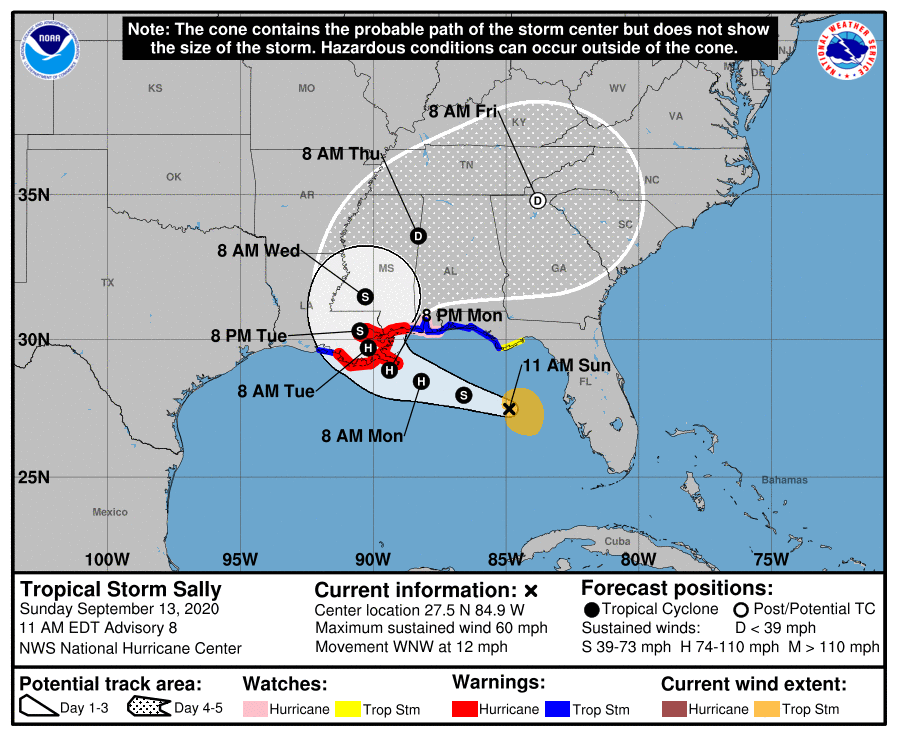
The new 10 a.m. official track is a little faster and shifted a little west with landfall near Grand Isle as a 90 mph category 1 hurricane. It could be stronger cautions the NHC.
It still curves it north over southern Mississippi and into Central Alabama as a depression early Thursday morning.
Here is the official 10 a.m. advisory:
BULLETIN
Tropical Storm Sally Advisory Number 8
NWS National Hurricane Center Miami FL AL192020
1100 AM EDT Sun Sep 13 2020
…SALLY EXPECTED TO STRENGTHEN TONIGHT AND MONDAY…
…LIFE-THREATENING STORM SURGE, HURRICANE-FORCE WINDS AND HEAVY
RAINFALL EXPECTED ALONG PORTIONS OF THE NORTHERN GULF COAST
STARTING ON MONDAY…
SUMMARY OF 1100 AM EDT…1500 UTC…INFORMATION
———————————————–
LOCATION…27.5N 84.9W
ABOUT 135 MI…220 KM W OF ST. PETERSBURG FLORIDA
ABOUT 280 MI…450 KM ESE OF THE MOUTH OF THE MISSISSIPPI RIVER
MAXIMUM SUSTAINED WINDS…60 MPH…95 KM/H
PRESENT MOVEMENT…WNW OR 295 DEGREES AT 12 MPH…19 KM/H
MINIMUM CENTRAL PRESSURE…998 MB…29.48 INCHES
WATCHES AND WARNINGS
——————–
CHANGES WITH THIS ADVISORY:
The Hurricane Warning along the coast of Louisiana has been
extended westward to Morgan City.
A Tropical Storm Warning has been issued for the coast of Louisiana
from west of Morgan City to Intracoastal City.
SUMMARY OF WATCHES AND WARNINGS IN EFFECT:
A Storm Surge Warning is in effect for…
* Port Fourchon Louisiana to the Mississippi/Alabama Border
* Lake Pontchartrain, Lake Maurepas, and Lake Borgne
A Hurricane Warning is in effect for…
* Morgan City Louisiana to Ocean Springs Mississippi
* Lake Pontchartrain and Lake Maurepas including metropolitan New
Orleans
A Storm Surge Watch is in effect for…
* Mississippi/Alabama Border to the Alabama/Florida Border
A Hurricane Watch is in effect for…
* East of Ocean Springs to the Alabama/Florida Border
A Tropical Storm Warning is in effect for…
* East of Ocean Springs to Indian Pass
* Intracoastal City Louisiana to west of Morgan City
A Tropical Storm Watch is in effect for…
* Indian Pass to Ochlockonee River Florida
A Storm Surge Warning means there is a danger of life-threatening
inundation, from rising water moving inland from the coastline,
during the next 36 hours in the indicated locations. For a depiction
of areas at risk, please see the National Weather Service Storm
Surge Watch/Warning Graphic, available at hurricanes.gov. This is a
life-threatening situation. Persons located within these areas
should take all necessary actions to protect life and property from
rising water and the potential for other dangerous conditions.
Promptly follow evacuation and other instructions from local
officials.
A Hurricane Warning means that hurricane conditions are expected
somewhere within the warning area. A warning is typically issued
36 hours before the anticipated first occurrence of
tropical-storm-force winds, conditions that make outside
preparations difficult or dangerous. Preparations to protect life
and property should be rushed to completion.
A Tropical Storm Warning means that tropical storm conditions are
expected somewhere within the warning area within 36 hours.
A Storm Surge Watch means there is a possibility of life-
threatening inundation, from rising water moving inland from the
coastline, in the indicated locations during the next 48 hours.
For a depiction of areas at risk, please see the National Weather
Service Storm Surge Watch/Warning Graphic, available at
hurricanes.gov.
A Hurricane Watch means that hurricane conditions are possible
within the watch area.
A Tropical Storm Watch means that tropical storm conditions are
possible within the watch area, in this case within 12 to 24 hours.
For storm information specific to your area, including possible
inland watches and warnings, please monitor products issued by your
local National Weather Service forecast office.
DISCUSSION AND OUTLOOK
———————-
At 1100 AM EDT (1500 UTC), the center of Tropical Storm Sally was
located near latitude 27.5 North, longitude 84.9 West. Sally is
moving toward the west-northwest near 12 mph (19 km/h), and a
west-northwestward or northwestward motion is expected through
Monday. A decrease in forward speed and a turn toward the north-
northwest is forecast on Monday night, and slow north-northwestward
motion is expected Tuesday. On the forecast track, the center of
Sally will move over the eastern Gulf of Mexico today, move over the
north-central Gulf of Mexico tonight and Monday, and approach the
north-central Gulf Coast within the hurricane warning area late
Monday and Monday night. Sally is expected to move farther inland
over southeastern Louisiana on Tuesday and Tuesday night.
Data from an Air Force Reserve Hurricane Hunter aircraft indicate
that the maximum sustained winds have increased to near 60 mph (95
km/h) with higher gusts. Strengthening is expected over the next
day or so, and Sally is forecast to become a hurricane on Monday,
with some additional strengthening possible before landfall
Monday night.
Tropical-storm-force winds extend outward up to 90 miles (150 km)
primarily to the east of the center.
The latest minimum central pressure estimated from reconnaissance
aircraft data is 998 mb (29.48 inches).
HAZARDS AFFECTING LAND
———————-
Key messages for Sally can be found in the Tropical Cyclone
Discussion under AWIPS header MIATCDAT4 and WMO header WTNT44 KNHC.
STORM SURGE: The combination of a dangerous storm surge and the
tide will cause normally dry areas near the coast to be flooded by
rising waters moving inland from the shoreline. The water could
reach the following heights above ground somewhere in the indicated
areas if the peak surge occurs at the time of high tide…
Mouth of the Mississippi River to Ocean Springs, MS including Lake
Borgne…7-11 ft
Port Fourchon, LA to Mouth of the Mississippi River…4-7 ft
Ocean Springs, MS to MS/AL Border…4-7 ft
Lake Pontchartrain and Lake Maurepas…4-6 ft
MS/AL Border to AL/FL Border including Mobile Bay…2-4 ft
AL/FL Border to Chassahowitzka, FL including Pensacola Bay,
Choctawhatchee Bay, and Saint Andrew Bay…1-3 ft
Burns Point, LA to Port Fourchon, LA…1-3 ft
Overtopping of local levees outside of the Hurricane and Storm
Damage Risk Reduction System is possible where local inundation
values may be higher than those shown above.
The deepest water will occur along the immediate coast near and to
the right of the landfall location, where the surge will be
accompanied by large and damaging waves. Surge-related flooding
depends on the relative timing of the surge and the tidal cycle,
and can vary greatly over short distances. For information
specific to your area, please see products issued by your local
National Weather Service forecast office.
WIND: Hurricane conditions are expected within the warning area
starting late Monday. Tropical storm conditions are possible within
the watch area and expected within the warning area beginning
Monday.
RAINFALL: Sally is expected to produce additional rainfall of 1 to
3 inches across southwestern Florida with isolated amounts of 6
inches along that coast through Monday. This rainfall may produce
flash and urban flooding and prolong high flows and ongoing minor
flooding on rivers across west-central Florida.
Sally is expected to be a slow moving system resulting in
significant flash flooding for the central Gulf Coast through the
middle of the week. Sally is expected to produce rainfall of 6 to 12
inches with isolated amounts of 20 inches over portions of the
central Gulf Coast from the western Florida Panhandle to far
southeast Louisiana from Monday through the middle of the week.
Sally is forecast to turn inland Wednesday and track into the
Southeast with rainfall of 4 to 8 inches possible farther inland
across much of Mississippi and Alabama with further heavy rain
anticipated for portions of Tennessee, northern Georgia and western
North Carolina. Flash and urban flooding is possible, as well as
minor to isolated moderate flooding on rivers for Mississippi and
Alabama. Flash, urban, and minor river flooding is possible for
portions of Tennessee, northern Georgia and western North Carolina.
SURF: Swells will spread northward along the west-central coast of
Florida and reach the Florida Panhandle and the northern Gulf Coast
during the next couple of days. These swells are likely to cause
life-threatening surf and rip current conditions. Please consult
products from your local weather office.
NEXT ADVISORY
————-
Next intermediate advisory at 200 PM EDT.
Next complete advisory at 500 PM EDT.
$$
Forecaster Brown
NNNN
Category: Alabama's Weather, ALL POSTS, Tropical
About the Author (Author Profile)
Bill Murray is the President of The Weather Factory. He is the site's official weather historian and a weekend forecaster. He also anchors the site's severe weather coverage. Bill Murray is the proud holder of National Weather Association Digital Seal #0001 @wxhistorianSubscribe
If you enjoyed this article, subscribe to receive more just like it.


