

Paulette to Pass Near Bermuda Before Dawn with 100 mph Winds
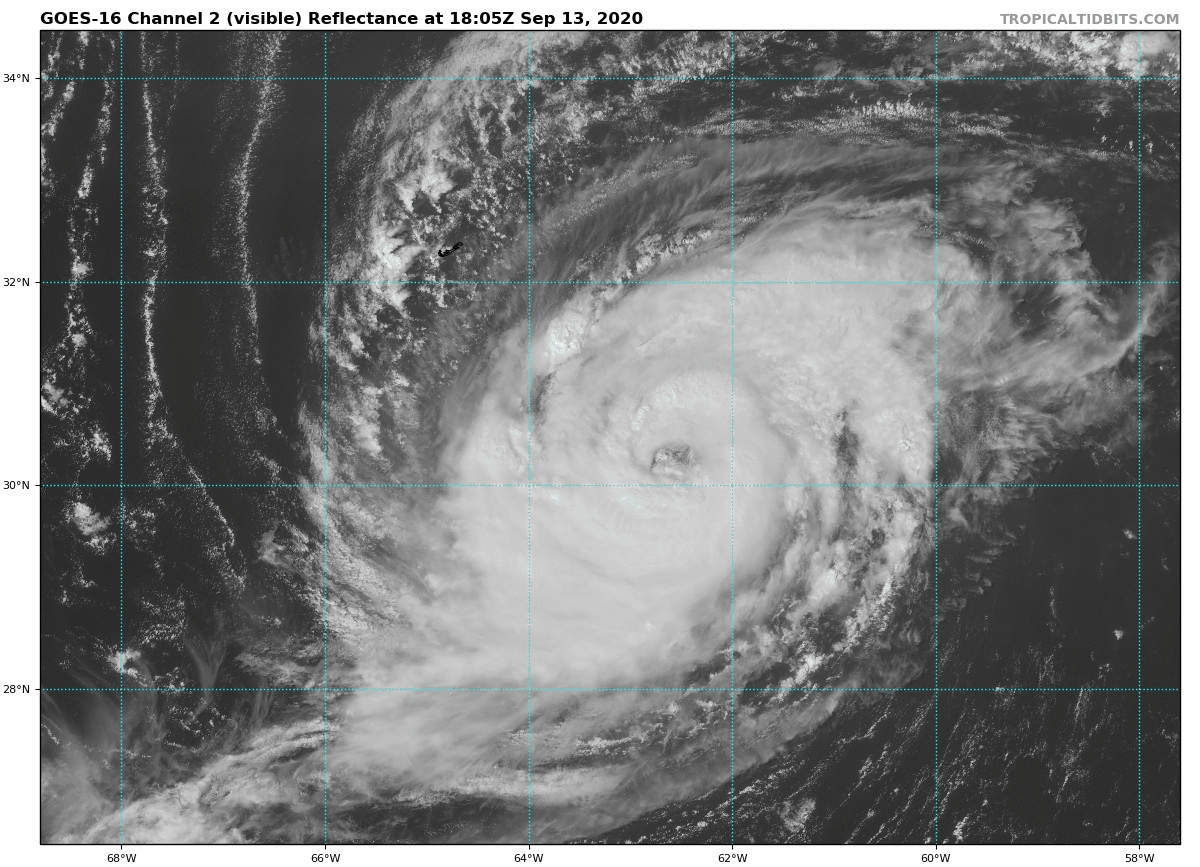
Hurricane Paulette is intensifying some this afternoon as it moves toward a rendezvous with Bemuuda early tomorrow. Tropical storm conditions will begin there shortly.
Top winds are now 85 mph. They should increase too near 100 mph around midnight and the center will pass near or just east of the island during the predawn hours.
Based on the current forecast, there is a good chance that Bermuda will experience the eyewall of the storm, with the passage of the eye around 4 AM CDT. Winds will each 100 mph with gusts to 120 mph. Winds will fall below hurricane force in the early morning and below tropical storm force by 4 p.m. CDT. Tropical gusts will continue into the evening.
Here is the 4 p.m. CDT advisory.
BULLETIN
Hurricane Paulette Advisory Number 28
NWS National Hurricane Center Miami FL AL172020
500 PM AST Sun Sep 13 2020
…TROPICAL STORM CONDITIONS EXPECTED TO REACH BERMUDA WITHIN THE
NEXT COUPLE OF HOURS…
…PREPARATIONS TO PROTECT LIFE AND PROPERTY NEED TO BE RUSHED TO
COMPLETION…
SUMMARY OF 500 PM AST…2100 UTC…INFORMATION
———————————————-
LOCATION…30.6N 63.1W
ABOUT 155 MI…250 KM SE OF BERMUDA
MAXIMUM SUSTAINED WINDS…85 MPH…140 KM/H
PRESENT MOVEMENT…NW OR 313 DEGREES AT 14 MPH…22 KM/H
MINIMUM CENTRAL PRESSURE…974 MB…28.77 INCHES
WATCHES AND WARNINGS
——————–
CHANGES WITH THIS ADVISORY:
None.
SUMMARY OF WATCHES AND WARNINGS IN EFFECT:
A Hurricane Warning is in effect for…
* Bermuda
A Hurricane Warning means that hurricane conditions are expected
somewhere within the warning area, in this case within the next
12 to 24 hours. Tropical-storm-force winds that make outside
preparations difficult or dangerous are expected to reach Bermuda
this afternoon or evening. Preparations to protect life and property
should be rushed to completion.
For storm information specific to your area, please monitor
products issued by your national meteorological service.
DISCUSSION AND OUTLOOK
———————-
At 500 PM AST (2100 UTC), the eye of Hurricane Paulette was located
near latitude 30.6 North, longitude 63.1 West. Paulette is moving
toward the northwest near 14 mph (22 km/h) and this motion is
expected to continue through tonight. A turn toward the north with a
decrease in forward speed is forecast on Monday, followed by a
faster northeastward motion Monday night and Tuesday. On the
forecast track, the center of Paulette will move near or over
Bermuda Monday morning.
Maximum sustained winds have increased to near 85 mph (140 km/h)
with higher gusts. Additional strengthening is forecast, and
Paulette is expected to be a dangerous hurricane when it approaches
Bermuda late tonight and early Monday. Some further strengthening
is possible when Paulette turns northeastward and moves away from
Bermuda late Monday through Monday night.
Hurricane-force winds extend outward up to 60 miles (95 km) from the
center and tropical-storm-force winds extend outward up to 175 miles
(280 km).
The estimated minimum central pressure is 974 mb (28.77 inches).
HAZARDS AFFECTING LAND
———————-
Key messages for Paulette can be found in the Tropical Cyclone
Discussion under AWIPS header MIATCDAT2, WMO header WTNT42 KNHC,
and on the web at www.hurricanes.gov/text/MIATCDAT2.shtml.
WIND: Hurricane conditions are expected to reach Bermuda
late tonight. Winds are expected to first reach tropical storm
strength within the next couple of hours, making outside
preparations difficult or dangerous. Preparations to protect life
and property should be rushed to completion.
STORM SURGE: A dangerous storm surge is expected to produce
significant coastal flooding on Bermuda in areas of onshore winds.
Near the coast, the surge will be accompanied by large and
destructive waves.
RAIN: Paulette will bring periods of heavy rain to Bermuda through
Monday, with rainfall of 3 to 6 inches expected.
SURF: Swells generated by Paulette are affecting portions of the
Leeward Islands, the Greater Antilles, the Bahamas, Bermuda, and the
east coast of the United States. These swells are likely to cause
life-threatening surf and rip current conditions. Please consult
products from your local weather office.
NEXT ADVISORY
————-
Next intermediate advisory at 800 PM AST.
Next complete advisory at 1100 PM AST.
$$
Forecaster Latto
About the Author (Author Profile)
Bill Murray is the President of The Weather Factory. He is the site's official weather historian and a weekend forecaster. He also anchors the site's severe weather coverage. Bill Murray is the proud holder of National Weather Association Digital Seal #0001 @wxhistorianSubscribe
If you enjoyed this article, subscribe to receive more just like it.


