


Here are observations from this morning from TXKF – LF Wade International Airport on the beautiful island nation of Bermuda.
They had a wind gust to 89 mph before an island-wide power failure crippled communications around sometime after 4 a.m. ADT (2 a.m. CDT). Their next report was just before 7 a.m. ADT when they reported a SW wind of 13 mph and a pressure of 972 mph. Next hour, the winds were gusting to 71 mph again.
Here was the 6 AM AST Tropica Cyclone Update:
Hurricane Paulette Tropical Cyclone Update
NWS National Hurricane Center Miami FL AL172020
600 AM AST Mon Sep 14 2020
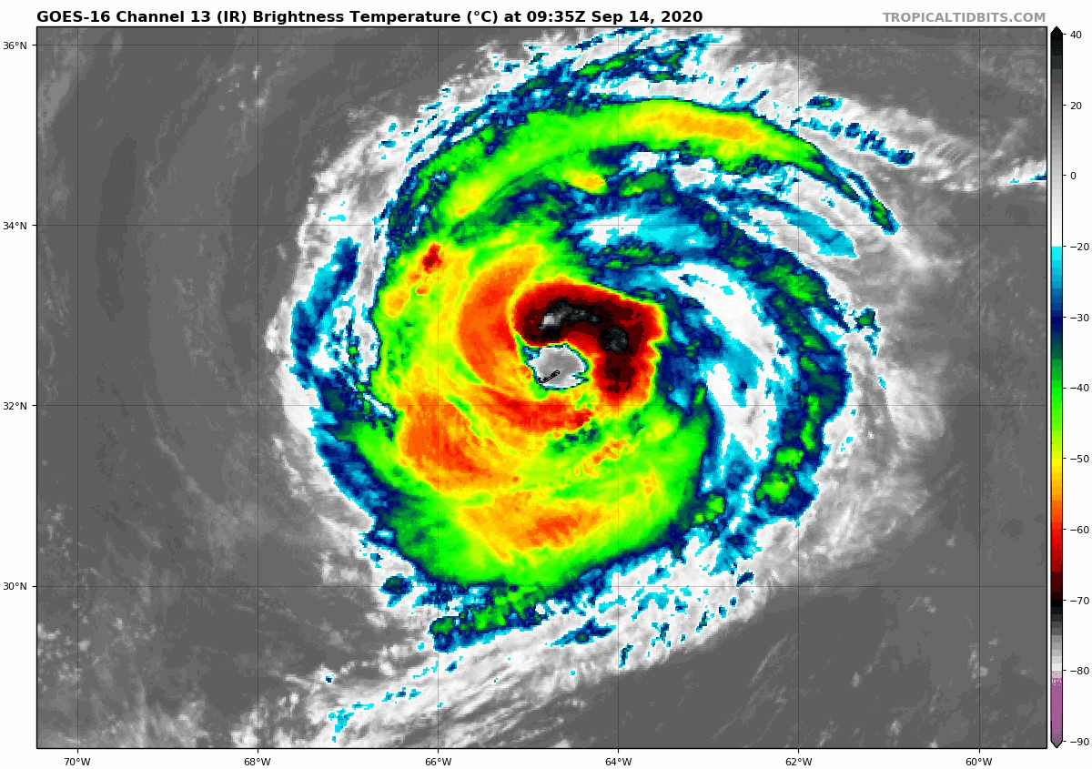
…ALL OF BERMUDA STILL IN THE EYE OF PAULETTE…
…STRONG DAMAGING WINDS AND TORRENTIAL RAINS WILL SOON AFFECT
BERMUDA FROM THE SOUTHWEST…
The eye of Paulette will move north-northwestward to northward this
morning, bringing the southern portion of the eyewall with
hurricane-force winds and torrential across the entire island of
Bermuda very soon.
All persons are urged to not venture outside until the storm passes
this afternoon as winds will increase suddenly from the southwest.
SUMMARY OF 600 AM AST…1000 UTC…INFORMATION
—————————————————
LOCATION…32.4N 64.7W
ABOUT 5 MI…10 KM N OF BERMUDA
MAXIMUM SUSTAINED WINDS…90 MPH…150 KM/H
PRESENT MOVEMENT…NNW OR 350 DEGREES AT 13 MPH…20 KM/H
MINIMUM CENTRAL PRESSURE…972 MB…28.70 INCHES
$$
Forecaster Stewart
Conditions will slowly improve there today.
Here is the 7 a.m. Advisory:
BULLETIN
Hurricane Paulette Intermediate Advisory Number 30A
NWS National Hurricane Center Miami FL AL172020
800 AM AST Mon Sep 14 2020
…EYE OF PAULETTE MOVING AWAY FROM THE ISLAND OF BERMUDA…
…HURRICANE-FORCE WINDS AND TORRENTIAL RAINS ASSOCIATED WITH THE
SOUTHERN EYEWALL AFFECTING THE ISLAND…
SUMMARY OF 800 AM AST…1200 UTC…INFORMATION
———————————————-
LOCATION…32.9N 64.7W
ABOUT 40 MI…65 KM N OF BERMUDA
MAXIMUM SUSTAINED WINDS…95 MPH…155 KM/H
PRESENT MOVEMENT…NNW OR 345 DEGREES AT 12 MPH…19 KM/H
MINIMUM CENTRAL PRESSURE…970 MB…28.64 INCHES
WATCHES AND WARNINGS
——————–
CHANGES WITH THIS ADVISORY:
None.
SUMMARY OF WATCHES AND WARNINGS IN EFFECT:
A Hurricane Warning is in effect for…
* Bermuda
A Hurricane Warning means that hurricane conditions are occurring
on Bermuda or will begin again in a couple of hours.
For storm information specific to your area, please monitor
products issued by your national meteorological service.
DISCUSSION AND OUTLOOK
———————-
At 800 AM AST (1200 UTC), the center of the eye of Hurricane
Paulette was located over northeastern Bermuda or near latitude 32.9
North, longitude 64.7 West. Paulette is moving toward the
north-northwest near 12 mph (19 km/h). A turn toward the north is
expected soon and should continue into this afternoon. A faster
motion toward the northeast is expected by this evening and
should continue through Wednesday.
Maximum sustained winds have increased to near 95 mph (155 km/h)
with higher gusts. Additional strengthening is likely when Paulette
turns northeastward and moves away from Bermuda tonight through
Tuesday.
Hurricane-force winds extend outward up to 45 miles (75 km) from
the center and tropical-storm-force winds extend outward up to 175
miles (280 km). Hurricane-force winds are returning as the southern
portion of Paulette’s eyewall continues to move over the island.
Tropical-storm-force winds will continue possibly into the early
afternoon across the entire island.
The estimated minimum central pressure based on hurricane
hunter aircraft and surface observations on Bermuda is 970 mb
(28.64 inches).
HAZARDS AFFECTING LAND
———————-
Key messages for Paulette can be found in the Tropical Cyclone
Discussion under AWIPS header MIATCDAT2, WMO header WTNT42 KNHC,
and on the web at www.hurricanes.gov/text/MIATCDAT2.shtml.
WIND: Hurricane conditions are returning to Bermuda from the south
and southwest as the southern eyewall passes over the island soon.
Hurricane conditions should subside around mid-morning, but
tropical storm conditions will persist into late-morning and
possibly early afternoon.
STORM SURGE: A dangerous storm surge is expected to produce
significant coastal flooding on Bermuda in areas of onshore winds.
Near the coast, the surge will be accompanied by large and
destructive waves into this afternoon.
RAIN: Paulette will bring periods of heavy rain to Bermuda through
today, with rainfall of 3 to 6 inches expected.
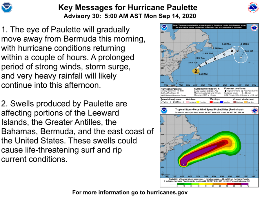
SURF: Swells generated by Paulette are affecting portions of the
Leeward Islands, the Greater Antilles, the Bahamas, Bermuda, and the
east coast of the United States. These swells are likely to cause
life-threatening surf and rip current conditions. Please consult
products from your local weather office.
NEXT ADVISORY
————-
Next complete advisory at 1100 AM AST.
The final Tropical Cyclone Update will be issued at 900 AM AST.
$$
Forecaster Roberts


