

A Check on the Tropics as of 10:00 pm
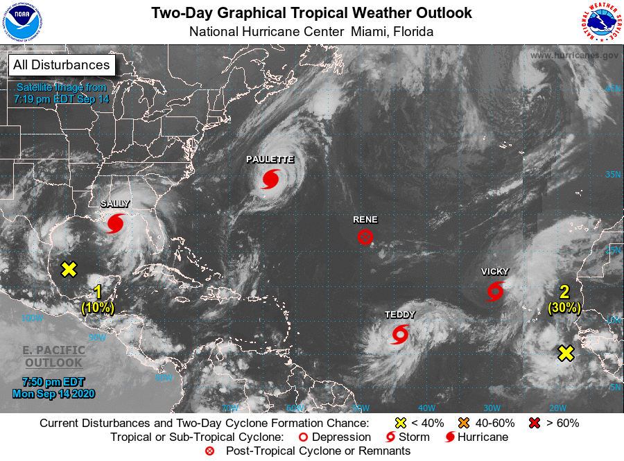
Hurricane Paulette is accelerating to the northeast as she is now 275 miles to the north-northeast of Bermuda. Winds are at 105 MPH and strengthening is possible Tuesday and early Wednesday. Rapid weakening is forecast to begin by late Wednesday and will likely continue through the rest of the week. No treat to any land.
Tropical Storm Vicky is a little stronger as of 10:00 pm, but she is expected to weaken and become a remnant low on Wednesday. Currently, winds are at 50 MPH and are moving to the northwest at 7 MPH. No threat to any land.
Tropical Storm Teddy is forecast to become a hurricane on Tuesday, but as of 10:00 pm, winds are at 50 MPH and is moving to the west at 13 MPH. The center is located around 1100 miles to the east of the Lesser Antilles and is expected to curve to the northwest and away from any land for a good while. Strengthening is forecast for the next several days. Teddy is expected to become a hurricane Tuesday and could reach major hurricane strength on Thursday.
Rene has dissipated and is no longer a watched area.
1. A broad area of low pressure over the southwestern Gulf of Mexico is currently producing little shower or thunderstorm activity. Any development of this system should be slow to occur while the low meanders over the southern Gulf of Mexico for the next several days.
• Formation chance through 48 hours…low…10 percent.
• Formation chance through 5 days…low…20 percent.
2. A tropical wave located over the far eastern tropical Atlantic continues to produce disorganized showers and thunderstorms. Some development of this system is possible, and a tropical depression could form during the next several days while the system moves generally westward at 10 to 15 mph.
• Formation chance through 48 hours…low…30 percent.
• Formation chance through 5 days…medium…50 percent.
About the Author (Author Profile)
Scott Martin is an operational meteorologist, professional graphic artist, musician, husband, and father. Not only is Scott a member of the National Weather Association, but he is also the Central Alabama Chapter of the NWA president. Scott is also the co-founder of Racecast Weather, which provides forecasts for many racing series across the USA. He also supplies forecasts for the BassMaster Elite Series events including the BassMaster Classic.Subscribe
If you enjoyed this article, subscribe to receive more just like it.


