

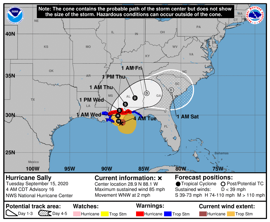
Hurricane Sally – Tuesday Morning Update
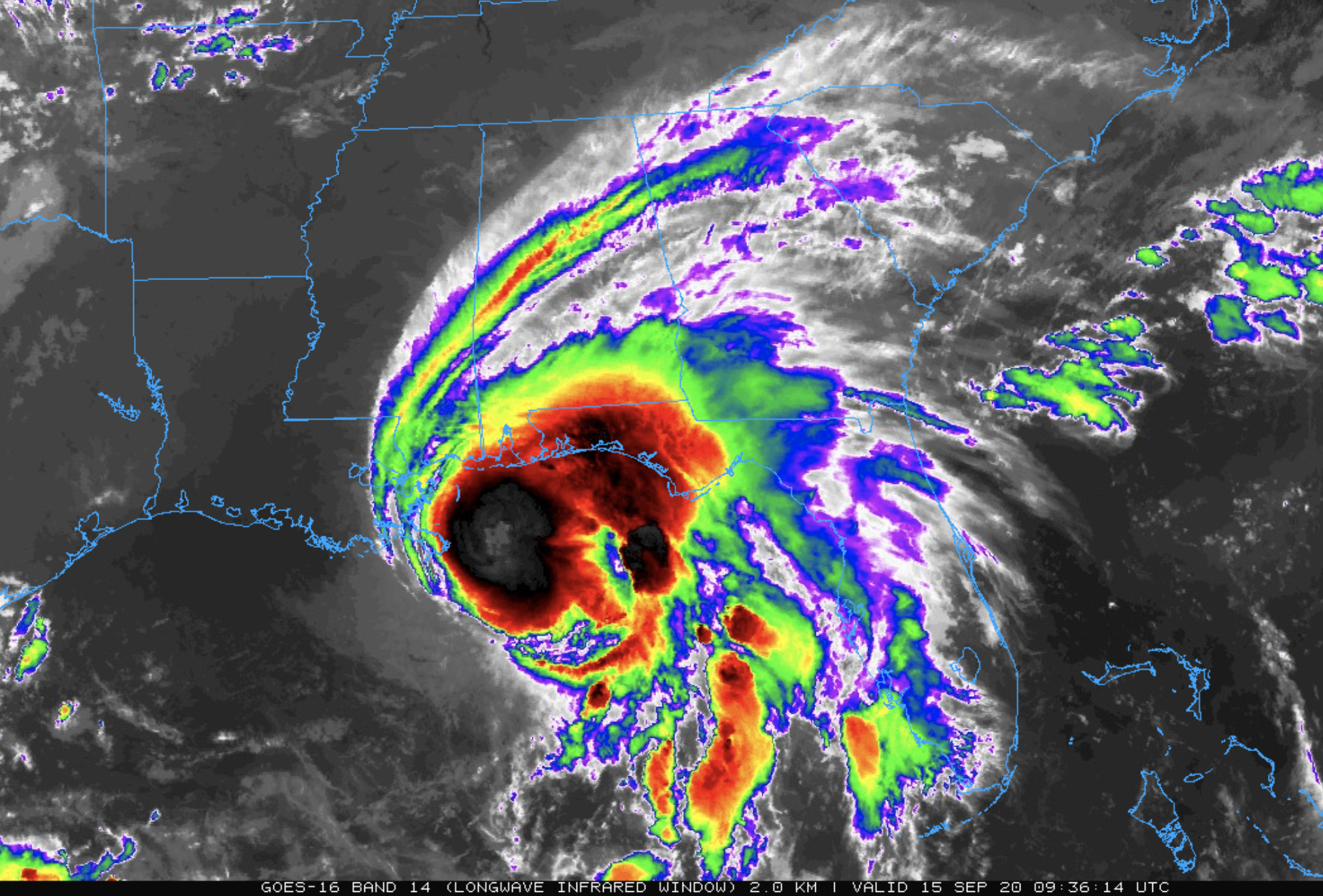
Hurricane Sally now has sustained winds of 85 mph, and is located about 115 miles south of Biloxi. It is practically stationary; drifting to the west/northwest at only 2 mph. Landfall is now expected tomorrow morning near the Mississippi/Alabama border at category one strength.
Don’t focus on the exact forecast track or the specific timing and location of landfall. Hurricane-force winds, dangerous storm surge, and flooding rainfall will affect a large portion of the north-central Gulf Coast during the next few days.
Sally is now expected to remain in a moderate to high mid-to upper-level wind shear environment. Ina addition, some modest upwelling is likely occurring in the inner-core region based a SST (sea surface temperature) decrease of nearly 2 deg F during the past 24 hours based on data from buoy 42012. This caused the weakening trend overnight.
A Storm Surge Warning is in effect for…
* Mouth of the Mississippi River to the Okaloosa/Walton County Line Florida
* Mobile Bay
A Hurricane Warning is in effect for…
* East of the Mouth of the Pearl River to the Navarre Florida
A Tropical Storm Warning is in effect for…
* East of Navarre Florida to Indian Pass Florida
* Mouth of the Pearl River westward to Grand Isle Louisiana, including Lake Pontchartrain and Lake Maurepas and metropolitan New Orleans
STORM SURGE: The combination of a dangerous storm surge and the tide will cause normally dry areas near the coast to be flooded by rising waters moving inland from the shoreline. The water could reach the following heights above ground somewhere in the indicated areas if the peak surge occurs at the time of high tide…
Mouth of the Mississippi River to Dauphin Island including Lake Borgne…6-9 ft
Mobile Bay…6-9 ft
Dauphin Island and the Alabama coast…4-7 ft
AL/FL Border to Okaloosa/Walton County Line including Pensacola Bay and Choctawhatchee Bay…2-4 ft
Lake Pontchartrain and Lake Maurepas…2-4 ft
Port Fourchon to Mouth of the Mississippi River…1-3 ft
Okaloosa/Walton County Line to Chassahowitzka including Saint Andrew Bay…1-3 ft
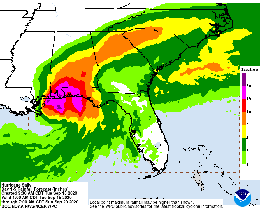
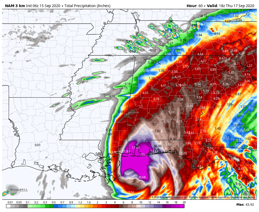
RAINFALL: Sally is expected to be a slow moving system as it approaches land producing 10 to 20 inches of rainfall with isolated amounts of 30 inches along and just inland of the central Gulf Coast from the western Florida Panhandle to far southeastern Mississippi. Historic flooding is possible with extreme life-threatening flash flooding likely through tomorrow. In addition, this rainfall will lead to widespread moderate to major flooding on area rivers.
Sally is forecast to turn inland early Wednesday and move across the Southeast producing rainfall of 4 to 8 inches, with isolated maximum amounts of 12 inches, across portions of southeastern Mississippi, southern and central Alabama, northern Georgia, and the western Carolinas. Significant flash and urban flooding is likely, as well as widespread minor to moderate flooding on some rivers.
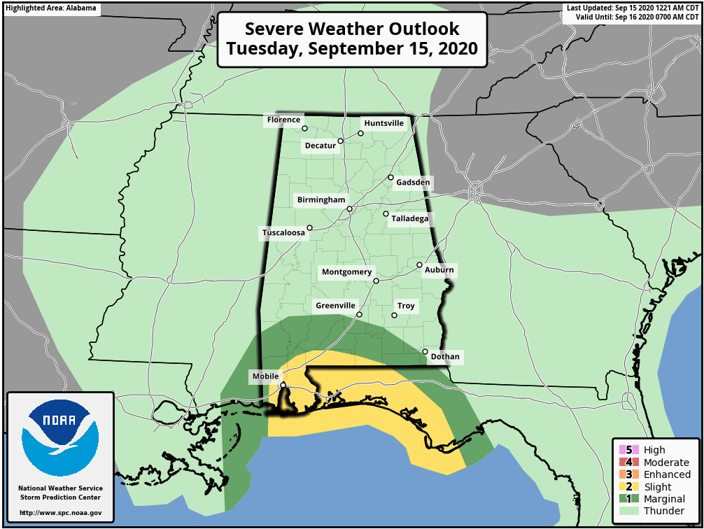
TORNADOES: A tornado or two will be possible this morning in coastal areas of the Florida Panhandle and Alabama. The tornado threat should increase and slowly spread inland the rest of today into Wednesday.
SURF: Swells from Sally will continue to affect the coast from the Florida Big Bend westward to southeastern Louisiana during the next couple of days. These swells are likely to cause life-threatening surf and rip current conditions.
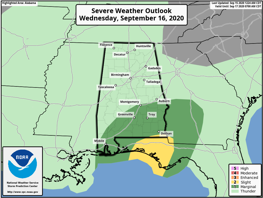
INLAND ALABAMA: For North/Central Alabama, today will be fairly quiet with only isolated showers. Rain will become widespread during the day tomorrow, mainly south of U.S. 278 (south of a line from Hamilton to Cullman to Gadsden). A flash flood watch is in effect from I-20 south (Tuscaloosa to Birmingham to Anniston); rain amounts across the central and southern counties of the state will range from 2 to 8 inches with the highest totals roughly around the I-85 corridor (Montgomery to Opelika).
There will be a sharp drop in rain totals north of I-59, most likely.
Tomorrow will be windy; winds of 15-30 mph are likely over the southern 2/3 of the state. We do not expect widespread tree and power line damage, or major power outages. A few isolated, brief tornadoes are possible south of a line from Mobile to Montgomery to Opelika, with the higher probabilities across Southeast Alabama.
The rain will end from west to east during the day Thursday.
As always, this forecast could change, so stay tuned for updates!
Category: Alabama's Weather, ALL POSTS, Tropical
About the Author (Author Profile)
James Spann is one of the most recognized and trusted television meteorologists in the industry. He holds the AMS CCM designation and television seals from the AMS and NWA. He is a past winner of the Broadcast Meteorologist of the Year from both professional organizations.Subscribe
If you enjoyed this article, subscribe to receive more just like it.


