

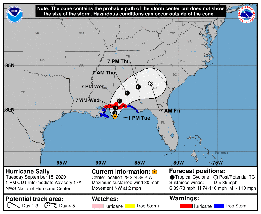
1:00 pm Update: Sally Inching Its Way Toward the Northern Gulf Coast
SUMMARY OF 100 PM CDT…1800 UTC…INFORMATION
———————————————-
LOCATION…29.2N 88.2W
ABOUT 60 MI…95 KM E OF THE MOUTH OF THE MISSISSIPPI RIVER
ABOUT 105 MI…165 KM S OF MOBILE ALABAMA
MAXIMUM SUSTAINED WINDS…80 MPH…130 KM/H
PRESENT MOVEMENT…NW OR 325 DEGREES AT 2 MPH…4 KM/H
MINIMUM CENTRAL PRESSURE…982 MB…29.00 INCHES
WATCHES AND WARNINGS
——————–
A Storm Surge Warning is in effect for…
• Mouth of the Mississippi River to the Okaloosa/Walton County Line Florida
• Mobile Bay
A Hurricane Warning is in effect for…
• East of Bay St. Louis to Navarre Florida
A Tropical Storm Warning is in effect for…
• East of Navarre Florida to Indian Pass Florida
• Bay St. Louis westward to Grand Isle Louisiana
DISCUSSION AND OUTLOOK
———————-
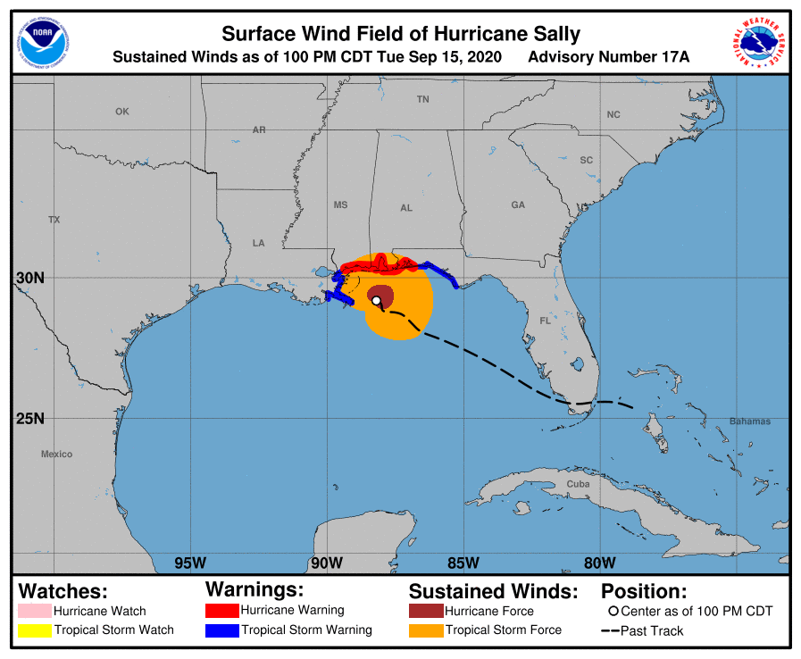
At 100 PM CDT (1800 UTC), the center of Hurricane Sally was located near latitude 29.2 North, longitude 88.2 West. Sally is moving toward the northwest near 2 mph (4 km/h). A slow north-northwestward to northward motion is expected this afternoon, followed by a slow northward to north-northeastward motion tonight through Wednesday night. On the forecast track, the center of Sally will pass near the coast of southeastern Louisiana today, and make landfall in the hurricane warning area late tonight or Wednesday.
Maximum sustained winds are near 80 mph (130 km/h) with higher gusts. Although little change in strength is forecast until landfall occurs, Sally is still expected to be a dangerous hurricane when it moves onshore along the north-central Gulf Coast.
Hurricane-force winds extend outward up to 45 miles (75 km) from the center and tropical-storm-force winds extend outward up to 125 miles (205 km). An NOAA buoy located about 50 miles (80 km) southeast of Mobile, Alabama, recently reported sustained winds of 56 mph (90 km/h) and a gust to 67 mph (108 km/h) within the past few hours. A weather station at Dauphin Island, Alabama, recently reported sustained winds of 45 mph (72 km/h) and a gust to 59 mph (95 km/h).
The latest minimum central pressure reported by an NOAA Hurricane Hunter aircraft is 982 MB (29.00 inches).
HAZARDS AFFECTING LAND
———————-
STORM SURGE: The combination of a dangerous storm surge and the tide will cause normally dry areas near the coast to be flooded by rising waters moving inland from the shoreline. The water could reach the following heights above ground somewhere in the indicated areas if the peak surge occurs at the time of high tide…
• MS/AL Border to AL/FL Border including Mobile Bay…4-7 ft
• The mouth of the Mississippi River to the Mouth of the Pearl River including Lake Borgne…4-6 ft
• The mouth of the Pearl River to MS/AL Border…3-5 ft
• AL/FL Border to Okaloosa/Walton County Line, FL including Pensacola Bay and Choctawhatchee Bay…3-5 ft
• Lake Pontchartrain and Lake Maurepas…2-4 ft
• Okaloosa/Walton County Line, FL to Chassahowitzka, FL including Saint Andrews Bay…1-3 ft
• Grand Isle, LA to Mouth of the Mississippi River…1-3 ft
The deepest water will occur along the immediate coast in areas of onshore winds, where the surge will be accompanied by large and damaging waves. Surge-related flooding depends on the relative timing of the surge and the tidal cycle and can vary greatly over short distances.
WIND: Hurricane conditions are expected to begin within the hurricane warning area later today or tonight. Tropical storm conditions are already occurring in portions of the warning areas, and these conditions will continue through Wednesday night.
RAINFALL: Sally is forecast to produce 10 to 20 inches of rainfall with isolated amounts of 30 inches along and just inland of the central Gulf Coast from the western Florida Panhandle to far southeastern Mississippi. Historic flooding is likely with extreme life-threatening flash flooding likely through Wednesday. In addition, this rainfall will lead to widespread moderate to major flooding on area rivers.
Sally is forecast to move inland Wednesday and track across the Southeast producing rainfall of 4 to 8 inches, with isolated maximum amounts of 12 inches, across portions of southeastern Mississippi, southern and central Alabama, northern Georgia, and the western Carolinas. Significant flash and urban flooding is likely, as well as widespread minor to moderate flooding on some rivers.
TORNADOES: Isolated tornadoes may occur today through Wednesday across portions of the Florida Panhandle and southern Alabama.
SURF: Swells from Sally will continue to affect the coast from the Florida Big Bend westward to southeastern Louisiana during the next couple of days. These swells are likely to cause life-threatening surf and rip current conditions.
Category: Alabama's Weather, ALL POSTS, Severe Weather, Tropical
About the Author (Author Profile)
Scott Martin is an operational meteorologist, professional graphic artist, musician, husband, and father. Not only is Scott a member of the National Weather Association, but he is also the Central Alabama Chapter of the NWA president. Scott is also the co-founder of Racecast Weather, which provides forecasts for many racing series across the USA. He also supplies forecasts for the BassMaster Elite Series events including the BassMaster Classic.Subscribe
If you enjoyed this article, subscribe to receive more just like it.


