

Sally Slowly Moves Inland Tomorrow Morning
EYES ON THE GULF: Hurricane Sally will dominate the Alabama weather situation through Thursday. The hurricane continues to slowly weaken in terms of wind; sustained winds are now 80 mph, and it will be a minimal hurricane when the center moves inland on the Alabama coast early tomorrow morning. Forward movement this afternoon is only 2 mph… upwelling from the nearly stationary hurricane has helped in the weakening trend, along with stronger winds aloft creating shear.

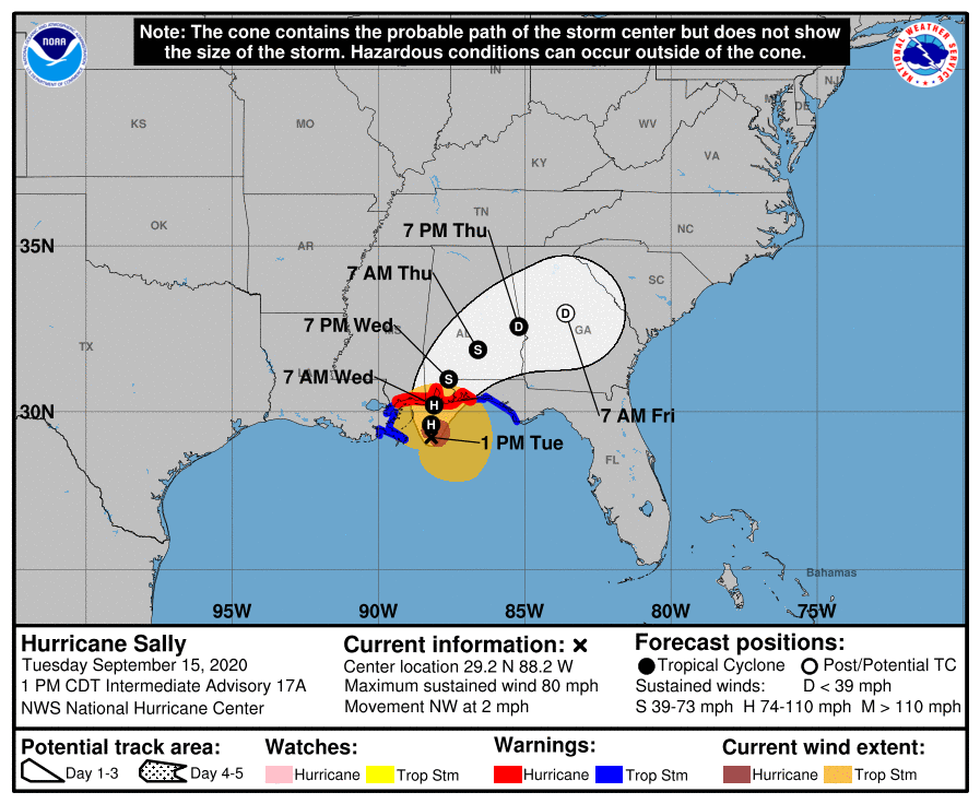
The biggest issue from Sally won’t be wind, but the rain and associated flooding threat. Rain amounts could approach two feet in spots along the Gulf Coast from Dauphin Island over to Navarre Beach by tomorrow.
We also note a tornado watch remains in effect for Mobile and Baldwin counties and most of the Florida Panhandle until 6p CT; another watch will likely be issued to replace it tonight.
Over the northern half of the state, the weather remain quiet this afternoon with only isolated showers.
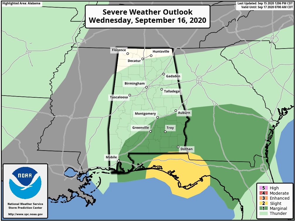
TOMORROW: Sally will begin to turn northeast across South Alabama; the day will be windy and very wet for most of the state. A flash flood watch remains in effect for I-20 and points south, or along and south of a line from Tuscaloosa to Birmingham to Anniston. Rain amounts close to I-20 will be in the 1-3 inch range, with heavier totals over the southern half of the state. South Alabama will see rain totals of 6-10 inches in most places.
In terms of gradient wind, areas south of U.S. 80 (the southern half of Alabama) will see winds of 20-30 mph, with a few gusts to 40 mph. For the northern half of the state, winds will be 15-25 mph with gusts to 30. We are not expecting major tree and power line damage, or widespread power outages.
We will have the threat of a few isolated tornadoes mainly across Southeast Alabama during the day tomorrow, especially during the afternoon when the air will be a little more unstable.
The rain will end from west to east Thursday morning as the remnant circulation moves through Georgia and toward the Carolinas.
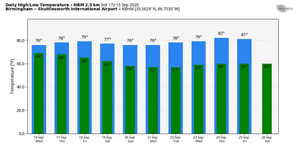
FRIDAY AND THE WEEKEND: The weather looks excellent on these three days. Mostly sunny pleasant days, lower humidity, and fair cool nights. Highs will be close to 80 on Friday, and in the upper 70s over the weekend. Lows will drop into the low 60s early Friday and Saturday morning, and into the 50s Sunday morning. It will feel like fall.
NEXT WEEK: The delightful weather continues through at least the first half of the week; a cold front could bring a few showers by Thursday or Friday, but it doesn’t look like a major rain event. See the Weather Xtreme video for maps, graphics, and more details.
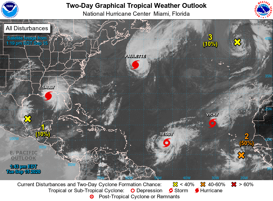
REST OF THE TROPICS: Hurricane Paulette is headed into the North Atlantic, and will become post-tropical soon. Tropical Storm Teddy is forecast to become a major hurricane later this week; those on the island of Bermuda will need to watch this one closely, but it will recurve into the open Atlantic well east of the U.S. Tropical Storm Vicky, in the eastern Atlantic, is far from land and will be short lived.
A tropical wave in the eastern Atlantic has a high chance of becoming Tropical Storm Wilfred within the next five days; long range data from models suggests this will gain latitude in time and most likely won’t impact the U.S.
ON THIS DATE IN 1945: A hurricane entered the south Florida coast at Homestead, curving northward right up through the center of Florida, remaining over land, and exited near Jacksonville Beach with winds gusting to 170 mph. The following is from the Homestead Air Reserve Base. “On Sept. 15, 1945, three years to the day after the founding of the Homestead Army Air Field, a massive hurricane roared ashore, sending winds of up to 145 miles per hour tearing through the Air Field’s buildings. Enlisted housing facilities, the nurses’ dormitory, and the Base Exchange were all destroyed. The roof was ripped from what would later become building 741, the Big Hangar. The base laundry and fire station were both declared total losses. The few remaining aircraft were tossed about like leaves.”
BEACH FORECAST: Click here to see the AlabamaWx Beach Forecast Center page.
WEATHER BRAINS: Don’t forget you can listen to our weekly 90 minute show anytime on your favorite podcast app. This is the show all about weather featuring many familiar voices, including our meteorologists here at ABC 33/40.
CONNECT: You can find me on all of the major social networks…
Facebook
Twitter
Instagram
Pinterest
Snapchat: spannwx
Look for the next Weather Xtreme video here by 7:00 a.m. tomorrow…
Category: Alabama's Weather, ALL POSTS, Weather Xtreme Videos
About the Author (Author Profile)
James Spann is one of the most recognized and trusted television meteorologists in the industry. He holds the AMS CCM designation and television seals from the AMS and NWA. He is a past winner of the Broadcast Meteorologist of the Year from both professional organizations.Subscribe
If you enjoyed this article, subscribe to receive more just like it.


