

Flood Advisory Until 9:00 pm for Lowndes, Montgomery, Barbour, & Bullock Co.
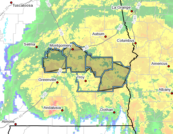
Flood Advisory
National Weather Service Birmingham AL
303 PM CDT Wed Sep 16 2020
The National Weather Service in Birmingham has issued a
* Urban and Small Stream Flood Advisory for…
Lowndes County in south central Alabama…
Montgomery County in south central Alabama…
Barbour County in southeastern Alabama…
Bullock County in southeastern Alabama…
* Until 900 PM CDT.
* At 303 PM CDT, Doppler radar indicated heavy rain due to Tropical
Storm Sally. This will cause urban and small stream flooding.
Between 2 and 4 inches of rain have fallen.
Some locations that will experience flooding include…
Montgomery, Eufaula, Union Springs, Clio, Mosses, Hayneville,
Midway, Meadville, Pike Road, Clayton, Coosada, White Hall,
Louisville, Gordonville, Lowndesboro, Blue Springs, Shopton, Pine
Level, Beans Crossroads and Franklin Field.
Additional rainfall is expected over the area. This additional rain
will result in minor flooding.
PRECAUTIONARY/PREPAREDNESS ACTIONS…
Turn around, don’t drown when encountering flooded roads. Most flood
deaths occur in vehicles.
Category: Alabama's Weather, ALL POSTS, Severe Weather, Tropical
About the Author (Author Profile)
Scott Martin is an operational meteorologist, professional graphic artist, musician, husband, and father. Not only is Scott a member of the National Weather Association, but he is also the Central Alabama Chapter of the NWA president. Scott is also the co-founder of Racecast Weather, which provides forecasts for many racing series across the USA. He also supplies forecasts for the BassMaster Elite Series events including the BassMaster Classic.Subscribe
If you enjoyed this article, subscribe to receive more just like it.


