

What’s Up with Teddy and Wilfred at 10:00 pm
POWERFUL HURRICANE TEDDY CONTINUES NORTHWESTWARD
RIP CURRENTS WILL AFFECT MOST WESTERN ATLANTIC COASTS THROUGH THE WEEKEND
SUMMARY OF 1100 PM AST…0300 UTC…INFORMATION
———————————————–
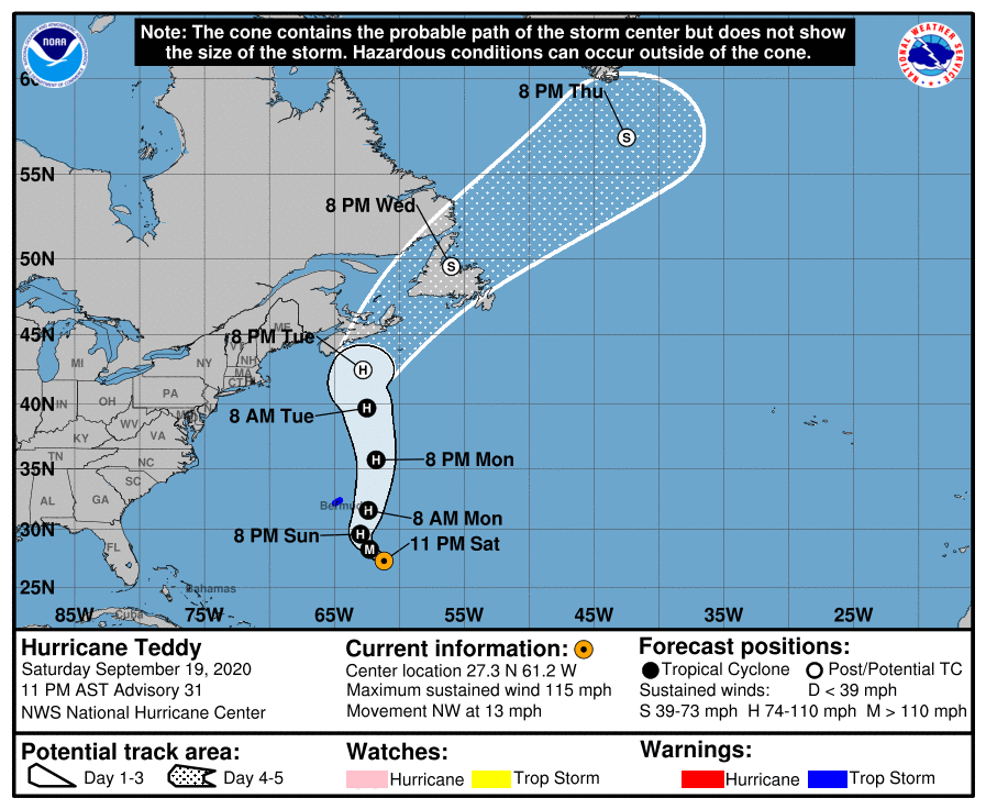
LOCATION…27.3N 61.2W
ABOUT 405 MI…655 KM SSE OF BERMUDA
MAXIMUM SUSTAINED WINDS…115 MPH…185 KM/H
PRESENT MOVEMENT…NW OR 315 DEGREES AT 13 MPH…20 KM/H
MINIMUM CENTRAL PRESSURE…956 MB…28.23 INCHES
At 1100 PM AST (0300 UTC), the center of Hurricane Teddy was located near latitude 27.3 North, longitude 61.2 West. Teddy is moving toward the northwest near 13 mph (20 km/h), and this general motion is expected to continue into Sunday. A turn toward the north is expected by Sunday night followed by a faster northward motion early next week. On the forecast track, Teddy will approach Bermuda on Sunday night, and the center will pass just east of the island Monday morning.
Data from an Air Force Reserve Hurricane Hunter aircraft indicate that maximum sustained winds are near 115 mph (185 km/h) with higher gusts. Teddy is a category 3 hurricane on the Saffir-Simpson Hurricane Wind Scale. A weakening trend is expected to begin Sunday night. Hurricane-force winds extend outward up to 60 miles (95 km) from the center and tropical-storm-force winds extend outward up to 255 miles (405 km). Teddy’s wind field is likely to become even larger over the next few days.
While the center of Teddy is forecast to move east of Bermuda late Sunday or Monday, tropical storm conditions are likely on the island beginning Sunday evening. Teddy is expected to transition to a powerful post-tropical cyclone as it moves near or over portions of Atlantic Canada early next week, where there is an increasing risk of direct impacts from wind, rain, and storm surge. Residents there should closely monitor the progress of Teddy and updates to the forecast.
Large swells produced by Teddy are expected to affect portions of the Leeward Islands, the Greater Antilles, the Bahamas, Bermuda, the east coast of the United States, and Atlantic Canada during the next few days. These swells could cause life-threatening surf and rip current conditions.
WILFRED CONTINUES WEST-NORTHWESTWARD WITH NO CHANGE IN STRENGTH
SUMMARY OF 1100 PM AST…0300 UTC…INFORMATION
———————————————–
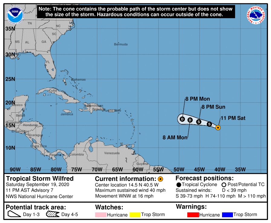
LOCATION…14.5N 40.5W
ABOUT 1105 MI…1775 KM W OF THE CABO VERDE ISLANDS
ABOUT 1390 MI…2235 KM E OF THE LESSER ANTILLES
MAXIMUM SUSTAINED WINDS…40 MPH…65 KM/H
PRESENT MOVEMENT…WNW OR 295 DEGREES AT 16 MPH…26 KM/H
MINIMUM CENTRAL PRESSURE…1007 MB…29.74 INCHES
At 1100 PM AST (0300 UTC), the center of Tropical Storm Wilfred was located near latitude 14.5 North, longitude 40.5 West. Wilfred is moving toward the west-northwest near 16 mph (26 km/h), and this general motion is expected to continue through Sunday, followed by a slower westward motion late Sunday and Monday. Maximum sustained winds are near 40 mph (65 km/h) with higher gusts. Little change in strength is expected through Sunday. Gradual Weakening is expected Sunday night and Monday, and Wilfred is expected to dissipate by Tuesday.
Category: ALL POSTS, Severe Weather, Tropical
About the Author (Author Profile)
Scott Martin is an operational meteorologist, professional graphic artist, musician, husband, and father. Not only is Scott a member of the National Weather Association, but he is also the Central Alabama Chapter of the NWA president. Scott is also the co-founder of Racecast Weather, which provides forecasts for many racing series across the USA. He also supplies forecasts for the BassMaster Elite Series events including the BassMaster Classic.Subscribe
If you enjoyed this article, subscribe to receive more just like it.


