

Wet in the North, Mostly Dry to the South Just After Midday; Marginal Risk Continues
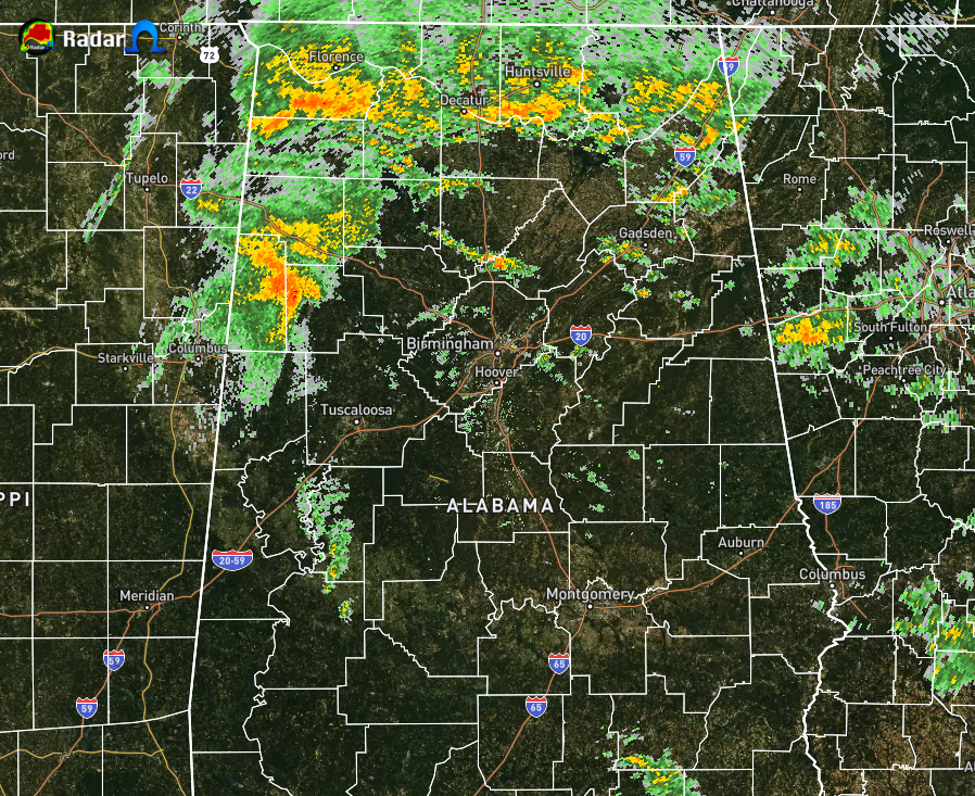
Radar check at 1:11 pm shows much of the heavier rain activity associated with the remnants of Beta continues to slowly move over much of North Alabama and into the northwest and western parts of Central Alabama. Much of the rest of Central Alabama is mostly dry at this point. Temperatures as of the 1:00 pm roundup were in the mid-60s to the upper 70s. Haleyville had light rain and was at 64 degrees as the cool spot. Troy had cloudy skies and was at 79 degrees as the warm spot. Birmingham was at 69 degrees with cloudy skies.
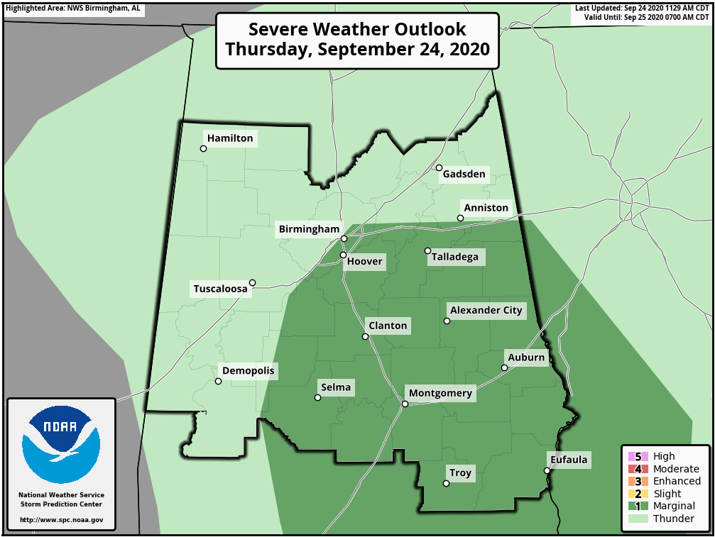
While the Marginal Risk area had been modified, it continues for locations east of a line from just west of Central Mills (Dallas Co.) to Little Hope (Bibb Co.) to Birmingham, then south of a line from Trussville (Jefferson Co.) to Heflin (Cleburne Co.). The threat for stronger to severe storms will persist across the risk area from now through 8:00 pm tonight. Damaging winds up to 60 MPH and a brief spin-up tornado are the main threats.
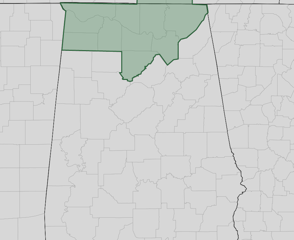
A Flash Flood Watch continues for Colbert, Cullman, Franklin, Jackson, Lauderdale, Lawrence, Limestone, Madison, Marshall, and Morgan counties in North Alabama until 7:00 pm tonight. Periods of moderate to heavy rainfall associated with the remnants of Tropical Storm Beta will impact the Tennessee Valley today. Efficient tropical rainfall rates will likely overpower absorption rates into the ground, leading to flash flooding across the area. No counties in Central Alabama are under a flash flood watch.
So for the rest of today, we’ll have periods of showers and maybe a few embedded thunderstorms, some of which may become strong to severe with the potential of isolated damaging wind gusts or a brief spin-up tornado for the areas defined in the Marginal Risk. Heavier rainfall can be expected over the extreme northern and northwestern parts of the area from now through tonight. Highs will be in the upper 60s to the lower 80s across the area. Rain will continue to be likely over the northeastern quarter of the area through the late night and overnight hours as the effects from Beta start to pull to the northeast. Rain chances will start to decrease for the western and southwestern parts of the area, but some patchy dense fog may develop in those areas. Lows will be in the lower 60s to the lower 70s.
FRIDAY’S WEATHER
Shower chances will continue to diminish during the morning and the rest of the day will be dry for the western half of Central Alabama. We can’t rule out a few isolated showers over the eastern parts of the area during the afternoon. All of Central Alabama should be dry by sunset and clouds will start to decrease. Afternoon highs will warm up into the lower 70s to the lower 80s across the area. Temperatures will fall into the 70s at 6:00 pm, into the upper 60s to the lower 70s by 10:00 pm, and eventually into the lower to mid-60s for the overnight low.
Category: Alabama's Weather, ALL POSTS, Severe Weather
About the Author (Author Profile)
Scott Martin is an operational meteorologist, professional graphic artist, musician, husband, and father. Not only is Scott a member of the National Weather Association, but he is also the Central Alabama Chapter of the NWA president. Scott is also the co-founder of Racecast Weather, which provides forecasts for many racing series across the USA. He also supplies forecasts for the BassMaster Elite Series events including the BassMaster Classic.Subscribe
If you enjoyed this article, subscribe to receive more just like it.


