

Showers And A Few Strong Storms Later Today; Much Cooler Tomorrow
COLD FRONT ON THE WAY: A cold front will push into Alabama later today, and will bring a band of showers and thunderstorms to the state. A few of the storms could be strong this afternoon; SPC has much of the state in a low end “marginal risk” (level 1/5)….
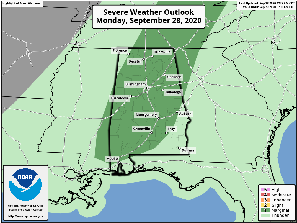
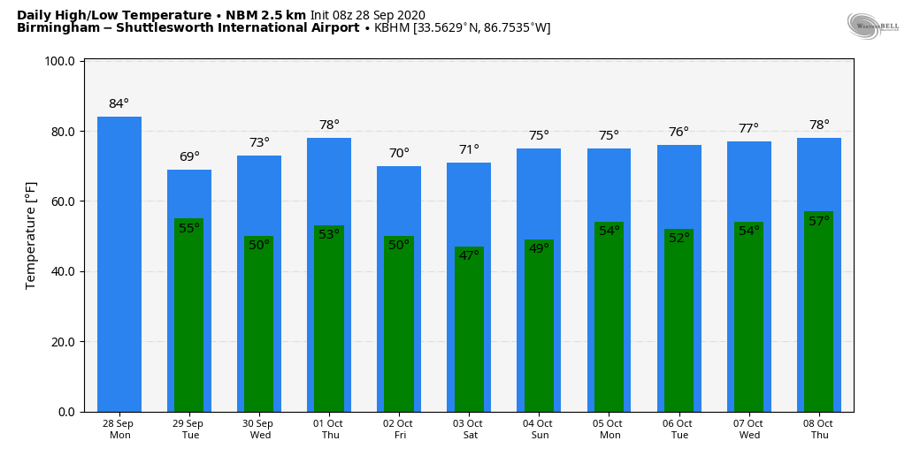
Heavier storms this afternoon could produce strong gusty winds; we do not expect any tornadoes. Otherwise, the sky will be mostly cloudy with a high in the mid to upper 70s this afternoon. The average high for Birmingham on September 28 is 81.
Tomorrow will be a mostly cloudy and much cooler day; the high will be only in the 68-71 degree range over the northern counties of Alabama with a cool northwest breeze of 10-18 mph. Some patchy light rain is possible over the northern third of the state under a cold core upper trough setting up over the eastern third of the nation.
WEDNESDAY THROUGH FRIDAY: Expect picture perfect autumn weather. Sunny pleasant days, clear cool nights. The high will be in the mid 70s Wednesday and Thursday, but closer to 70 on Friday as a secondary push of cool air arrives. Lows will be in the upper 40s and low 50s for most communities.
THE ALABAMA WEEKEND: Saturday morning will bring the coolest temperatures so far this season; lows will be in the 40s, and a few of the colder valleys across North Alabama could reach the upper 30s. Expect a sunny sky both days with a high in the low 70s Saturday, followed by mid to upper 70s Sunday.
NEXT WEEK: Quiet, mostly dry weather continues across the Deep South. Highs will be generally in the 70s; lows in the 50s. See the Weather Xtreme video for maps, graphics, and more details.
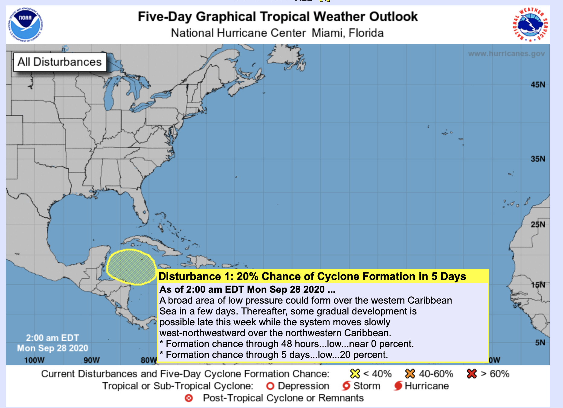
TROPICS: The Atlantic basin remains very quiet this week, but NHC does highlight the western Caribbean for some development potential in five days or so. The hurricane season runs through the end of November.
ON THIS DATE IN 1998: Hurricane Georges made landfall near Biloxi, Mississippi with maximum winds of 110 mph and a minimum pressure of 964 mb, making it a Category 2 hurricane. Georges produced a 7-12 foot storm surge in Mobile and Baldwin Counties with a 5-10 foot storm surge across the western Florida Panhandle, which caused extensive damage across coastal communities. The surge on the west end of Dauphin Island caused the most damage across the area. 80 houses were damaged on Dauphin Island and nearly 40 were completely destroyed. Many gulf front homes on the west end of the island were pushed across the island and ended up either against other homes or scattered across the sand.
BEACH FORECAST: Click here to see the AlabamaWx Beach Forecast Center page.
WEATHER BRAINS: Don’t forget you can listen to our weekly 90 minute show anytime on your favorite podcast app. This is the show all about weather featuring many familiar voices, including our meteorologists here at ABC 33/40.
CONNECT: You can find me on all of the major social networks…
Facebook
Twitter
Instagram
Pinterest
Snapchat: spannwx
Look for the next Weather Xtreme video here by 4:00 this afternoon… enjoy the day!
Category: Alabama's Weather, ALL POSTS, Weather Xtreme Videos
About the Author (Author Profile)
James Spann is one of the most recognized and trusted television meteorologists in the industry. He holds the AMS CCM designation and television seals from the AMS and NWA. He is a past winner of the Broadcast Meteorologist of the Year from both professional organizations.Subscribe
If you enjoyed this article, subscribe to receive more just like it.


