

Midday Nowcast: Gradually Clearing Sky this Afternoon
Frontal passage occurred yesterday and last night across Alabama, and you can certainly notice that cooler air mass settling into the state as temperatures are struggling to climb out of the 60s in many locations today. Through the morning we have been dealing with clouds and scattered areas of rain.
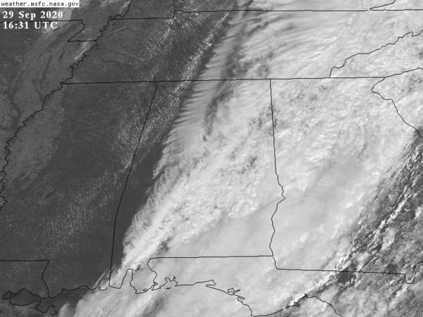
As we approach the midday hour, the clearing line is working into far West Alabama, and as we head through the afternoon hours, the rain will to continue to taper off, and the sky will continue to gradually clear from west to east across the state, which will allow for a fair amount of sun in spots this afternoon. In locations which see more sun, highs should make into the lower 70s, while 60s are expected where the clouds linger. Tonight will feature a clear sky and chilly temps with lows in the upper 40s and lower 50s across North/Central Alabama by first thing tomorrow morning.
PHENOMENAL FALL WEATHER: Tomorrow through Friday, expect sunny and pleasant days with highs in the low to mid-70s. Nights will be clear and cool with lows in the upper 40s and low 50s for most communities. On Friday, a secondary surge of cooler air arrives, setting the stage for an outstanding first weekend of October.
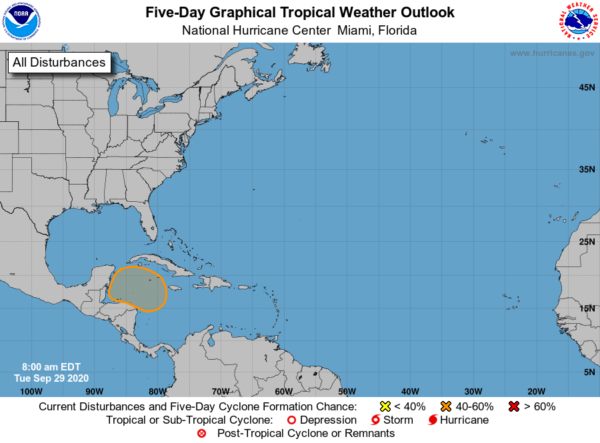
IN THE TROPICS: All is quiet to start this week, by the end of the week, there could be one area of concern. A broad area of low pressure is expected to form over the western Caribbean Sea in a few days. Environmental conditions are forecast to be conducive for some development thereafter, and a tropical depression could form late this week or this weekend while the system moves slowly west-northwestward over the northwestern Caribbean Sea. Formation chance through 5 days…medium…50 percent. Remember hurricane season runs through the end November and the next name up is Gamma.
BEACH FORECAST CENTER: Get the latest weather and rip current forecasts for the beaches from Fort Morgan to Panama City on our Beach Forecast Center page. There, you can select the forecast of the region that you are interested in visiting.
WORLD TEMPERATURE EXTREMES: Over the last 24 hours, the highest observation outside the U.S. was 114.8F at Yenbo, Saudi Arabia. The lowest observation was -86.4F at Amundsen-Scott South Pole Station, Antarctica.
CONTIGUOUS TEMPERATURE EXTREMES: Over the last 24 hours, the highest observation was 108F at Palm Springs and Thermal, CA. The lowest observation was 7F at Grand Lake, CO.
WEATHER ON THIS DATE IN 1983: Heavy rains began in central and eastern Arizona which culminated in the worst flood in the history of the state. Eight to ten inch rains across the area caused severe flooding in southeastern Arizona which resulted in thirteen deaths and 178 million dollars damage. President Reagan declared eight counties of Arizona to be disaster areas.
Category: Alabama's Weather, ALL POSTS
About the Author (Author Profile)
Macon, Georgia Television Chief Meteorologist, Birmingham native, and long time Contributor on AlabamaWX. Stormchaser. I did not choose Weather, it chose Me. College Football Fanatic. @Ryan_StinnetSubscribe
If you enjoyed this article, subscribe to receive more just like it.


