


THE CENTRAL ALABAMA WEEKEND
Get ready for a super weekend across Central Alabama with tons of sunshine and nice and mild temperatures. After cool mornings, Saturday’s highs will be in the lower to mid-70s and reaching the mid to upper 70s on Sunday. One or two locations may briefly reach 80 degrees on Sunday.
THE WORK WEEK AHEAD
Great weather will continue through the entire workweek ahead with temperatures warming just a little before taking a very small step backward at the end of the week. We will have plenty of sunshine each day, but a potential tropical system moves up from the Caribbean at the end of the week, and we may have some clouds move northward into Central Alabama. At this point, no rain will invade the area through Friday night. Highs will start off in the mid to upper 70s on Monday, maxing out in the upper 70s to the mid-80s on Wednesday and Thursday, then back into the mid to upper 70s on Friday.
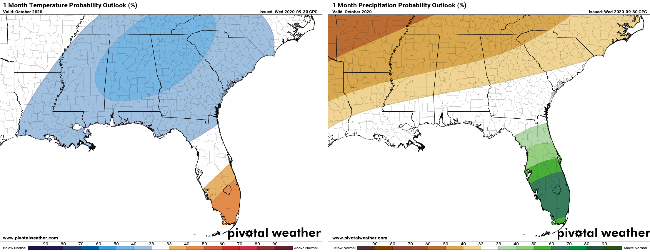
OCTOBER TEMPERATURE & RAINFALL OUTLOOKS
The latest WPC and CPC outlooks show below normal values for both temperatures and rainfall projections for the month of October. We know that October is the driest month of the year for Central Alabama so it is no surprise that projections look to be rather dry for the month. The good news is that temperatures are projected to be slightly below normal for the month. Remember, one year ago today, we set a record high of 101 degrees. I’m thankful for the nice temperatures… one bit of normalcy in this crazy 2020.
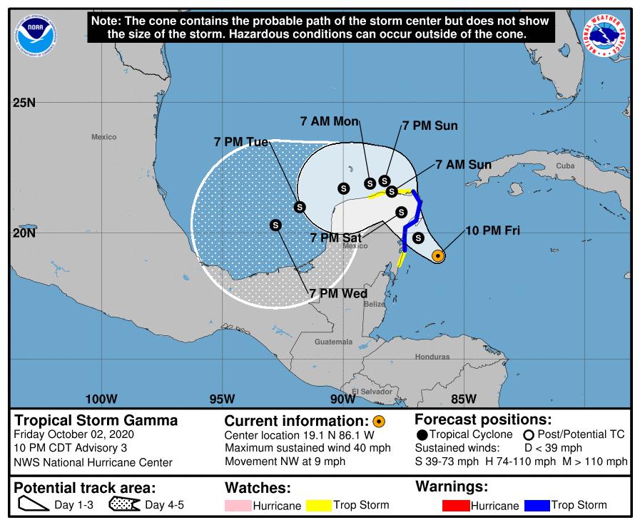
THE TROPICS (AS OF 10:00 PM FRIDAY NIGHT)
The center of Tropical Storm Gamma was located near about 110 miles south-southeast of Cozumel, Mexico. Gamma is moving toward the northwest near 9 MPH. A slower northwestward motion is expected during the next couple of days, followed by a turn to the west or west-southwest. On the forecast track, the center of Gamma should be near the northeastern Yucatan Peninsula on Saturday. Maximum sustained winds are near 40 MPH with higher gusts. Some strengthening is expected before Gamma moves inland over the northeastern Yucatan Peninsula on Saturday. After landfall, slight weakening or little change in strength is expected.
Gamma is expected to produce heavy rainfall that could result in life-threatening flash flooding over portions of the Yucatan Peninsula, far western Cuba, and well away from the center in the Mexican states of Campeche, Tabasco, and northern Chiapas. Gamma is forecast to bring tropical storm conditions to portions of the Yucatan Peninsula on Saturday, where a Tropical Storm Warning is in effect.
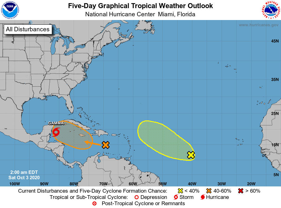
A tropical wave is producing widespread cloudiness, showers, and thunderstorms over the eastern and central Caribbean Sea, with locally heavy rainfall and gusty winds affecting portions of the ABC Islands, the Lesser Antilles, the Virgin Islands, and Puerto Rico. Environmental conditions are expected to become a little more conducive for development, and a tropical depression could form next week while the system moves westward or west-northwestward at about 15 mph across the central and western Caribbean Sea.
* Formation chance through 48 hours…low…10 percent.
* Formation chance through 5 days…medium…40 percent.
Shower activity has increased since yesterday in association with a tropical wave located about midway between the coast of Africa and the Lesser Antilles. Some slow development of this system may occur during the next several days as it moves generally westward to west-northwestward.
* Formation chance through 48 hours…low…10 percent.
* Formation chance through 5 days…low…10 percent.
ON THIS DATE IN WEATHER HISTORY
1992 – A strong low-pressure system moving northeast out of the Gulf of Mexico spawned several tornadoes in the Tampa, Florida area. One person was killed and 23 homes were destroyed as an F2 twister moved through Largo. 3 people were killed and 75 were injured in Pinellas Park as an F3 tornado ripped through. Total damage was estimated at 32 million dollars. Heavy rain Spread over northern Florida and Georgia on this day and Continued into the 4th. Jacksonville, Florida recorded 8.69 inches of rain, and Brunswick, Georgia was deluged with 10.14 inches in 24 hours. Strong winds and a long fetch pushed tides 4 to 5 feet above normal along the west coast of Florida. Major beach erosion occurred at Egmont Key and all along the coast of Hillsborough County.
BEACH FORECAST CENTER
Get the latest weather and rip current forecasts for the beaches from Dauphin Island, AL, to Panama City Beach, FL, on our Beach Forecast Center page. There, you can select the forecast of the region that you are interested in.
ADVERTISE ON THE BLOG!
We had another fantastic year in 2019 with just over 17 million page views! That brings our total for the last two years close to 37 million page views! Don’t miss out! We can customize a creative, flexible, and affordable package that will suit your organization’s needs. Contact Bill Murray at (205) 687-0782.
E-FORECAST
Get the Alabama Wx Weather Blog’s Seven-Day Forecast delivered directly to your inbox by email twice daily. It is the most detailed weather forecast available in Central Alabama. Subscribe here… It’s free!
CONNECT WITH THE BLOG ON SOCIAL MEDIA
You can find the AlabamaWx Weather Blog on the major social media networks:
Facebook
Twitter
Instagram
WEATHERBRAINS
There are several ways to watch or listen to the podcast that is all about the weather. Watch live starting at 8:00 pm CT on Monday nights at live.bigbrainsmedia.com, James Spann’s Youtube Channel, or on one of ABC 3340’s digital weather channels (17.2, 40.2, 68.3). Listen to the recorded audio podcast at WeatherBrains.com or on your favorite podcast platform (Apple Podcasts, Stitcher, Spotify, etc.), or watch the recorded video on James Spann’s Youtube channel.


