

At 4:00 pm, Gamma Continues Moving Over the Northeastern Yucatan Peninsula
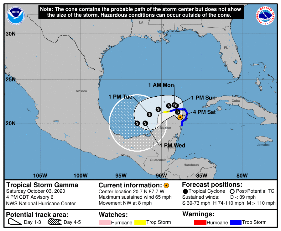
SUMMARY OF 400 PM CDT…2100 UTC…INFORMATION
LOCATION…20.7N 87.7W
ABOUT 35 MI…60 KM NNW OF TULUM MEXICO
MAXIMUM SUSTAINED WINDS…65 MPH…100 KM/H
PRESENT MOVEMENT…NW OR 325 DEGREES AT 8 MPH…13 KM/H
MINIMUM CENTRAL PRESSURE…985 MB…29.09 INCHES
WATCHES AND WARNINGS
A Tropical Storm Warning is in effect for…
* North and west of Punta Allen to Dzilam Mexico, including Cozumel
A Tropical Storm Watch is in effect for…
* West of Dzilam to Progreso Mexico
DISCUSSION AND OUTLOOK
At 400 PM CDT (2100 UTC), the center of Tropical Storm Gamma was located near latitude 20.7 North, longitude 87.7 West. Gamma is moving toward the northwest near 8 mph (13 km/h), and a turn toward the north-northwest with decreasing forward speed is expected tonight and Sunday, followed by a turn to the west or west-southwest Sunday night or Monday. On the forecast track, the center of Gamma will continue to move over the northeastern Yucatan Peninsula through tonight, move into the southern Gulf of Mexico on Sunday, and pass near or north of the northern coast of the Yucatan Peninsula Sunday night and Monday.
Maximum sustained winds have decreased to near 65 mph (100 km/h) with higher gusts. Additional weakening is forecast tonight and Sunday, followed by some re-intensification by Monday. Tropical-storm-force winds extend outward up to 80 miles (130 km) from the center.
The estimated minimum central pressure is 985 MB (29.09 inches).
HAZARDS AFFECTING LAND
RAINFALL: Gamma is expected to produce rainfall of 4 to 8 inches across portions of the Yucatan Peninsula and far western Cuba, with maximum rainfall amounts as high as 10 to 15 inches possible across northeastern Quintana Roo and northern Yucatan. This rainfall may produce life-threatening flash floods.
A separate area of significant rain is possible in the Mexican states of Campeche, Tabasco, northern Chiapas, and southeast Veracruz, with rainfall of 6 to 8 inches and isolated maximum amounts of 12 inches. This rainfall may produce life-threatening flash floods and mudslides. The storm will also result in an area of heavy rains to the south that will affect the Gulf of Fonseca region between eastern El Salvador, southern Honduras, and northwest Nicaragua with accumulation of 4 to 6 inches and isolated maximum amounts of 8 inches. Rainfall of 1 to 3 inches with maximum amounts of 5 inches is
expected over the Cayman Islands.
WIND: Tropical storm conditions should continue within the Tropical Storm Warning area on the east coast of the Yucatan Peninsula for the next several hours, and these conditions should spread across the remainder of the warning area through Sunday. Tropical Storm conditions are possible within the Tropical Storm Watch area on Monday.
Category: ALL POSTS, Severe Weather, Tropical
About the Author (Author Profile)
Scott Martin is an operational meteorologist, professional graphic artist, musician, husband, and father. Not only is Scott a member of the National Weather Association, but he is also the Central Alabama Chapter of the NWA president. Scott is also the co-founder of Racecast Weather, which provides forecasts for many racing series across the USA. He also supplies forecasts for the BassMaster Elite Series events including the BassMaster Classic.Subscribe
If you enjoyed this article, subscribe to receive more just like it.


