

Tropical Rain Returns To Alabama Late This Week
BEAUTIFUL AFTERNOON: With sunshine in full supply, temperatures are mostly in the 76-80 degree range across Alabama this afternoon, right at seasonal averages for early October. Tonight the sky will stay clear with a low in the 50s early tomorrow.
Tomorrow and Wednesday will be dry with a warming trend; the high tomorrow will be in the low 80s, followed by mid 80s Wednesday. The sky will be partly to mostly sunny both days. Then, on Thursday, clouds will increase, and rain returns to the southern counties during the morning hours. Showers will slowly move northward, reaching the northern half of the state by afternoon or Thursday evening.
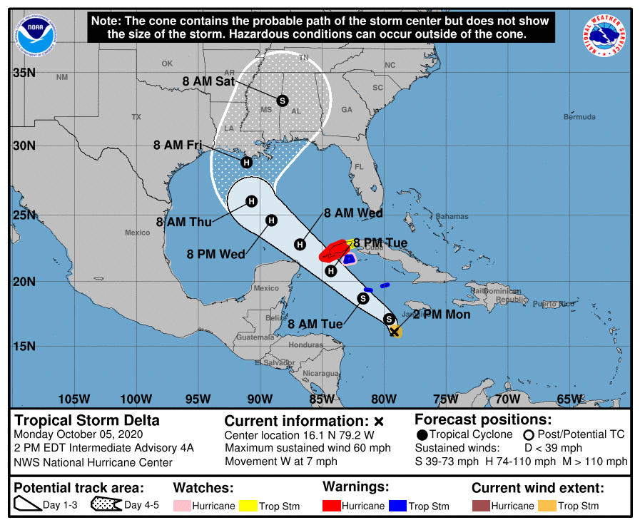
Hurricane Delta will bring tropical rain to Alabama Friday, Friday night, and into part of the day Saturday. At this point, we are projecting rain amounts of 3-6 inches for the southern 2/3 of the state (generally from I-20 south), with 2-4 inches for North Alabama. For now no major flash flooding issues are expected since the rain will be mostly light to moderate during the event, and the ground is not saturated due to the recent dry spell. Also, for now we are not expecting a big tornado threat for most of inland Alabama since the air should be stable.
Rain will end from southwest to northeast during the day Saturday. Just about impossible now to forecast the time the rain ends at any specific point since we are dealing with a tropical system that it is just getting organized in the Caribbean. Rain could linger through the evening over the Tennessee Valley region of North Alabama. Then, on Sunday, the sky becomes partly sunny with only a small risk of a stray shower. The high Saturday will be in the 70s, followed by low 80s Sunday.
NEXT WEEK: For now the weather looks mostly dry during the first half of the week, but showers are possible by Thursday or Friday (October 15-16) with an approaching cold front. See the Weather Xtreme video for maps, graphics, and more details.

TROPICS: Tropical Storm Gamma is just a swirl of low clouds with no deep convection around. It will likely dissipate within the next 36 hours, and the remnant circulation will be absorbed by the dominate system in the region, Delta.
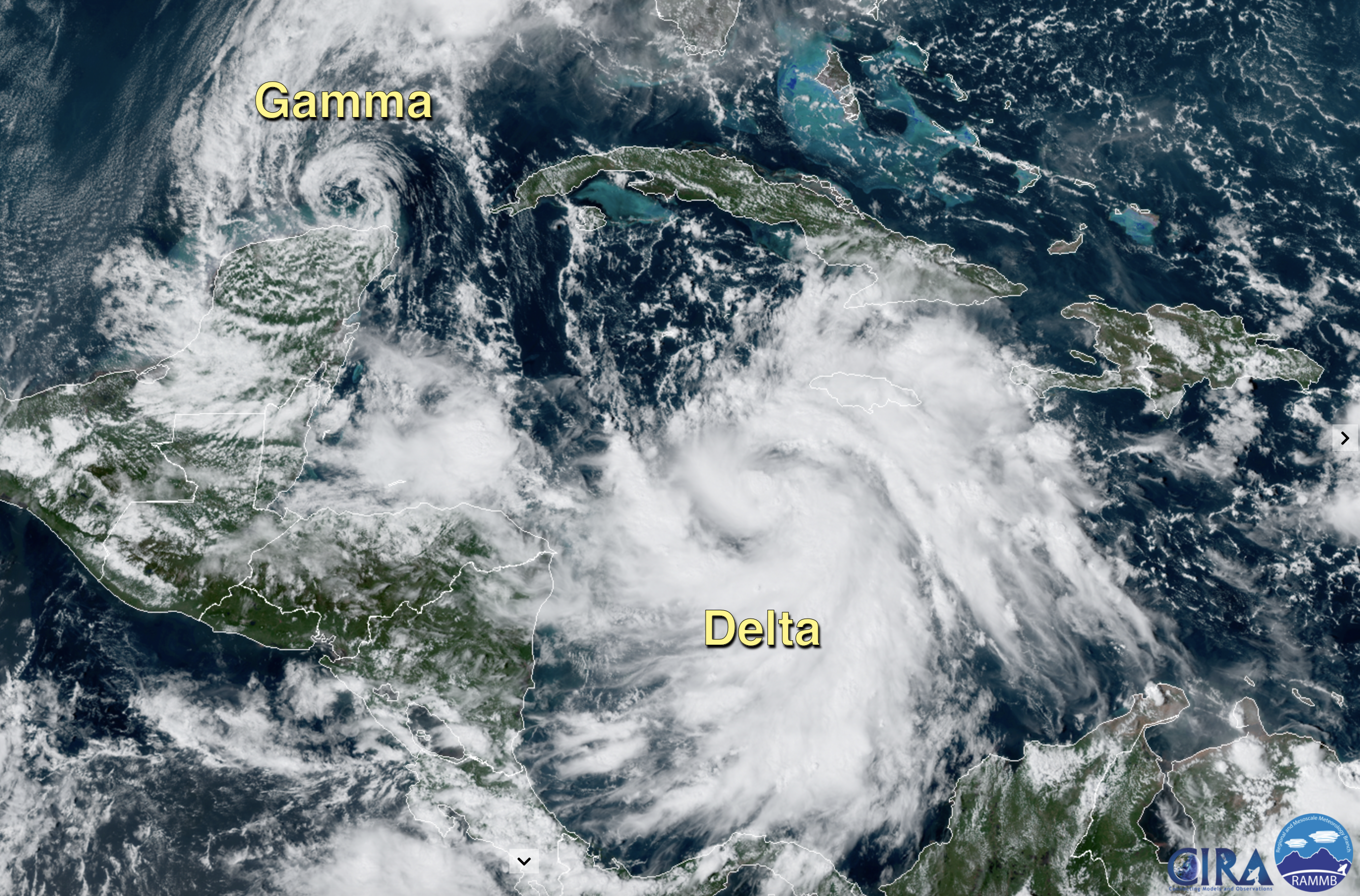
Delta is a rapidly strengthening tropical storm in the Caribbean with sustained winds of 70 mph; it most likely becomes a hurricane tonight. Sure seems like Delta will become a major hurricane (category three or higher) by tomorrow night in the southern Gulf of Mexico. Landfall is expected Friday morning on the Louisiana coast between Grand Isle and Morgan City.
Increasing southwesterly shear and the cooler shelf waters over the northern Gulf are likely to induce some weakening before landfall.
COASTAL IMPACT: A hurricane watch will be required for parts of the Central Gulf Coast by tomorrow afternoon or evening. At this point it looks like the greatest wind and storm surge impact will come across Southeast Louisiana and Mississippi, but some storm surge flooding is possible along the Alabama coast as well. It all depends on the position, size, and strength of the hurricane.
Dangerous rip currents are likely along the Alabama and Northwest Florida coasts tomorrow through Friday night; expect double red flags.
Most of the rain on the coast will come Thursday, Friday, and Friday night. The weather will improve over the weekend as the system lifts northeast, away from the region. Rain amounts on the coast of 3-6″ are likely, with isolated amounts to 8″. A few isolated waterspouts, or brief tornadoes, are possible Thursday night and Friday.
We will be much more specific about the impact on the coast within the day or two as the system evolves.
It is important to watch for updates; when it comes to tropical systems, if you are working with old information, you are working with bad information. Always expect changes.
ON THIS DATE IN 1972: Tropical Storm Joanne, earlier a hurricane, moved across the Baja California peninsula and came ashore in western Mexico south of Ajo. The storm brought heavy rain and flooding to much of Arizona. This storm is the first documented tropical storm to reach Arizona, with its cyclonic circulation intact. Over 5 inches of rain was reported on the Mogollon rim southeast of Flagstaff. Additional rainfall amounts included 4.44 at Flagstaff, 3.80 at Prescott, 2.21 at Yuma, 1.95 at Phoenix, 1.63 at Nogales, and 1.63 at Tucson.
BEACH FORECAST: Click here to see the AlabamaWx Beach Forecast Center page.
WEATHER BRAINS: Don’t forget you can listen to our weekly 90 minute show anytime on your favorite podcast app. This is the show all about weather featuring many familiar voices, including our meteorologists here at ABC 33/40.
CONNECT: You can find me on all of the major social networks…
Facebook
Twitter
Instagram
Pinterest
Snapchat: spannwx
Look for the next Weather Xtreme video here by 7:00 a.m. tomorrow…
Category: Alabama's Weather, ALL POSTS, Weather Xtreme Videos
About the Author (Author Profile)
James Spann is one of the most recognized and trusted television meteorologists in the industry. He holds the AMS CCM designation and television seals from the AMS and NWA. He is a past winner of the Broadcast Meteorologist of the Year from both professional organizations.Subscribe
If you enjoyed this article, subscribe to receive more just like it.


