

Delta Brings Rain To Alabama By Friday/Saturday
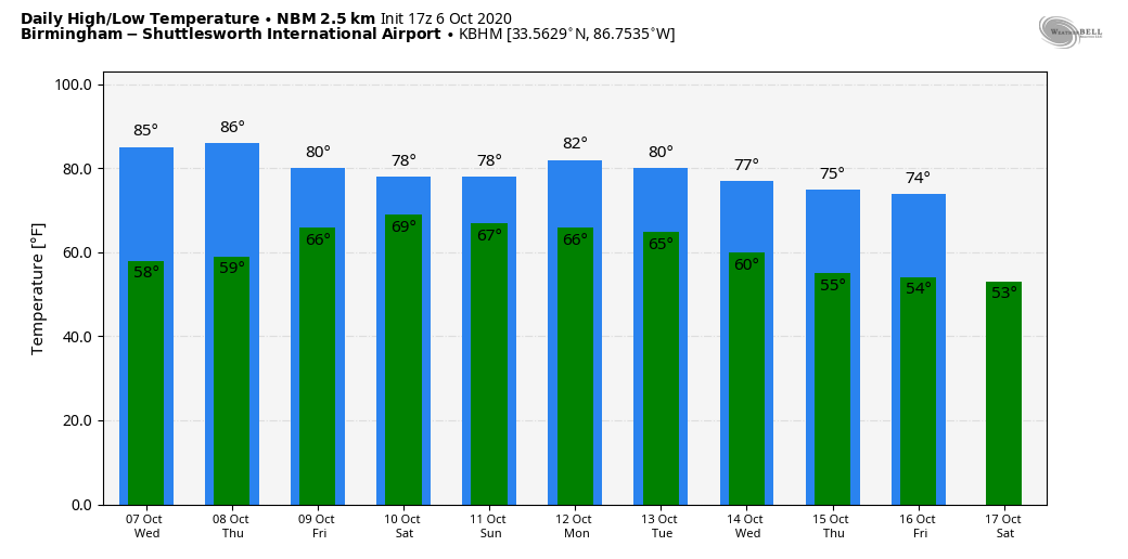
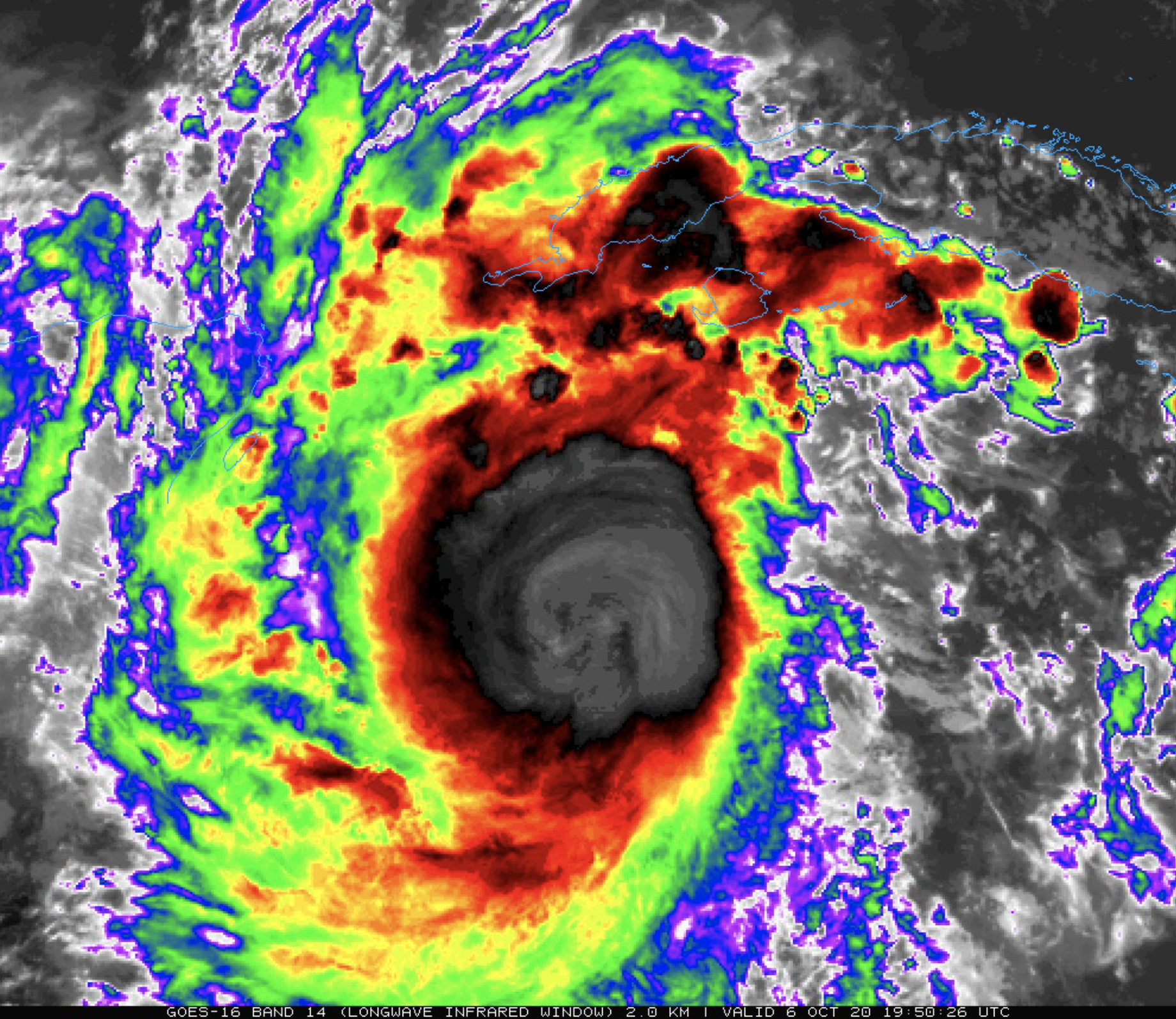
RAPIDLY DEVELOPING DELTA: Eyes are on extremely dangerous category four Hurricane Delta in the Caribbean, but today the weather remains quiet across Alabama. The sky is sunny over the northern half of the state; high cirrus clouds are over South Alabama. Temperatures, as expected, are warmer with low 80s in most locations. Tomorrow will be another warm, dry day with highs in the mid 80s along with a partly to mostly sunny sky.
Showers are possible over South Alabama Thursday, but the northern half of the state will likely remain warm and dry with a mix of sun and clouds. Then, on Friday, we will mention some risk of showers statewide, but the day won’t be a “wash-out”. Showers become more widespread Friday night as Hurricane Delta moves onto the Louisiana coast.
SATURDAY SOAKER: Saturday will be breezy and very wet across Alabama as we will be on the wet, east side of the circulation of Delta. Rain is likely most of the day, and we will also have some potential for a few brief, isolated tornadoes as models continue to trend toward an atmosphere with greater instability. Rain continues Saturday night, and will end Sunday morning as the remnant circulation of Delta lifts away from the region. Rain amounts over much of Alabama will be in the 1-3 inch range, with potential for heavier totals over the western counties. For now flash flooding is not expected since the rain will be spread out over a long period, and the ground is not saturated thanks to the recent dry spell.
Winds on Saturday over West Alabama could gust to 40 mph in spots; otherwise winds will be generally in the 15-25 mph range during the day across inland parts of Alabama.
The sky becomes partly sunny Sunday afternoon as drier air creeps into the state. Highs over the weekend will be in the 75-80 degree range.
NEXT WEEK: Monday looks warm and dry, then a cold front will bring a chance of showers, and possibly a few thunderstorms Tuesday. Cooler and drier air rolls in for the latter half of the week… See the Weather Xtreme video for maps, graphics, and more details.
THE LATEST ON DELTA: Delta is now a category four hurricane with sustained winds of 145 mph. It will move very close to Cancun, and the northern tip of the Yucatan Peninsula early tomorrow with potential for severe damage. From there, it moves into the southern Gulf of Mexico tomorrow afternoon, and it is not out of the question for the system to briefly reach category five strength.
Increasing southwesterly shear and cooler shelf waters near the Gulf coast are expected to cause some reduction in wind speed, but Delta is still expected to be a dangerous hurricane when it nears the Louisiana coast.
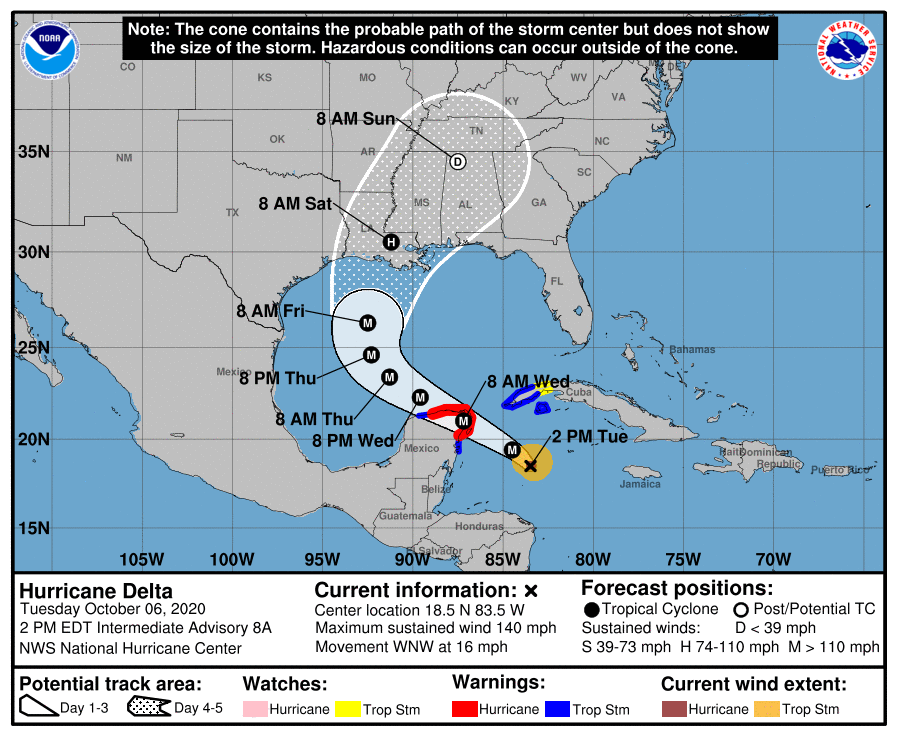
The remnant circulation is forecast to move into Northwest Alabama by early Sunday morning.
COASTAL IMPACT: Here are some notes for coastal Alabama and Northwest Florida…
*While the primary storm surge and wind damage threat will be west of Alabama, across Southeast Louisiana and the Mississippi coast, some surge flooding is likely along the Alabama Gulf Coast Friday into Saturday morning. It is a little too early to forecast surge amounts.
*Sustained winds of 20-40 mph look likely for Mobile and Baldwin counties Friday night, with gusts to 45 mph. Winds across the Florida Panhandle (Pensacola to Panama City Beach) will be in the 15-25 mph range.
*A few brief waterspouts or tornadoes are possible Friday and Friday night anywhere from the Mississippi coast to Apalachicola.
*Dangerous rip currents are likely on the Gulf Coast through Saturday.
*Rain amounts for Mobile and Baldwin counties should be close to 4 inches; amounts for the Florida Panhandle are forecast to be in the 2-3 inch range.
*While rain is likely along the Alabama and NW Florida coasts Thursday, Friday, and into early Saturday, the weather will improve on the Gulf Coast Saturday afternoon as Delta moves inland. Then, routine weather is expected Sunday through much of next week with a good supply of sunshine each day.
REMEMBER: When you are dealing with a tropical system, forecast changes are likely. Be sure and see the latest updates in coming days; if you are working with old information, you are working with bad information.
FOOTBALL WEATHER: Many of the high school games have been moved to Thursday night; the weather will be dry over the northern half of the state with temperatures falling through the 70s. Showers are likely Friday night with temperatures in the 70s.
Saturday, Auburn hosts Arkansas (3:00p CT kickoff) at Jordan-Hare Stadium. Rain is likely during the game, with winds of 15-25 mph. Temperatures will be in the 75-80 degree range, and there could be a low end risk of brief tornado over East Alabama Saturday afternoon.
Alabama will take on Ole Miss on the road at Oxford (5:00p CT kickoff). The weather looks windy and wet due to the remnant circulation of Delta; winds could gust as high as 30/35 mph during the game. Rain is likely; temperatures will be in the 70s. The amount of rain during the game depends on the position of Delta’s circulation.
Jacksonville State will host Mercer (2p CT kickoff); rain is likely with temperatures in the upper 70s. Like Auburn, a low end risk of a brief tornado could develop over Northeast Alabama.
ON THIS DATE IN 2016: The center of Category 4 Hurricane Matthew passed within 100 miles of Miami, Florida. The hurricane would later make landfall at Cape Romain National Wildlife Refuge, near McClellanville, South Carolina, with winds of 85 mph and a central pressure of 963 mb, which made it the strongest to strike the United States in terms of pressure since Irene in 2011, and the first hurricane to make landfall north of Florida in October since Hurricane Hazel in 1954.
BEACH FORECAST: Click here to see the AlabamaWx Beach Forecast Center page.
WEATHER BRAINS: Don’t forget you can listen to our weekly 90 minute show anytime on your favorite podcast app. This is the show all about weather featuring many familiar voices, including our meteorologists here at ABC 33/40.
CONNECT: You can find me on all of the major social networks…
Facebook
Twitter
Instagram
Pinterest
Snapchat: spannwx
Look for the next Weather Xtreme video here by 7:00 a.m. tomorrow…
Category: Alabama's Weather, ALL POSTS, Weather Xtreme Videos
About the Author (Author Profile)
James Spann is one of the most recognized and trusted television meteorologists in the industry. He holds the AMS CCM designation and television seals from the AMS and NWA. He is a past winner of the Broadcast Meteorologist of the Year from both professional organizations.Subscribe
If you enjoyed this article, subscribe to receive more just like it.


