

Showers Tomorrow; Wet Weekend Ahead
THIS AFTERNOON: Mid to high level clouds are advancing into Alabama this afternoon; a showers are over Southwest Alabama but most of the state is dry with temperatures in the 80-85 degree range. Clouds will continue to thicken tonight.
Tomorrow will be a cloudy day with occasional showers likely, becoming more numerous tomorrow night. The high tomorrow will be in the mid to upper 70s.
WET WEEKEND: Alabama will be on the wet, east side of the circulation of Hurricane Delta as it moves inland over Louisiana and weakens; Saturday will be breezy with rain much of the day, but not necessarily all day. Winds will average 15-25 mph, with gusts possible to 30 mph near the Mississippi border. If the air can sufficiently destabilize, a few brief, isolated tornadoes will be possibly, mostly during the afternoon and evening hours. SPC has most of North and Central Alabama in a “marginal risk” (level 1/5)…
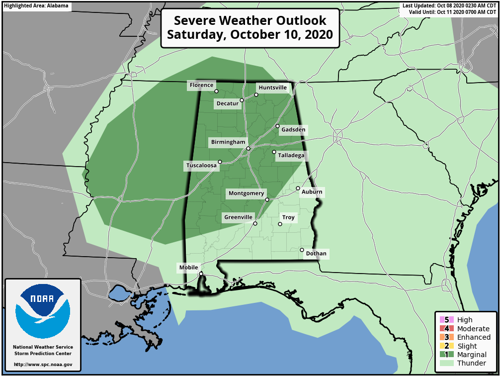
Keep in mind tornadoes associated with tropical systems tend to be short lived, and low topped. Meaning, they can literally be “under the radar” and very hard to detect. Just be weather aware Saturday, and be sure you can hear severe weather warnings if they are needed.
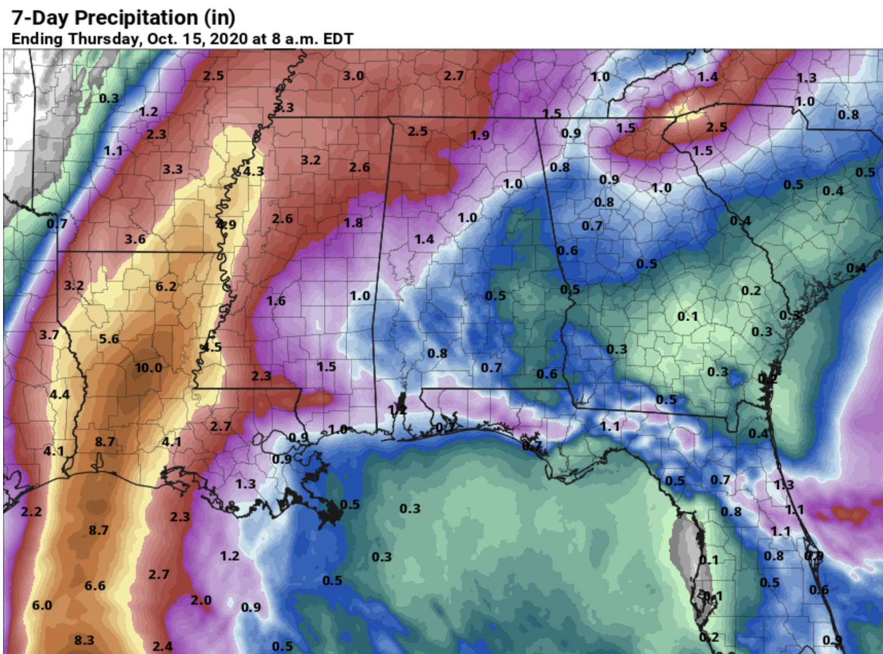
Models are trending wetter on Sunday; looks like periods of rain could continue through a decent part of the day over the northern half of the state. Rain totals through Sunday night will be around 2.5 inches for the northwest corner of the state, and around 1 to 1.5 inches for places like Birmingham, Tuscaloosa, Gadsden, and Mobile. Lighter amounts will be found from Anniston south on the eastern side of the state, generally under one inch. Flooding issues are not expected.
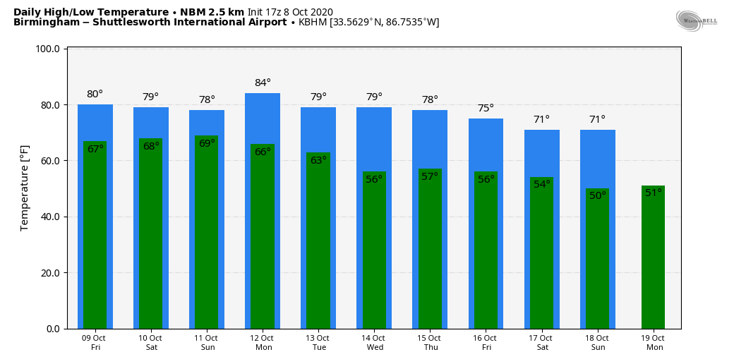
NEXT WEEK: The week looks generally dry. Highs will be in the low to mid 80s early in the week; cooler air arrives by Thursday and Friday. See the Weather Xtreme video for maps, graphics, and more details.
DELTA: Hurricane Delta is packing sustained winds of 105 mph this afternoon, and is about 350 miles south of Cameron, Louisiana…. moving northwest at 13 mph.
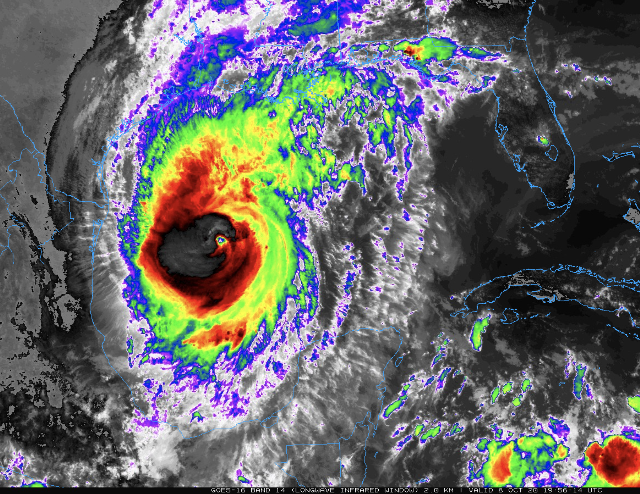
The hurricane is expected to reach category three strength late tonight or tomorrow, before weakening to a category two at the time of landfall tomorrow evening on the Southwest Louisiana coast.
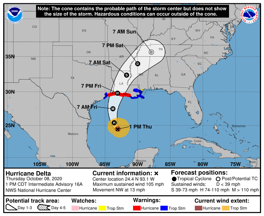
The primary wind and storm surge issues will be west of Alabama; storm surge values on the Alabama coast and Mobile Bay are expected to be 1-3 feet. Rain amounts of 1-2 inches are expected on the Alabama and Northwest Florida coast through tomorrow night; no flooding problems are anticipated. However, a few isolated, brief waterspouts or tornadoes are possible tomorrow and tomorrow night.
Also, dangerous rip currents are likely through Saturday… expect double red flags. The surf will begin to settle down Sunday. The weather will improve on the Gulf Coast Saturday as the sky becomes partly sunny, and Sunday should feature a good supply of sunshine. Just a few isolated showers from Gulf Shores to Panama City Beach over the weekend.
FOOTBALL WEATHER: Many of the high school games have been moved to tonight; the weather will be dry over the northern half of the state with temperatures falling through the 70s. Showers are likely tomorrow night with temperatures in the 70s.
Saturday, Auburn hosts Arkansas (3:00p CT kickoff) at Jordan-Hare Stadium. Periods of rain are likely during the game, with a south wind of 10-20 mph. Temperatures will be in the mid to upper 70s.
Alabama will take on Ole Miss on the road at Oxford (5:00p CT kickoff). It will be windy and wet due to the remnant circulation of Delta; rain is likely, especially during the first half. Winds will be in the 15-25 mph range, with possible gusts to 30 mph during the first quarter.
Jacksonville State will host Mercer (2p CT kickoff); occasional rain is likely with temperatures in the mid to upper 70s.
ON THIS DATE IN 1946: A minimal Category 1 hurricane made landfall over Bradenton, Florida, before tracking north-northeast across Tampa Bay. The storm was the last hurricane to make direct landfall in the Tampa Bay area.
BEACH FORECAST: Click here to see the AlabamaWx Beach Forecast Center page.
WEATHER BRAINS: Don’t forget you can listen to our weekly 90 minute show anytime on your favorite podcast app. This is the show all about weather featuring many familiar voices, including our meteorologists here at ABC 33/40.
CONNECT: You can find me on all of the major social networks…
Facebook
Twitter
Instagram
Pinterest
Snapchat: spannwx
Look for the next Weather Xtreme video here by 7:00 a.m. tomorrow…
Category: Alabama's Weather, ALL POSTS, Weather Xtreme Videos
About the Author (Author Profile)
James Spann is one of the most recognized and trusted television meteorologists in the industry. He holds the AMS CCM designation and television seals from the AMS and NWA. He is a past winner of the Broadcast Meteorologist of the Year from both professional organizations.Subscribe
If you enjoyed this article, subscribe to receive more just like it.


