

Tornado Watch Possible for Parts of Central Alabama This Afternoon
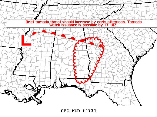
SUMMARY…The threat for brief tornadoes associated with Tropical Depression Delta is expected to increase by early afternoon. Tornado watch issuance is possible by 17-18Z (12 pm-1 pm).
DISCUSSION…At 16Z (11 am), T.D. Delta is centered over northwest MS, with a substantial midlevel dry slot (noted on WV imagery) wrapping into the southern and eastern portions of the cyclone. The primary convective band has pushed into central AL and the western FL Panhandle. Little to no lightning has been observed with this band throughout the morning, and the generally linear convective mode has thus far limited the threat for brief tornadoes. However, modest heating near and south of a northward-moving warm front should result in gradual destabilization across eastern AL/western GA into the FL Panhandle over the next several hours. As a result, ongoing convection may gradually intensify as it spreads eastward, with additional more cellular development possible ahead of the primary band by afternoon.
While wind fields will gradually weaken as T.D. Delta continues to decay this afternoon, effective shear of 35-45 kt should support some organized structures with any more robust convection this afternoon. Low-level shear/SRH (storm-relative helicity) will support a brief tornado threat, especially with any semi-discrete convection that can be sustained in closer proximity to the warm front. Some damaging wind gusts will also be possible with any of the linear elements within the broader convective band. Tornado watch issuance is possible by 17-18Z (12 pm-1 pm).
Category: Alabama's Weather, ALL POSTS, Severe Weather, Tropical
About the Author (Author Profile)
Scott Martin is an operational meteorologist, professional graphic artist, musician, husband, and father. Not only is Scott a member of the National Weather Association, but he is also the Central Alabama Chapter of the NWA president. Scott is also the co-founder of Racecast Weather, which provides forecasts for many racing series across the USA. He also supplies forecasts for the BassMaster Elite Series events including the BassMaster Classic.Subscribe
If you enjoyed this article, subscribe to receive more just like it.


