

Zeta Continues to Strengthen, Possibly into a Hurricane by Late Monday
SUMMARY OF 1100 PM EDT…0300 UTC…INFORMATION (FROM THE NHC)
————————————————————–
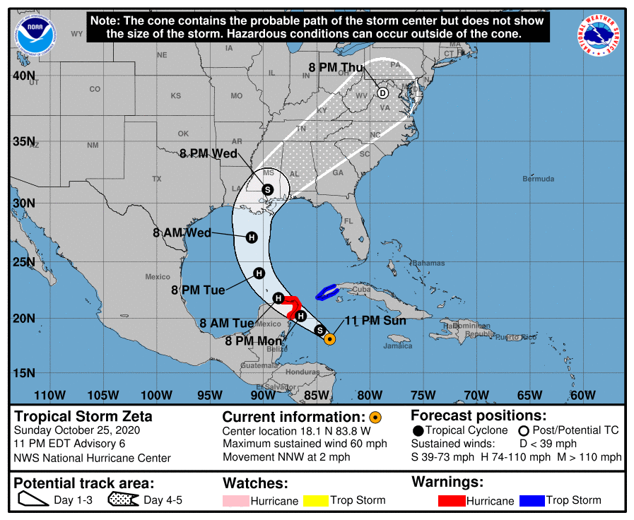
LOCATION…18.1N 83.8W
ABOUT 260 MI…420 KM SE OF COZUMEL MEXICO
ABOUT 270 MI…440 KM SSE OF THE WESTERN TIP OF CUBA
MAXIMUM SUSTAINED WINDS…60 MPH…95 KM/H
PRESENT MOVEMENT…NNW OR 330 DEGREES AT 2 MPH…4 KM/H
MINIMUM CENTRAL PRESSURE…997 MB…29.44 INCHES
WATCHES AND WARNINGS
——————–
CHANGES WITH THIS ADVISORY:
None.
SUMMARY OF WATCHES AND WARNINGS IN EFFECT:
A Hurricane Warning is in effect for…
* Tulum to Rio Lagartos Mexico
* Cozumel
A Tropical Storm Warning is in effect for…
* Pinar del Rio Cuba
A Hurricane Warning means that hurricane conditions are expected
somewhere within the warning area. A warning is typically issued
36 hours before the anticipated first occurrence of
tropical-storm-force winds, conditions that make outside
preparations difficult or dangerous. Preparations to protect life
and property should be rushed to completion.
A Tropical Storm Warning means that tropical storm conditions are
expected somewhere within the warning area within 36 hours.
For storm information specific to your area, please monitor
products issued by your national meteorological service.
DISCUSSION AND OUTLOOK
———————-
At 1100 PM EDT (0300 UTC), the center of Tropical Storm Zeta was
located near latitude 18.1 North, longitude 83.8 West. Zeta is
drifting toward the north-northwest near 2 mph (4 km/h) but a faster
northwestward motion is expected over the next couple of days,
followed by a turn to the north. On the forecast track, the center
of Zeta will move near or over the northern Yucatan Peninsula or the
Yucatan Channel late Monday, move over the southern Gulf of Mexico
on Tuesday, and approach the northern Gulf Coast on Wednesday.
Maximum sustained winds are near 60 mph (95 km/h) with higher gusts.
Strengthening is forecast, and Zeta is expected to become a
hurricane before it moves near or over the Yucatan Peninsula late
Monday.
Tropical-storm-force winds extend outward up to 115 miles (185 km)
from the center.
The estimated minimum central pressure is 997 MB (29.44 inches).
KEY MESSAGES
———————-
1. Hurricane conditions and storm surge are expected in portions of
the northern Yucatan Peninsula of Mexico Monday night and early
Tuesday. Tropical storm conditions could occur over extreme western
Cuba on Monday.
2. Through Wednesday, heavy rainfall is expected from Zeta across
portions of central and western Cuba, the Cayman Islands, Jamaica,
the northeast Yucatan peninsula of Mexico, southern Florida and the
Keys. This rainfall could lead to flash flooding in urban areas.
3. Zeta is forecast to be at or near hurricane strength when
it approaches the northern Gulf Coast on Wednesday, and there is an
increasing risk of storm surge, rainfall, and wind impacts from
Louisiana to the Florida Panhandle. Residents in these areas should
monitor the progress of Zeta and updates to the forecast.
Category: ALL POSTS, Severe Weather, Tropical
About the Author (Author Profile)
Scott Martin is an operational meteorologist, professional graphic artist, musician, husband, and father. Not only is Scott a member of the National Weather Association, but he is also the Central Alabama Chapter of the NWA president. Scott is also the co-founder of Racecast Weather, which provides forecasts for many racing series across the USA. He also supplies forecasts for the BassMaster Elite Series events including the BassMaster Classic.Subscribe
If you enjoyed this article, subscribe to receive more just like it.


