

Tropical Storm Watch for Parts of Central Alabama Until Further Notice
A Tropical Storm Watch means tropical-storm-force winds are possible
somewhere within this area within the next 48 hours
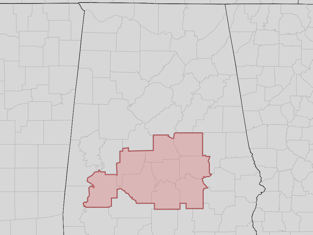
* LOCATIONS AFFECTED
– Autauga, Chilton, Coosa, Dallas, Elmore, Lowndes, Marengo,
Montgomery, Perry counties in Central Alabama until further
notice.
* WIND
– LATEST LOCAL FORECAST: Equivalent Tropical Storm force wind
– Peak Wind Forecast: 30-40 mph with gusts to 50 mph
– Window for Tropical Storm force winds: Wednesday evening
until early Thursday morning
– THREAT TO LIFE AND PROPERTY THAT INCLUDES TYPICAL FORECAST
UNCERTAINTY IN TRACK, SIZE, AND INTENSITY: Potential for wind 58
to 73 mph
– PLAN: Plan for dangerous wind of equivalent strong tropical
storm force.
– PREPARE: Efforts to protect life and property should now be
underway. Prepare for significant wind damage.
– ACT: Act now to complete preparations before the wind
becomes hazardous.
– POTENTIAL IMPACTS: Significant
– Some damage to roofing and siding materials, along with
damage to porches, awnings, carports, and sheds. A few
buildings experiencing window, door, and garage door
failures. Mobile homes damaged, especially if unanchored.
Unsecured lightweight objects become dangerous projectiles.
– Several large trees snapped or uprooted, but with greater
numbers in places where trees are shallow rooted. Several
fences and roadway signs blown over.
– Some roads impassable from large debris, and more within
urban or heavily wooded places. A few bridges, causeways,
and access routes impassable.
– Scattered power and communications outages, but more
prevalent in areas with above ground lines.
* FLOODING RAIN
– LATEST LOCAL FORECAST:
– Peak Rainfall Amounts: 3-6 inches, with locally higher
amounts
– THREAT TO LIFE AND PROPERTY THAT INCLUDES TYPICAL FORECAST
UNCERTAINTY IN TRACK, SIZE AND INTENSITY: Potential for
moderate flooding rain
– PLAN: Emergency plans should include the potential for
moderate flooding from heavy rain. Evacuations and rescues
are possible.
– PREPARE: Consider protective actions if you are in an area
vulnerable to flooding.
– ACT: Heed any flood watches and warnings. Failure to take
action may result in serious injury or loss of life.
– POTENTIAL IMPACTS: Significant
– Moderate rainfall flooding may prompt several evacuations
and rescues.
– Rivers and tributaries may quickly become swollen with
swifter currents and overspill their banks in a few places,
especially in usually vulnerable spots. Small streams,
creeks, canals, arroyos, and ditches overflow.
– Flood waters can enter some structures or weaken
foundations. Several places may experience expanded areas
of rapid inundation at underpasses, low-lying spots, and
poor drainage areas. Some streets and parking lots take on
moving water as storm drains and retention ponds overflow.
Driving conditions become hazardous. Some road and bridge
closures.
* TORNADO
– LATEST LOCAL FORECAST:
– Situation is unfavorable for tornadoes
– THREAT TO LIFE AND PROPERTY THAT INCLUDES TYPICAL FORECAST
UNCERTAINTY IN TRACK, SIZE AND INTENSITY: Tornadoes not expected
– PLAN: Tornadoes are not expected. Showers and thunderstorms
with gusty winds may still occur.
– PREPARE: Little to no preparations needed to protect
against tornadoes at this time. Keep informed of the latest
tornado situation.
– ACT: Listen for changes in the forecast.
– POTENTIAL IMPACTS: Little to None
– Little to no potential impacts from tornadoes.
Category: Alabama's Weather, ALL POSTS, Severe Weather, Tropical
About the Author (Author Profile)
Scott Martin is an operational meteorologist, professional graphic artist, musician, husband, and father. Not only is Scott a member of the National Weather Association, but he is also the Central Alabama Chapter of the NWA president. Scott is also the co-founder of Racecast Weather, which provides forecasts for many racing series across the USA. He also supplies forecasts for the BassMaster Elite Series events including the BassMaster Classic.Subscribe
If you enjoyed this article, subscribe to receive more just like it.


