

Tropical Storm Watch Expanded to Include Lee, Pike, Macon, and Bullock Counties
Hurricane Zeta Local Statement Advisory Number 15
National Weather Service Birmingham AL AL282020
417 AM CDT Wed Oct 28 2020
This product covers Central Alabama
**Tropical Storm Watch Expanded Across Southeast Central Alabama**
NEW INFORMATION
—————
* CHANGES TO WATCHES AND WARNINGS:
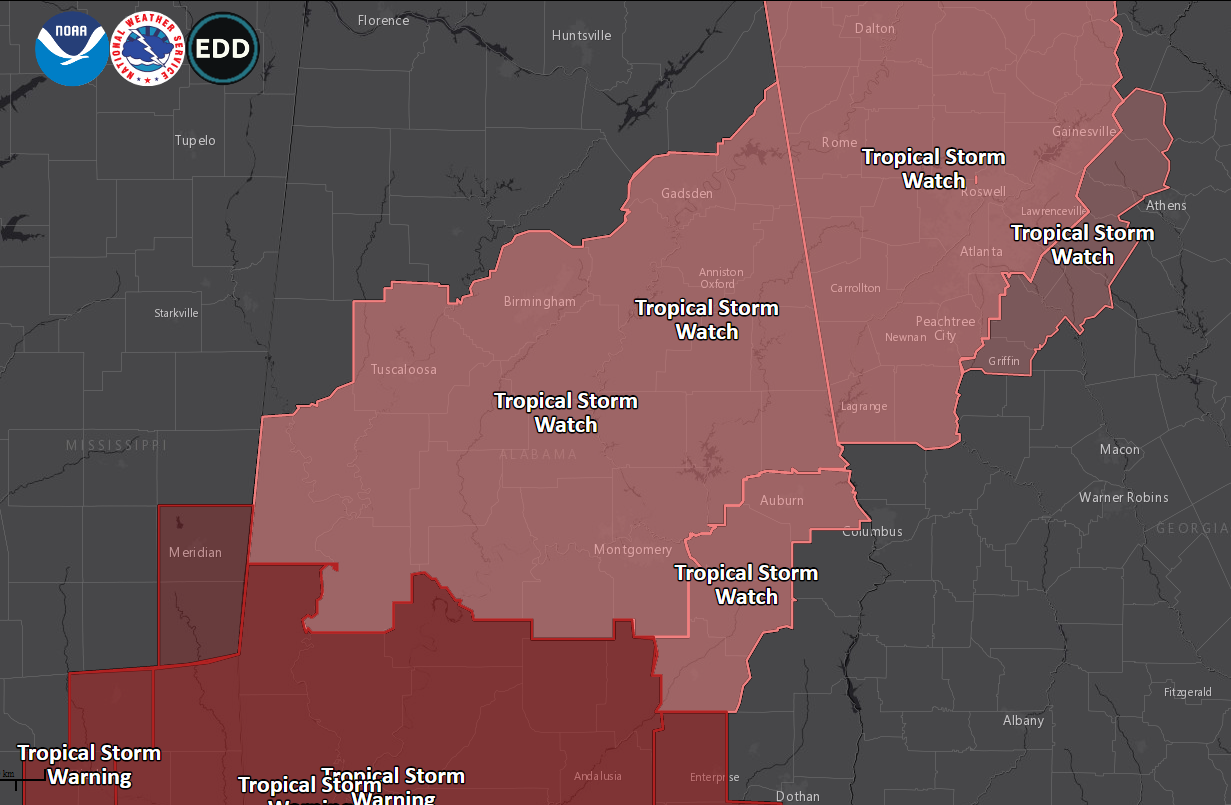
– A Tropical Storm Watch has been issued for Bullock, Lee, Macon,
and Pike
* CURRENT WATCHES AND WARNINGS:
– A Tropical Storm Watch is in effect for Autauga, Bibb, Bullock,
Calhoun, Chambers, Cherokee, Chilton, Clay, Cleburne, Coosa,
Dallas, Elmore, Etowah, Greene, Hale, Jefferson, Lee, Lowndes,
Macon, Marengo, Montgomery, Perry, Pike, Randolph, Shelby, St.
Clair, Sumter, Talladega, Tallapoosa, and Tuscaloosa
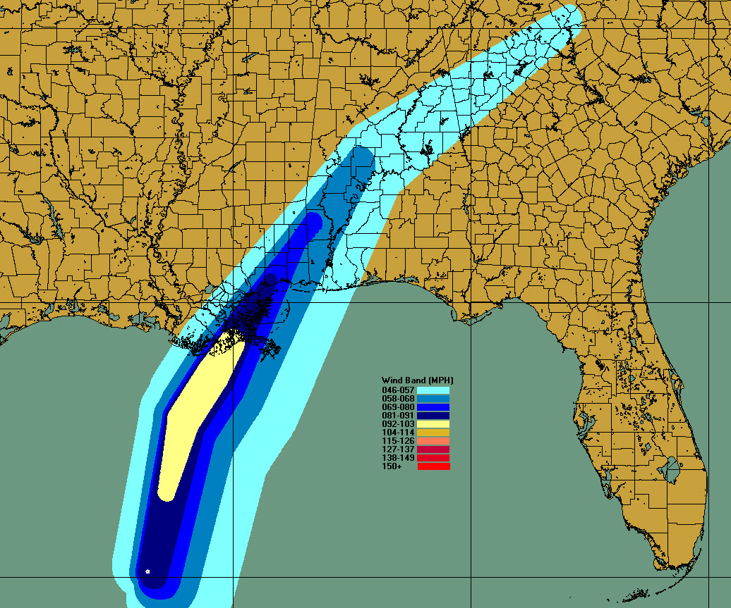
* STORM INFORMATION:
– About 650 miles south-southwest of Birmingham AL or about 600
miles southwest of Montgomery AL
– 25.1N 91.8W
– Storm Intensity 85 mph
– Movement North-northwest or 345 degrees at 17 mph
SITUATION OVERVIEW
——————
Zeta has re-strengthened into a hurricane over the Gulf this morning. Zeta
is expected to make landfall along the northern Gulf Coast later today
and move quickly across Central Alabama tonight. A swath of 40 to 60
mph wind gusts is expected to occur along and to the right of Zeta`s
track, roughly south of Interstate 59. Additional rainfall amounts of
2 to 3 inches are expected with locally higher amounts, which may
cause localized flash flooding. There is also a low threat of a brief
tornado tonight across southern and southeastern portions of Central
Alabama.
POTENTIAL IMPACTS
—————–
* WIND:
Prepare for dangerous wind having possible significant impacts across
Central Alabama. Potential impacts in this area include:
– Some damage to roofing and siding materials, along with damage
to porches, awnings, carports, and sheds. A few buildings
experiencing window, door, and garage door failures. Mobile
homes damaged, especially if unanchored. Unsecured lightweight
objects become dangerous projectiles.
– Several large trees snapped or uprooted, but with greater
numbers in places where trees are shallow rooted. Several
fences and roadway signs blown over.
– Some roads impassable from large debris, and more within urban
or heavily wooded places. A few bridges, causeways, and access
routes impassable.
– Scattered power and communications outages, but more prevalent
in areas with above ground lines.
* FLOODING RAIN:
Prepare for dangerous rainfall flooding having possible significant
impacts across Central Alabama. Potential impacts include:
– Moderate rainfall flooding may prompt several evacuations and
rescues.
– Rivers and tributaries may quickly become swollen with swifter
currents and overspill their banks in a few places, especially
in usually vulnerable spots. Small streams, creeks, canals,
arroyos, and ditches overflow.
– Flood waters can enter some structures or weaken foundations.
Several places may experience expanded areas of rapid
inundation at underpasses, low-lying spots, and poor drainage
areas. Some streets and parking lots take on moving water as
storm drains and retention ponds overflow. Driving conditions
become hazardous. Some road and bridge closures.
* TORNADOES:
Prepare for a tornado event having possible limited impacts across
southern portions of Central Alabama. Potential impacts include:
– The occurrence of isolated tornadoes can hinder the execution
of emergency plans during tropical events.
– A few places may experience tornado damage, along with power
and communications disruptions.
– Locations could realize roofs peeled off buildings, chimneys
toppled, mobile homes pushed off foundations or overturned,
large tree tops and branches snapped off, shallow-rooted trees
knocked over, moving vehicles blown off roads, and boats pulled
from moorings.
Elsewhere across Central Alabama, little to no impact is anticipated.
PRECAUTIONARY/PREPAREDNESS ACTIONS
———————————-
* OTHER PREPAREDNESS INFORMATION:
Now is the time to check your emergency plan and emergency supplies
kit and take necessary actions to protect your family and secure your
home or business.
When making safety and preparedness decisions, do not focus on the
exact forecast track since hazards such as flooding rain, damaging
wind gusts, storm surge, and tornadoes extend well away from the
center of the storm.
If in a place that is vulnerable to high wind, such as near large
trees, a manufactured home, upper floors of a high-rise building, or
on a boat, plan to move to safe shelter.
If you live in a place particularly vulnerable to flooding, such as
in a low-lying or poor drainage area, in a valley, or near an already
swollen river, plan to move to safe shelter on higher ground.
Closely monitor weather.gov, NOAA Weather Radio and local news outlets
for official storm information. Listen for possible changes to the
forecast.
There is a threat from tornadoes with this storm. Have multiple ways
to receive Tornado Warnings. Be ready to shelter quickly.
* ADDITIONAL SOURCES OF INFORMATION:
– For information on appropriate preparations see ready.gov
– For information on creating an emergency plan see getagameplan.org
– For additional disaster preparedness information see redcross.org
NEXT UPDATE
———–
The next local statement will be issued by the National Weather
Service in Birmingham AL around 10 AM CDT, or sooner if conditions
warrant.
$$
Category: Alabama's Weather, ALL POSTS, Tropical
About the Author (Author Profile)
Bill Murray is the President of The Weather Factory. He is the site's official weather historian and a weekend forecaster. He also anchors the site's severe weather coverage. Bill Murray is the proud holder of National Weather Association Digital Seal #0001 @wxhistorianSubscribe
If you enjoyed this article, subscribe to receive more just like it.


