

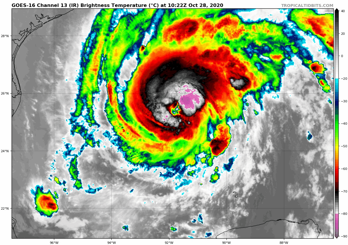
Zeta Stronger: Pressure Down to 978 millibars, Winds up to 90 mph
Air Force and NOA Hurricane Hunters continue to find that Hurricane Zeta is intensifying this morning.
A recent penetration revealed a central pressure of 979 millibars and max flight-level winds of 89 knots, which translates into a surface wind of a little over 90 mph. The eye is shrinking, now 16 nautical miles in diameter.
The strengthening trend may be leveling off though, as evidenced by a slight decrease in the intense convection around the center, which is not quite as distinct as it was earlier. The system is about to be moving over cooler waters, which are borderline for intensification. And increasing wind shear should act as a curb on intensification as well.
Here is the complete text of the 7 a.m. advisory:
BULLETIN
Hurricane Zeta Intermediate Advisory Number 15A
NWS National Hurricane Center Miami FL AL282020
700 AM CDT Wed Oct 28 2020
…ZETA CONTINUING TO STRENGTHEN…
…LIFE-THREATENING STORM SURGE AND STRONG WINDS EXPECTED ALONG
PORTIONS OF THE NORTHERN GULF COAST BEGINNING AROUND MIDDAY…
SUMMARY OF 700 AM CDT…1200 UTC…INFORMATION
———————————————-
LOCATION…26.0N 91.7W
ABOUT 265 MI…430 KM SW OF THE MOUTH OF THE MISSISSIPPI RIVER
ABOUT 295 MI…470 KM SSW OF NEW ORLEANS LOUISIANA
MAXIMUM SUSTAINED WINDS…90 MPH…150 KM/H
PRESENT MOVEMENT…N OR 360 DEGREES AT 17 MPH…28 KM/H
MINIMUM CENTRAL PRESSURE…978 MB…28.88 INCHES
WATCHES AND WARNINGS
——————–
CHANGES WITH THIS ADVISORY:
None.
SUMMARY OF WATCHES AND WARNINGS IN EFFECT:
A Storm Surge Warning is in effect for…
* Mouth of the Atchafalaya River to Navarre Florida
* Lake Borgne, Lake Pontchartrain, Pensacola Bay and Mobile Bay
A Hurricane Warning is in effect for…
* Morgan City Louisiana to the Mississippi/Alabama border
* Lake Pontchartrain, Lake Maurepas, and Metropolitan New Orleans
A Tropical Storm Warning is in effect for…
* Mississippi/Alabama border to Walton/Bay County Line Florida
A Tropical Storm Watch is in effect for…
* West of Morgan City to Intracoastal City Louisiana
A Storm Surge Warning means there is a danger of life-threatening
inundation, from rising water moving inland from the coastline,
during the next 36 hours in the indicated locations. For a depiction
of areas at risk, please see the National Weather Service Storm
Surge Watch/Warning Graphic, available at hurricanes.gov. This is a
life-threatening situation. Persons located within these areas
should take all necessary actions to protect life and property from
rising water and the potential for other dangerous conditions.
Promptly follow evacuation and other instructions from local
officials.
A Hurricane Warning means that hurricane conditions are expected
somewhere within the warning area. Preparations to protect life and
property should be rushed to completion.
A Tropical Storm Warning means that tropical storm conditions are
expected somewhere within the warning area within 36 hours.
A Tropical Storm Watch means that tropical storm conditions are
possible within the watch area, generally within 48 hours.
For storm information specific to your area, including possible
inland watches and warnings, please monitor products issued by your
local National Weather Service forecast office.
DISCUSSION AND OUTLOOK
———————-
At 700 AM CDT (1200 UTC), the center of Hurricane Zeta was located
near latitude 26.0 North, longitude 91.7 West. Zeta is moving
toward the north near 17 mph (28 km/h). A faster northward to
north-northeastward motion is expected to begin later this morning.
On the forecast track, the center of Zeta will approach the northern
Gulf Coast this morning and make landfall in southeastern Louisiana
this afternoon. Zeta will move close to the Mississippi coast this
evening, and move across the southeastern and eastern United States
on Thursday.
Maximum sustained winds have increased to near 90 mph (150 km/h)
with higher gusts. Some additional strengthening is forecast this
morning, and Zeta is expected to reach the northern Gulf Coast as a
hurricane before weakening over the southeastern United States on
Thursday.
Hurricane-force winds extend outward up to 35 miles (55 km) from
the center and tropical-storm-force winds extend outward up to 150
miles (240 km).
The minimum central pressure estimated from Air Force and NOAA
Hurricane Hunter aircraft observations is 978 mb (28.88 inches).
HAZARDS AFFECTING LAND
———————-
Key messages for Zeta can be found in the Tropical Cyclone
Discussion under AWIPS header MIATCDAT3, WMO header WTNT43 KNHC, and
on the web at www.hurricanes.gov/text/MIATCDAT3.shtml.
STORM SURGE: Along the northern Gulf Coast, the combination of a
dangerous storm surge and the tide will cause normally dry areas
near the coast to be flooded by rising waters moving inland from the
shoreline. The water could reach the following heights above ground
somewhere in the indicated areas if the peak surge occurs at the
time of high tide…
Mouth of the Pearl River to Dauphin Island AL…6-9 ft
Port Fourchon LA to the Mouth of the Pearl River including Lake
Borgne…5-7 ft
Dauphin Island AL to AL/FL border…3-5 ft
Mobile Bay…4-6 ft
Mouth of the Atchafalaya River to Port Fourchon LA…3-5 ft
Lake Pontchartrain…3-5 ft
AL/FL border to Navarre FL including Pensacola Bay…2-4 ft
Intracoastal City LA to the Mouth of the Atchafalaya River including
Vermilion Bay…1-3 ft
Navarre FL to Yankeetown FL including Choctawhatchee Bay and Saint
Andrew Bay…1-3 ft
The deepest water will occur along the immediate coast near and to
the right of the landfall location, where the surge will be
accompanied by large and dangerous waves. Surge-related flooding
depends on the relative timing of the surge and the tidal cycle,
and can vary greatly over short distances. For information
specific to your area, please see products issued by your local
National Weather Service forecast office.
WIND: Hurricane conditions are expected within the Hurricane
Warning area on the northern Gulf Coast this afternoon, with
tropical storm conditions beginning later this morning. Tropical
storm conditions are expected within the Tropical Storm Warning
area on the northern Gulf Coast by late today, and tropical
storm conditions are possible within the Tropical Storm Watch area
this afternoon.
Damaging winds, especially in gusts, will spread well inland across
portions of southeast Mississippi and southern and central Alabama
this evening and tonight.
RAINFALL: Locally heavy rains in advance of Zeta will continue to
expand and move north from the central Gulf Coast today, eventually
affecting the Ohio Valley to the central Appalachians tonight and
Thursday. Meanwhile, the core of heavy rains near Zeta will track
from the central Gulf Coast to the Mid-Atlantic this afternoon
through Thursday evening. Rainfall totals of 2 to 4 inches with
isolated amounts of 6 inches are expected across these areas,
resulting in flash, urban, small stream, and minor river flooding.
TORNADOES: A few tornadoes are expected this afternoon through
tonight over southeastern parts of Louisiana and Mississippi,
southern Alabama, and the western Panhandle of Florida.
NEXT ADVISORY
————-
Next complete advisory at 1000 AM CDT.
$$
Forecaster Pasch
NNNN
Category: Alabama's Weather, ALL POSTS, Tropical
About the Author (Author Profile)
Bill Murray is the President of The Weather Factory. He is the site's official weather historian and a weekend forecaster. He also anchors the site's severe weather coverage. Bill Murray is the proud holder of National Weather Association Digital Seal #0001 @wxhistorianSubscribe
If you enjoyed this article, subscribe to receive more just like it.


