

Hurricane Zeta Moving Rapidly Through Mississippi & Alabama with Strong Winds & Heavy Rain
SUMMARY OF 1000 PM CDT…0300 UTC…INFORMATION
———————————————–
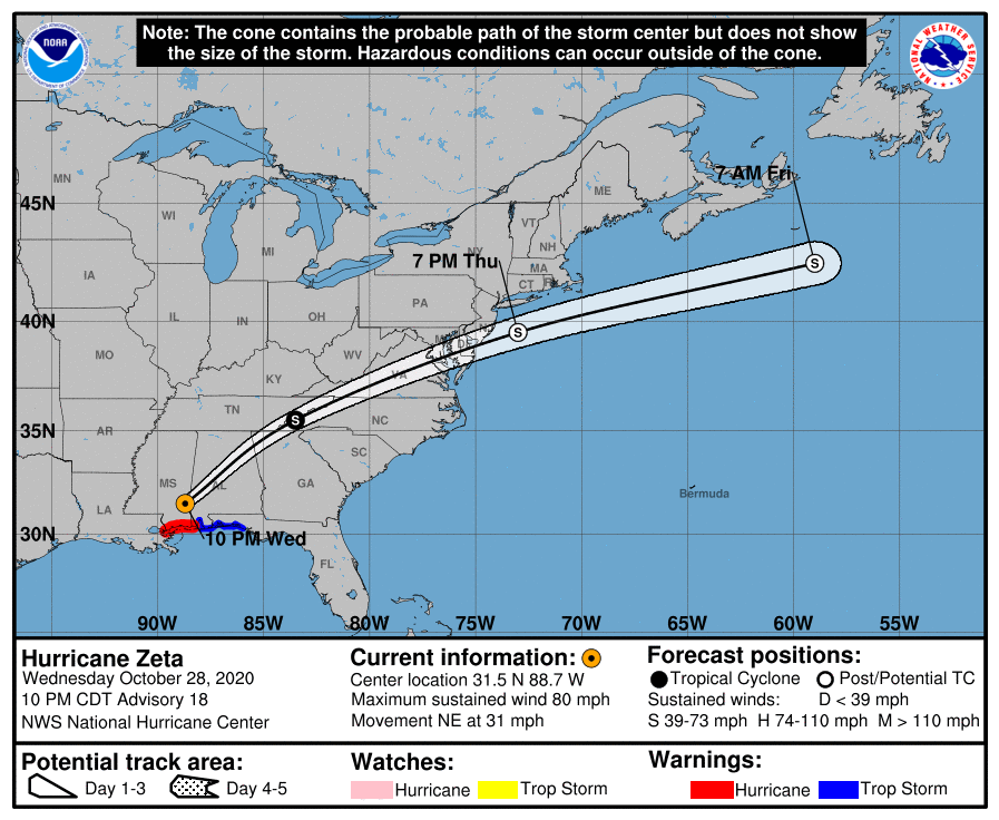
LOCATION…31.5N 88.7W
ABOUT 45 MI…70 KM NE OF HATTIESBURG MISSISSIPPI
MAXIMUM SUSTAINED WINDS…80 MPH…130 KM/H
PRESENT MOVEMENT…NE OR 40 DEGREES AT 31 MPH…50 KM/H
MINIMUM CENTRAL PRESSURE…979 MB…28.91 INCHES
WATCHES AND WARNINGS
——————–
CHANGES WITH THIS ADVISORY:
The Hurricane and Storm Surge Warnings have been discontinued for
all of Louisiana, including Lake Borgne and Lake Pontchartrain.
SUMMARY OF WATCHES AND WARNINGS IN EFFECT:
A Storm Surge Warning is in effect for…
* Mouth of the Pearl River to Navarre Florida
* Pensacola Bay and Mobile Bay
A Hurricane Warning is in effect for…
* Mouth of the Pearl River to the Mississippi/Alabama border
A Tropical Storm Warning is in effect for…
* Mississippi/Alabama border to Walton/Bay County Line Florida
DISCUSSION AND OUTLOOK
———————-
At 1000 PM CDT (0300 UTC), the center of Hurricane Zeta was located
near latitude 31.5 North, longitude 88.7 West. Zeta is moving toward
the northeast near 31 mph (50 km/h). An even faster northeastward
motion is expected overnight through Thursday, then a rapid
east-northeastward motion is anticipated through Friday. On the
forecast track, the center of Zeta will move into southern Alabama
soon and then move quickly across the southeastern eastern United
States through Thursday before emerging offshore of Mid-Atlantic
coast late Thursday.
Maximum sustained winds have decreased to near 80 mph (130 km/h)
with higher gusts. Further weakening is expected, and Zeta should
decay into a tropical storm overnight and into a non-tropical
gale-force low Thursday morning. The low should become absorbed by
a frontal system over the western Atlantic on Friday.
Hurricane-force winds extend outward up to 25 miles (35 km) from the
center and tropical-storm-force winds extend outward up to 150 miles
(240 km). Mobile Regional Airport recently;y reported sustained
winds of 48 mph (78 km/h) and a wind gust of 91 mph (146 km/h).
The estimated minimum central pressure is 979 mb (28.91 inches).
HAZARDS AFFECTING LAND
———————-
Key messages for Zeta can be found in the Tropical Cyclone
Discussion under AWIPS header MIATCDAT3, WMO header WTNT43 KNHC, and
on the web at www.hurricanes.gov/text/MIATCDAT3.shtml.
STORM SURGE: Along the northern Gulf Coast, the combination of a
dangerous storm surge and the tide will cause normally dry areas
near the coast to be flooded by rising waters moving inland from the
shoreline. The water could reach the following heights above ground
somewhere in the indicated areas if the peak surge occurs at the
time of high tide…
East of the Mouth of the Pearl River to Dauphin Island AL…4-7 ft
Mobile Bay…4-6 ft
Dauphin Island AL to AL/FL border…3-5 ft
AL/FL border to Navarre FL including Pensacola Bay…2-4 ft
Mouth of the Atchafalaya River to the Mouth of the Pearl
River…1-3 ft
Lake Maurepas, Lake Pontchartrain, and Lake Borgne…1-3 ft
Navarre FL to Yankeetown FL including Choctawhatchee Bay and Saint
Andrew Bay…1-3 ft
The deepest water will occur along the immediate coast near and to
the right of the landfall location, where the surge will be
accompanied by large and destructive waves. Surge-related flooding
depends on the relative timing of the surge and the tidal cycle,
and can vary greatly over short distances. For information
specific to your area, please see products issued by your local
National Weather Service forecast office.
WIND: Hurricane or Tropical Storm conditions are expected to
continue within the Warning areas near the northern Gulf Coast
overnight.
Damaging winds, especially in gusts, will spread well inland across
portions of southeastern Mississippi, Alabama, and northern Georgia
this evening through early Thursday morning, and into the Carolinas
and southeastern Virginia on Thursday. Wind gusts could be
especially severe across the southern Appalachian Mountains on
Thursday.
RAINFALL: Areas of heavy rainfall, both in advance of Zeta and
along the track of Zeta, will impact areas from the central Gulf
Coast to the Mid-Mississippi and Ohio Valleys, and east into the
southern to central Appalachians and Mid-Atlantic through Thursday.
Rainfall totals of 2 to 4 inches with isolated amounts of 6 inches
are expected across these areas, resulting in flash, urban, small
stream, and minor river flooding.
TORNADOES: A few tornadoes are possible overnight over parts of
southern Alabama and the western Panhandle of Florida. An isolated
tornado or two is possible tomorrow across much of the Carolinas and
southern Virginia.
Category: Alabama's Weather, ALL POSTS, Severe Weather, Tropical
About the Author (Author Profile)
Scott Martin is an operational meteorologist, professional graphic artist, musician, husband, and father. Not only is Scott a member of the National Weather Association, but he is also the Central Alabama Chapter of the NWA president. Scott is also the co-founder of Racecast Weather, which provides forecasts for many racing series across the USA. He also supplies forecasts for the BassMaster Elite Series events including the BassMaster Classic.Subscribe
If you enjoyed this article, subscribe to receive more just like it.


