

A Quick North/Central Alabama Update Before 11:00 pm, Including Impacts
RADAR CHECK AT 10:40 PM
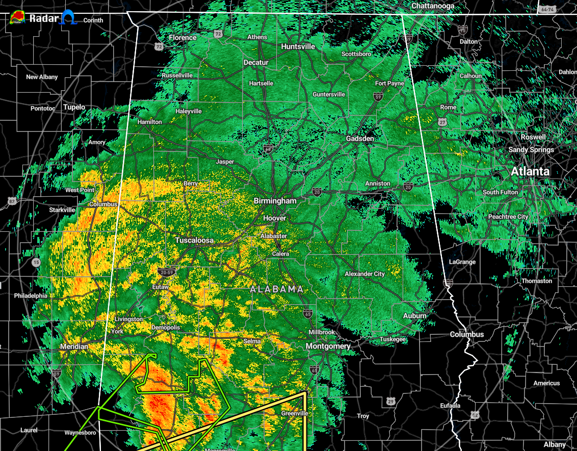
The heaviest rain associated with Hurricane Zeta remains over the southwestern quarter of North/Central Alabama, but we can now see the center moving over the state line just south of the area over Choctaw and Washington counties. Much of the rest of North/Central Alabama has light rain falling at the moment. Winds are behaving at the moment, but we are starting to see wind gusts over 30 MPH in Demopolis and Selma.
TIMING OF HIGH WINDS: Southwest of a line from Fayette to Tuscaloosa to Troy, the timing for the worst of the weather will be from 8:00 pm to 3:00 am. Peak wind gusts can range from 20 MPH in the northwest to near 70 mph in the south-central parts of this area. Northeast of that line to a line from Cullman to Anniston to Roanoke, the timing for the worst of the weather will be from midnight to around 4:00 am with peak wind ranging from 20 MPH in the northwestern parts to near 70 mph in the central and east-central parts of the area. For the northeast corner of Central Alabama (northeast of a line from Cullman to Anniston to Roanoke), we can expect peak wind gusts of 40 to 65 MPH in the window of 2:00 am to 6:00 am.
CURRENT WATCHES, WARNINGS, & ADVISORIES
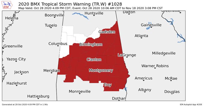
TROPICAL STORM WARNING: NWS Birmingham continues the Tropical Storm Warning for Etowah, Cherokee, Jefferson, St. Clair, Calhoun, Cleburne, Tuscaloosa, Shelby, Talladega, Clay, Randolph, Bibb, Sumter, Greene, Hale, Perry, Chilton, Coosa, Tallapoosa, Chambers, Marengo, Dallas, Autauga, Elmore, Lee, Lowndes, Montgomery, Macon, Russell, Pike, Bullock, and Barbour counties in Central Alabama until further notice.
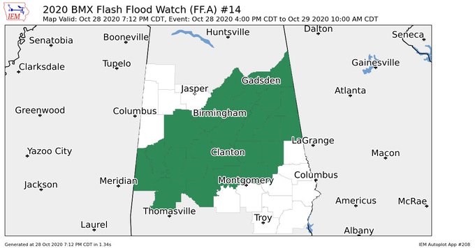
FLASH FLOOD WATCHES: NWS Birmingham continues the Flash Flood Watch for Etowah, Cherokee, Jefferson, St. Clair, Calhoun, Cleburne, Tuscaloosa, Shelby, Talladega, Clay, Randolph, Bibb, Sumter, Greene, Hale, Perry, Chilton, Coosa, Tallapoosa, Marengo, Dallas, Autauga, and Elmore counties in Central Alabama until 10:00 am Thursday.
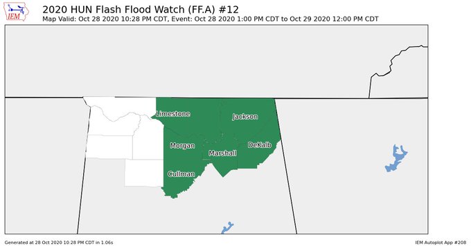
NWS Huntsville continues the Flash Flood Watch for Cullman, DeKalb, Jackson, Limestone, Madison, Marshall, AND Morgan counties in North Alabama until 12:00 pm Thursday.
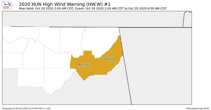
HIGH WIND WARNING: NWS Huntsville has issued a HIGH WIND WARNING for DeKalb and Marshall counties in North Alabama starting at 2:00 am and set to expire at 6:00 am. Sustained east to northeast winds around 45 mph with gusts of 60 to 65 mph can be expected within the warning area, especially in elevated terrain.
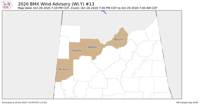
WIND ADVISORIES: NWS Birmingham continues a WIND ADVISORY until 7:00 am Thursday for Blount, Fayette, Pickens, and Walker counties in North Alabama.
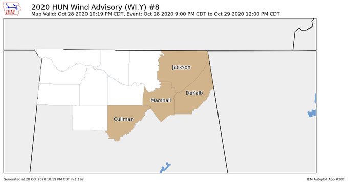
NWS Huntsville continues a WIND ADVISORY for Cullman, DeKalb, Jackson, and Marshall counties in North Alabama until 12:00 pm Thursday.
POTENTIAL IMPACTS
WIND
- Some damage to roofing and siding materials, along with damage to porches, awnings, carports, and sheds. A few buildings experiencing window, door, and garage door failures. Mobile homes damaged, especially if unanchored. Unsecured lightweight objects become dangerous projectiles.
- Several large trees snapped or uprooted, but with greater numbers in places where trees are shallow-rooted. Several fences and roadway signs blown over.
- Some roads impassable from large debris, and more within urban or heavily wooded places. A few bridges, causeways, and access routes impassable.
- Scattered power and communications outages, but more prevalent in areas with above-ground lines.
RAIN
- Moderate rainfall flooding may prompt several evacuations and rescues.
- Rivers and tributaries may quickly become swollen with swifter currents and overspill their banks in a few places, especially in usually vulnerable spots. Small streams, creeks, canals, arroyos, and ditches overflow.
- Flood waters can enter some structures or weaken foundations. Several places may experience expanded areas of rapid inundation at underpasses, low-lying spots, and poor drainage areas. Some streets and parking lots take on moving water as storm drains and retention ponds overflow. Driving conditions become hazardous. Some road and bridge closures.
TORNADOES
- The occurrence of isolated tornadoes can hinder the execution of emergency plans during tropical events.
- A few places may experience tornado damage, along with power and communications disruptions.
- Locations could realize roofs peeled off buildings, chimneys toppled, mobile homes pushed off foundations or overturned, large tree tops and branches snapped off, shallow-rooted trees knocked over, moving vehicles blown off roads, and boats pulled from moorings.
CURRENT POWER OUTAGES: For the state of Alabama, there are over 134,000 customers without power at this point. If you add that to Louisiana and Mississippi’s combined total of over 753,000, the grand total affected by Zeta is over 887,000 customers.
SCHOOL DELAYS: Find the list of current delays for the local school systems by clicking HERE.
Category: Alabama's Weather, ALL POSTS, Severe Weather, Tropical
About the Author (Author Profile)
Scott Martin is an operational meteorologist, professional graphic artist, musician, husband, and father. Not only is Scott a member of the National Weather Association, but he is also the Central Alabama Chapter of the NWA president. Scott is also the co-founder of Racecast Weather, which provides forecasts for many racing series across the USA. He also supplies forecasts for the BassMaster Elite Series events including the BassMaster Classic.Subscribe
If you enjoyed this article, subscribe to receive more just like it.


