

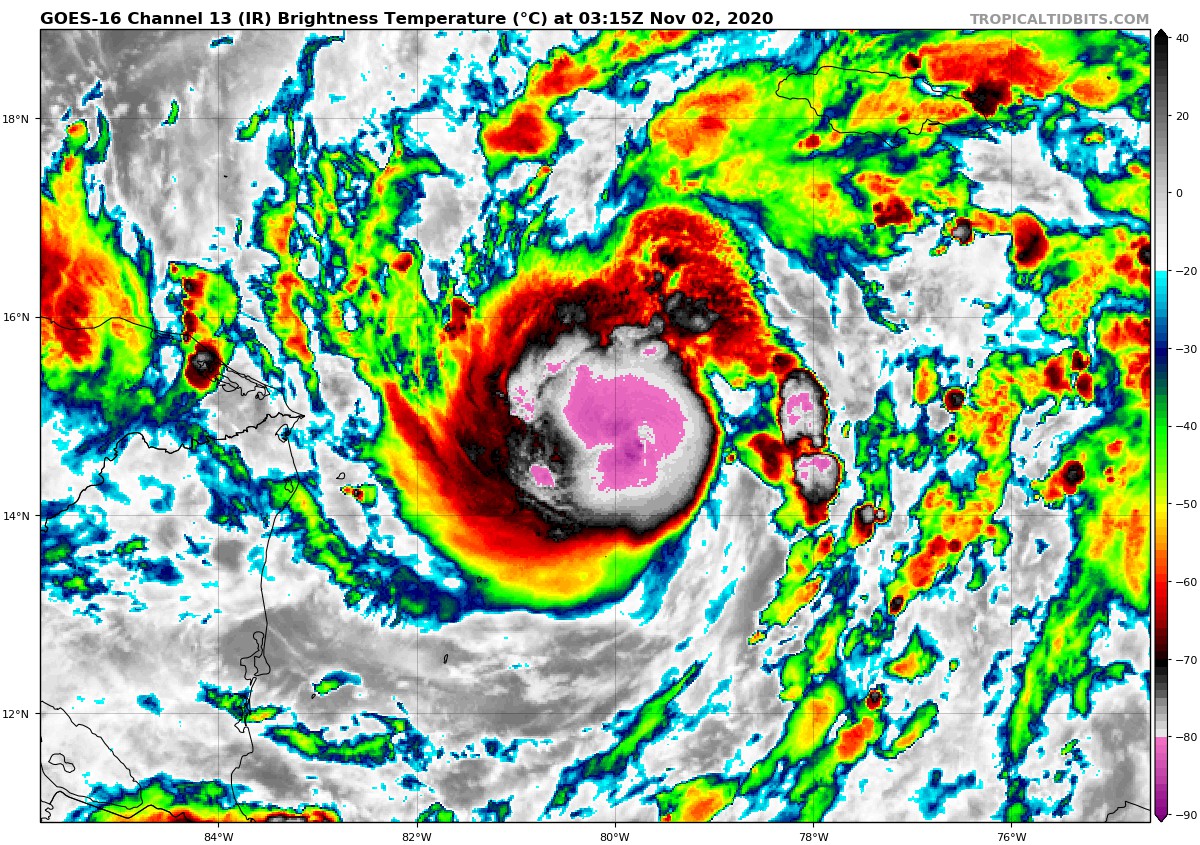
Eta Nearing Hurricane Strength
BULLETIN
Tropical Storm Eta Advisory Number 6
NWS National Hurricane Center Miami FL AL292020
1000 PM EST Sun Nov 01 2020
…ETA CLOSE TO BECOMING A HURRICANE…
…LIFE-THREATENING STORM SURGE, DAMAGING WINDS, AND FLASH FLOODING
AND LANDSLIDES EXPECTED ACROSS PORTIONS OF CENTRAL AMERICA…
SUMMARY OF 1000 PM EST…0300 UTC…INFORMATION
———————————————–
LOCATION…14.9N 80.0W
ABOUT 215 MI…345 KM E OF CABO GRACIAS A DIOS ON NIC/HON BORDER
ABOUT 235 MI…380 KM ENE OF PUERTO CABEZAS NICARAGUA
MAXIMUM SUSTAINED WINDS…70 MPH…110 KM/H
PRESENT MOVEMENT…W OR 270 DEGREES AT 13 MPH…20 KM/H
MINIMUM CENTRAL PRESSURE…989 MB…29.21 INCHES
WATCHES AND WARNINGS
——————–
CHANGES WITH THIS ADVISORY:
None.
SUMMARY OF WATCHES AND WARNINGS IN EFFECT:
A Hurricane Warning is in effect for…
* The coast of Nicaragua from the Honduras/Nicaragua border to
Sandy Bay Sirpi
A Tropical Storm Warning is in effect for…
* The northeastern coast of Honduras from Punta Patuca to the
Honduras/Nicaragua border
A Hurricane Watch is in effect for…
* The northeastern coast of Honduras from Punta Patuca to the
Honduras/Nicaragua border
A Tropical Storm Watch is in effect for…
* The northern coast of Honduras from west of Punta Patuca westward
to Punta Castilla
A Hurricane Warning means that hurricane conditions are expected
somewhere within the warning area. A warning is typically issued
36 hours before the anticipated first occurrence of
tropical-storm-force winds, conditions that make outside
preparations difficult or dangerous. Preparations to protect life
and property should be rushed to completion.
A Tropical Storm Warning means that tropical storm conditions are
expected somewhere within the warning area within 36 hours.
A Hurricane Watch means that hurricane conditions are possible
within the watch area. A watch is typically issued 48 hours
before the anticipated first occurrence of tropical-storm-force
winds, conditions that make outside preparations difficult or
dangerous.
A Tropical Storm Watch means that tropical storm conditions are
possible within the watch area, generally within 48 hours.
Interests elsewhere in Nicaragua and Honduras should monitor the
progress of this system.
For storm information specific to your area, please monitor
products issued by your national meteorological service.
DISCUSSION AND OUTLOOK
———————-
At 1000 PM EST (0300 UTC), the center of Tropical Storm Eta was
located near latitude 14.9 North, longitude 80.0 West. Eta is moving
toward the west near 13 mph (20 km/h), and this general motion is
expected to continue through Monday morning. A slower motion toward
the west-southwest is forecast by Monday afternoon and continuing
into Tuesday. On the forecast track, the center of Eta is expected
to approach the northeastern coast of Nicaragua Monday afternoon,
and make landfall within the Hurricane Warning area in Nicaragua
Monday night or early Tuesday. The center of Eta is forecast to move
farther inland over northern Nicaragua through early Wednesday.
Maximum sustained winds are near 70 mph (110 km/h) with higher
gusts. Rapid strengthening is forecast to continue during the next
36 hours, and Eta is expected to become a hurricane by early Monday
morning. Additional strengthening is likely thereafter, and Eta is
expected to be a major hurricane when landfall occurs Monday night
or early Tuesday. An Air Force Reserve reconnaissance aircraft will
be investigating Eta later tonight.
Tropical-storm-force winds extend outward up to 140 miles (220 km)
from the center.
The estimated minimum central pressure is 989 mb (29.21 inches).
HAZARDS AFFECTING LAND
———————-
Key messages for Eta can be found in the Tropical Cyclone
Discussion under AWIPS header MIATCDAT4 and WMO header
WTNT44 KNHC.
WIND: Hurricane conditions are expected in the Hurricane Warning
area beginning Monday night, with tropical storm conditions
possible in this area by Monday afternoon. Tropical storm
conditions are expected in the Tropical Storm Warning area by
Monday afternoon, and hurricane conditions are possible in
the Hurricane Watch area by early Tuesday. Tropical Storm
conditions are possible in the Tropical Storm Watch area by early
Tuesday.
RAINFALL: Eta is expected to produce the following rainfall amounts
through Friday evening:
Much of Nicaragua and Honduras: 15 to 25 inches (380 to 635 mm),
isolated amounts of 35 inches (890 mm).
Eastern Guatemala and southern Belize: 10 to 20 inches (255 to 510
mm), isolated amounts of 25 inches (635 mm).
Portions of Panama and Costa Rica: 10 to 15 inches (255 to 380 mm),
isolated amounts of 25 inches (635 mm).
Jamaica and southeast Mexico: 5 to 10 inches (125 to 255 mm),
isolated amounts of 15 inches (380 mm) over southern areas.
El Salvador, Southern Haiti, and the Cayman Islands: 3 to 5 inches
(75 to 125 mm), isolated amounts of 10 inches (255 mm)
This rainfall would lead to catastrophic, life-threatening flash
flooding and river flooding, along with landslides in areas of
higher terrain of Central America. Flash flooding and river
flooding would be possible across Jamaica, southeast Mexico, El
Salvador, southern Haiti, and the Cayman Islands.
STORM SURGE: A dangerous storm surge will raise water levels by as
much as 10 to 15 feet above normal tide levels in areas of onshore
winds along the coast of Nicaragua within the hurricane warning
area, and 3 to 5 feet above normal tide levels along the coast of
Honduras within the tropical storm warning area. Near the coast,
the surge will be accompanied by large and destructive waves.
SURF: Swells generated by Eta are expected to affect portions of
the coast of Central America and the Yucatan Peninsula of Mexico
during the next few days. These swells are likely to cause
life-threatening surf and rip current conditions. Please consult
products from your local weather office.
NEXT ADVISORY
————-
Next intermediate advisory at 100 AM EST.
Next complete advisory at 400 AM EST.
$$
Forecaster Stewart
About the Author (Author Profile)
Bill Murray is the President of The Weather Factory. He is the site's official weather historian and a weekend forecaster. He also anchors the site's severe weather coverage. Bill Murray is the proud holder of National Weather Association Digital Seal #0001 @wxhistorianSubscribe
If you enjoyed this article, subscribe to receive more just like it.


