

Eta Continues to Rapidly Intensify as it Approaches the Northeastern Coast of Nicaragua
SUMMARY OF 700 PM EST…0000 UTC…INFORMATION
———————————————-
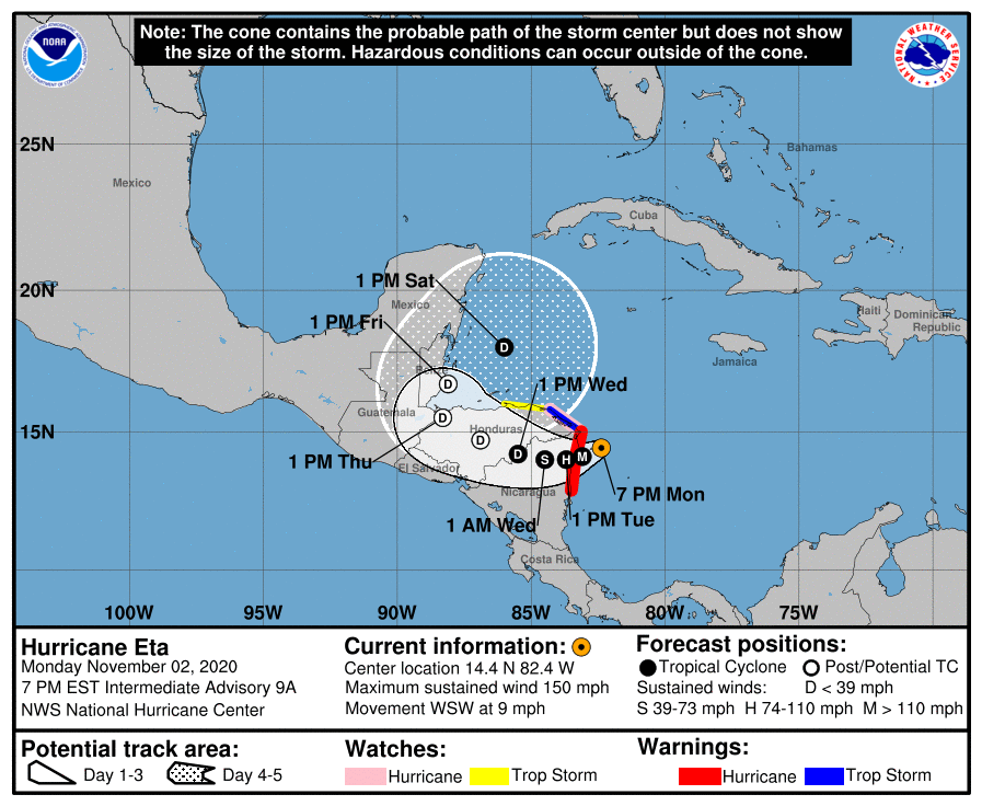
LOCATION…14.4N 82.4W
ABOUT 70 MI…110 KM ESE OF CABO GRACIAS A DIOS ON NIC/HON BORDER
ABOUT 70 MI…115 KM ENE OF PUERTO CABEZAS NICARAGUA
MAXIMUM SUSTAINED WINDS…150 MPH…240 KM/H
PRESENT MOVEMENT…WSW OR 250 DEGREES AT 9 MPH…15 KM/H
MINIMUM CENTRAL PRESSURE…934 MB…27.58 INCHES
WATCHES AND WARNINGS
——————–
A Hurricane Warning is in effect for…
* The coast of Nicaragua from the Honduras/Nicaragua border to
Sandy Bay Sirpi
A Tropical Storm Warning is in effect for…
* The northeastern coast of Honduras from Punta Patuca to the
Honduras/Nicaragua border
A Hurricane Watch is in effect for…
* The northeastern coast of Honduras from Punta Patuca to the
Honduras/Nicaragua border
A Tropical Storm Watch is in effect for…
* The northern coast of Honduras from west of Punta Patuca westward
to Punta Castilla
DISCUSSION AND OUTLOOK
———————-
At 700 PM EST (0000 UTC), the center of Hurricane Eta was located
near latitude 14.4 North, longitude 82.4 West. Eta is moving toward
the west-southwest near 9 mph (15 km/h), and this general motion is
expected to continue through early Tuesday. A slower westward or
west-northwestward motion is forecast to begin by Tuesday afternoon
and continue through Thursday. On the forecast track, the center of
Eta is expected to make landfall along the coast of Nicaragua within
the Hurricane Warning area early Tuesday. The center of Eta is
forecast to move farther inland over northern Nicaragua through
Wednesday night, and then move across central portions of Honduras
on Thursday.
Maximum sustained winds have increased to near 150 mph (240 km/h)
with higher gusts. Eta is a category 4 hurricane on the Saffir-
Simpson Hurricane Wind Scale. Additional strengthening is forecast
until Eta reaches the coast of Nicaragua. Weakening will begin
after the cyclone moves inland. An Air Force Reserve hurricane
hunter aircraft is currently en route to investigate Eta.
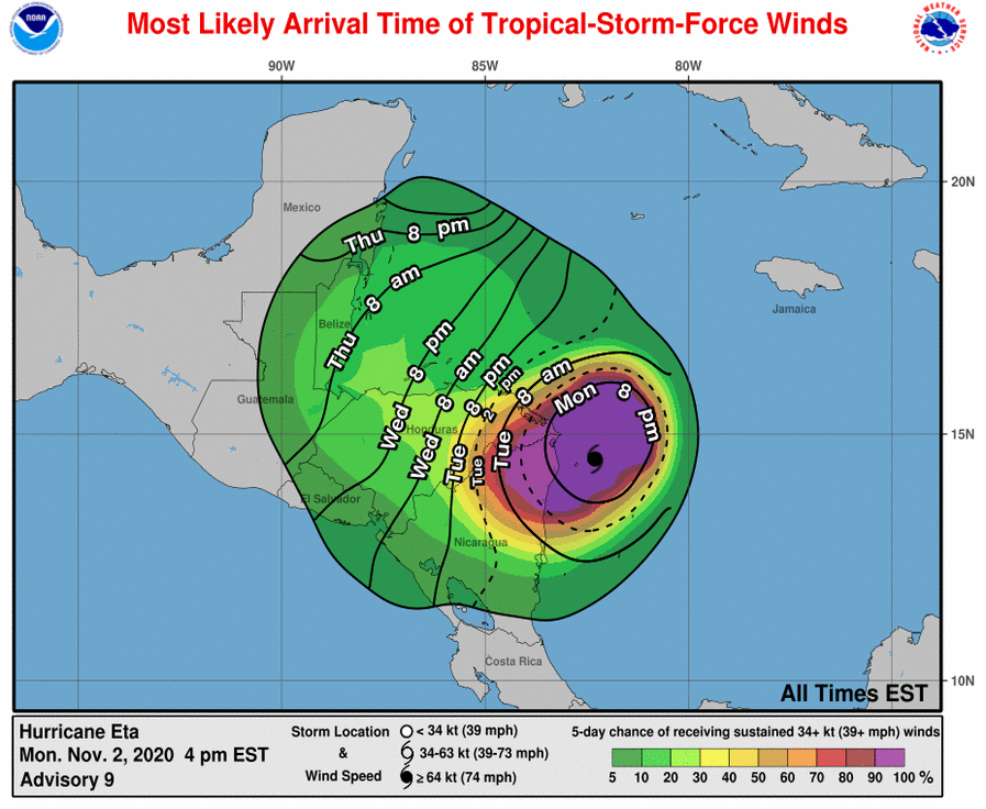
Hurricane-force winds extend outward up to 25 miles (35 km) from
the center and tropical-storm-force winds extend outward up to 125
miles (205 km).
The estimated minimum central pressure is 934 mb (27.58 inches).
HAZARDS AFFECTING LAND
———————-
WIND: Catastrophic wind damage is expected where Eta’s eyewall
moves onshore within the Hurricane Warning area beginning tonight,
with tropical storm conditions beginning within the next few hours.
Tropical storm conditions are expected in the Tropical Storm Warning
area tonight, and hurricane conditions are possible in the Hurricane
Watch area by early Tuesday. Tropical Storm conditions are possible
in the Tropical Storm Watch area by early Tuesday.
RAINFALL: Eta is expected to produce the following rainfall amounts
through Friday evening:
Much of Nicaragua and Honduras: 15 to 25 inches (380 to 635 mm),
isolated amounts of 35 inches (890 mm).
Eastern Guatemala and Belize: 10 to 20 inches (255 to 510 mm),
isolated amounts of 25 inches (635 mm).
Portions of Panama and Costa Rica: 10 to 15 inches (255 to 380 mm),
isolated amounts of 25 inches (635 mm).
Jamaica and southeast Mexico: 5 to 10 inches (125 to 255 mm),
isolated amounts of 15 inches (380 mm) over southern areas.
El Salvador, Southern Haiti, and the Cayman Islands: 3 to 5 inches
(75 to 125 mm), isolated amounts of 10 inches (255 mm)
This rainfall will lead to catastrophic, life-threatening flash
flooding and river flooding, along with landslides in areas of
higher terrain of Central America. Flash flooding and river
flooding are also possible across Jamaica, southeast Mexico, El
Salvador, southern Haiti, and the Cayman Islands.
STORM SURGE: A dangerous storm surge will raise water levels by as
much as 12 to 18 feet above normal tide levels in areas of onshore
winds along the coast of Nicaragua within the hurricane warning
area, and 3 to 5 feet above normal tide levels along the coast of
Honduras within the tropical storm warning area. Near the coast,
the surge will be accompanied by large and destructive waves.
SURF: Swells generated by Eta are expected to affect portions of
the coast of Central America and the Yucatan Peninsula of Mexico
during the next few days. These swells are likely to cause
life-threatening surf and rip current conditions. Please consult
products from your local weather office.
Category: ALL POSTS, Severe Weather, Tropical
About the Author (Author Profile)
Scott Martin is an operational meteorologist, professional graphic artist, musician, husband, and father. Not only is Scott a member of the National Weather Association, but he is also the Central Alabama Chapter of the NWA president. Scott is also the co-founder of Racecast Weather, which provides forecasts for many racing series across the USA. He also supplies forecasts for the BassMaster Elite Series events including the BassMaster Classic.Subscribe
If you enjoyed this article, subscribe to receive more just like it.


