Very Dangerous Hurricane Eta Continues to Slowly Move Closer to Nicaragua
SUMMARY OF 1000 AM EST…1500 UTC…INFORMATION
———————————————–
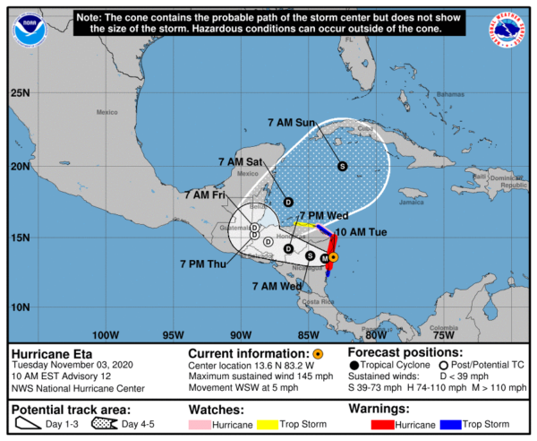
LOCATION…13.6N 83.2W
ABOUT 30 MI…50 KM SSE OF PUERTO CABEZAS NICARAGUA
MAXIMUM SUSTAINED WINDS…145 MPH…230 KM/H
PRESENT MOVEMENT…WSW OR 255 DEGREES AT 5 MPH…7 KM/H
MINIMUM CENTRAL PRESSURE…938 MB…27.70 INCHES
WATCHES AND WARNINGS
——————–
A Hurricane Warning is in effect for…
* The coast of Nicaragua from the Honduras/Nicaragua border to
Sandy Bay Sirpi
A Tropical Storm Warning is in effect for…
* The northeastern coast of Honduras from Punta Patuca to the
Honduras/Nicaragua border
* The coast of Nicaragua from south of Sandy Bay Sirpi to Laguna
de Perlas.
A Hurricane Watch is in effect for…
* The northeastern coast of Honduras from Punta Patuca to the
Honduras/Nicaragua border
A Tropical Storm Watch is in effect for…
* The northern coast of Honduras from west of Punta Patuca westward
to Punta Castilla
DISCUSSION AND OUTLOOK
———————-
At 1000 AM EST (1500 UTC), the center of Hurricane Eta was located
near latitude 13.6 North, longitude 83.2 West. Eta is moving toward
the west-southwest near 5 mph (7 km/h). A westward or
west-northwestward motion is forecast to begin later today and
continue through Thursday. On the forecast track, the center of
Eta is expected to make landfall along the coast of Nicaragua
within the Hurricane Warning area today. The center of Eta
is forecast to move farther inland over northern Nicaragua through
Wednesday morning, and then move across the central portions of
Honduras by Thursday morning.
Maximum sustained winds are near 145 mph (230 km/h) with higher
gusts. Eta is a category 4 hurricane on the Saffir-Simpson
Hurricane Wind Scale. Little change in strength is likely before
landfall. Weakening will begin after the center moves inland later
today.
Hurricane-force winds extend outward up to 25 miles (35 km) from the
center and tropical-storm-force winds extend outward up to 115 miles
(185 km).
The estimated minimum central pressure is 938 mb (27.70 inches).
HAZARDS AFFECTING LAND
———————-
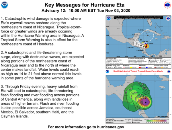
WIND: Catastrophic wind damage is expected where Eta’s eyewall
moves onshore within the Hurricane Warning area within the next
few hours, with tropical storm conditions already occuring in this
area. Tropical storm conditions are expected in the Tropical
Storm Warning area this morning, and hurricane conditions are
possible in the Hurricane Watch area. Tropical Storm conditions
are possible in the Tropical Storm Watch area later today.
RAINFALL: Eta is expected to produce the following rainfall amounts
through Sunday morning:
Much of Nicaragua and Honduras: 15 to 25 inches (380 to 635 mm),
isolated amounts of 35 inches (890 mm).
Eastern Guatemala and Belize: 10 to 20 inches (255 to 510 mm),
isolated amounts of 25 inches (635 mm).
Portions of Panama and Costa Rica: 10 to 15 inches (255 to 380 mm),
isolated amounts of 25 inches (635 mm).
El Salvador and southeast Mexico: 5 to 10 inches (125 to 255 mm),
isolated amounts of 15 inches (380 mm)
Jamaica, Southern Haiti, the Cayman Islands: An additional 3 to 5
inches (75 to 125 mm), isolated storm totals of 15 inches (380 mm).
This rainfall will lead to catastrophic, life-threatening flash
flooding and river flooding, along with landslides in areas of
higher terrain of Central America. Flash flooding and river
flooding will be possible across Jamaica, southeast Mexico, El
Salvador, southern Haiti, and the Cayman Islands.
STORM SURGE: A dangerous storm surge will raise water levels by as
much as 14 to 21 feet above normal tide levels in areas of onshore
winds along the coast of Nicaragua within the hurricane warning
area, and 3 to 5 feet above normal tide levels along the coast of
Honduras within the tropical storm warning area. Near the coast,
the surge will be accompanied by large and destructive waves.
SURF: Swells generated by Eta are expected to affect portions of
the coast of Central America and the Yucatan Peninsula of Mexico
during the next few days. These swells are likely to cause
life-threatening surf and rip current conditions. Please consult
products from your local weather office.
Category: ALL POSTS, Severe Weather, Tropical


