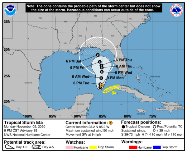
Eta Expected to Strengthen as It Meanders Over the Southeastern Gulf of Mexico on Tuesday
SUMMARY OF 900 PM CST…0300 UTC…INFORMATION
———————————————-
LOCATION…23.2N 85.2W
ABOUT 180 MI…285 KM SW OF THE DRY TORTUGAS
ABOUT 90 MI…150 KM NNW OF THE WESTERN TIP OF CUBA
MAXIMUM SUSTAINED WINDS…50 MPH…85 KM/H
PRESENT MOVEMENT…SW OR 225 DEGREES AT 9 MPH…15 KM/H
MINIMUM CENTRAL PRESSURE…995 MB…29.39 INCHES
WATCHES AND WARNINGS
——————–
CHANGES WITH THIS ADVISORY:
None.
SUMMARY OF WATCHES AND WARNINGS IN EFFECT:
A Tropical Storm Watch is in effect for…
* The Cuban provinces of La Habana, Artemisa, Mayabeque, Pinar del
Rio, and the Isle of Youth
A Tropical Storm Watch means that tropical storm conditions are
possible within the watch area, in this case within 36 hours.
Interests along the Gulf Coast of Florida should monitor the
progress of Eta.
For storm information specific to your area, please monitor
products issued by your national meteorological service.
DISCUSSION AND OUTLOOK
———————-
At 900 PM CST (0300 UTC), the center of Tropical Storm Eta was
located near latitude 23.2 North, longitude 85.2 West. Eta is moving
toward the southwest near 9 mph (15 km/h), and this motion with
a reduction in forward speed is expected tonight. Little overall
motion is forecast on Tuesday and a slow northward motion is
expected Tuesday night and Wednesday. On the forecast track, the
center of Eta will remain over the southeastern Gulf of Mexico
tonight through Wednesday.
Maximum sustained winds are near 50 mph (85 km/h) with higher gusts.
Some strengthening will be possible tonight and Tuesday. Gradual
weakening is expected to begin by late Wednesday and then continue
through the end of the week.
Tropical-storm-force winds extend outward up to 115 miles (185 km)
from the center.
The estimated minimum central pressure is 995 mb (29.39 inches).
HAZARDS AFFECTING LAND
———————-
Key messages for Eta can be found in the Tropical Cyclone Discussion
under AWIPS header MIATCDAT4, WMO header WTNT44 KNHC, and on the
web at www.hurricanes.gov/text/MIATCDAT4.shtml.
RAINFALL: Eta is expected to produce the following rainfall amounts
through Saturday morning:
The Bahamas: An additional 1 to 2 inches (25 to 50 mm), with
isolated maximum storm totals of 15 inches (380 mm).
Portions of Cuba: an additional 3 to 5 inches (75 to 125 mm),
isolated maximum storm total accumulations of 25 inches (635 mm).
Portions of the central and southern Florida peninsula, including
the Keys: an additional 1 to 3 inches (25 to 75 mm), with isolated
maximum storm totals of 18 inches (450 mm) in South Florida.
Flash and river flooding will be possible in Cuba, along with
landslides in areas of higher terrain. Additional flash and urban
flooding, especially across previously inundated areas, will be
possible in South Florida tonight. Flash and urban flooding will
also be possible for the Bahamas and the remainder of southern and
eastern Florida over the next several days.
WIND: Gusty conditions will continue across the Florida Keys, south
and central Florida, and the northwestern Bahamas tonight. Tropical
storm conditions are possible in the Tropical Storm Watch area in
Cuba tonight and Tuesday.
SURF: Swells generated by Eta are expected to affect the north
coast of Cuba, the northwestern Bahamas, southern Florida and the
Florida Keys during the next day or so. These swells are likely to
cause life-threatening surf and rip current conditions. Please
consult products from your local weather office.


