

Eta Meandering Just Off the Coast of Western Cuba
…ETA MEANDERING JUST OFF THE COAST OF WESTERN CUBA…
…RISK OF FLOODING OVER SOUTH FLORIDA AND WESTERN CUBA CONTINUES…
SUMMARY OF 900 AM CST…1500 UTC…INFORMATION
———————————————-
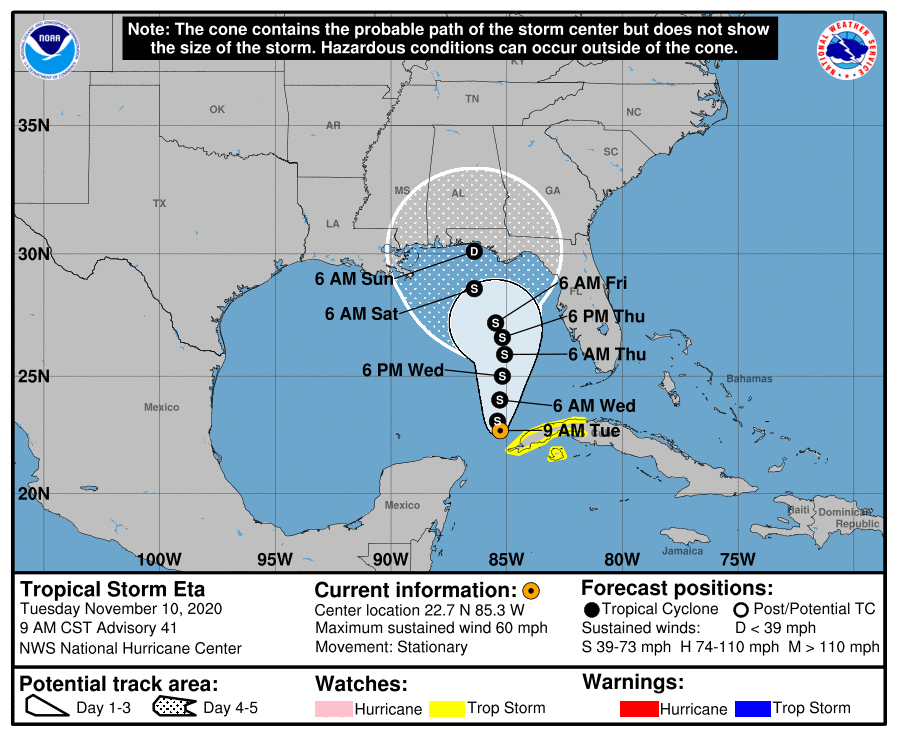
LOCATION…22.7N 85.3W
ABOUT 60 MI…100 KM NNW OF THE WESTERN TIP OF CUBA
MAXIMUM SUSTAINED WINDS…60 MPH…95 KM/H
PRESENT MOVEMENT…STATIONARY
MINIMUM CENTRAL PRESSURE…992 MB…29.30 INCHES
WATCHES AND WARNINGS
——————–
A Tropical Storm Watch is in effect for…
* The Cuban provinces of La Habana, Artemisa, Mayabeque, Pinar del
Rio, and the Isle of Youth
DISCUSSION AND OUTLOOK
———————-
At 900 AM CST (1500 UTC), the center of Tropical Storm Eta was
located near latitude 22.7 North, longitude 85.3 West. Eta has been
nearly stationary this morning, and little motion is expected today.
A slow northward motion is forecast to begin by this evening and
continue through Thursday.
Maximum sustained winds are near 60 mph (95 km/h) with higher gusts.
Some strengthening is forecast during the next day or two, followed
by weakening likely starting on Thursday.
Tropical-storm-force winds extend outward up to 60 miles (95 km)
from the center.
The estimated minimum central pressure is 992 mb (29.30 inches).
HAZARDS AFFECTING LAND
———————-
RAINFALL: Eta is expected to produce the following rainfall amounts
today and tonight:
Western Cuba: an additional 3 to 5 inches (75 to 125 mm), with
isolated maximum storm total accumulations of 25 inches (765 mm).
South Florida: an additional 1 to 2 inches (25 to 50 mm), with
isolated maximum storm total accumulations of 20 inches (510 mm).
Flash and river flooding will be possible in western Cuba, along
with landslides in areas of higher terrain. Additional flash and
urban flooding, especially across previously inundated areas, will
be possible in South Florida today and tonight.

WIND: Tropical storm conditions are possible in the Tropical Storm
Watch area in Cuba today.
SURF: Swells generated by Eta are expected to affect the north
coast of Cuba, the northwestern Bahamas, southern and western
Florida, and the Florida Keys during the next day or so. These
swells are likely to cause life-threatening surf and rip current
conditions. Please consult products from your local weather office.
About the Author (Author Profile)
Scott Martin is an operational meteorologist, professional graphic artist, musician, husband, and father. Not only is Scott a member of the National Weather Association, but he is also the Central Alabama Chapter of the NWA president. Scott is also the co-founder of Racecast Weather, which provides forecasts for many racing series across the USA. He also supplies forecasts for the BassMaster Elite Series events including the BassMaster Classic.Subscribe
If you enjoyed this article, subscribe to receive more just like it.


