

Midday Nowcast: Clearing Sky Through the Afternoon
It has been a cloudy morning, but the sky is clearing and will continue to clear through the afternoon hours as drier air filters into the state. We are already seeing a sunny sky in northwest Alabama late this morning.
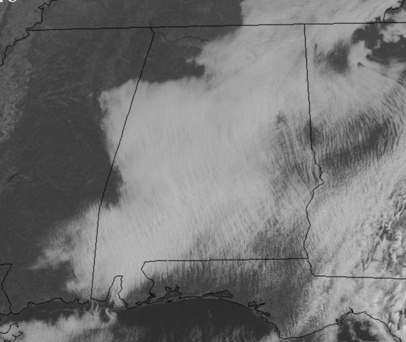
Expect lower humidity and somewhat cooler temps with upper 60s and lower 70s this afternoon. A clear and chilly night ahead with lows falling into the mid and upper 40s. Tomorrow will feature sunshine in full supply with highs in the lower 70s for most North/Central Alabama communities.
ETA MAKES LANDFALL: At Cedar Key, Florida this morning, with winds of 50 mph. Eta is moving toward the north-northeast near 15 mph and a faster northeastward motion is expected over the next couple of days. On the forecast track, the center of Eta will emerge into the western Atlantic by early this afternoon. The cyclone is expected to accelerate over the western Atlantic and move parallel to, but offshore of the Carolinas tonight and early Friday before heading well east of the Mid-Atlantic coast by late Friday.
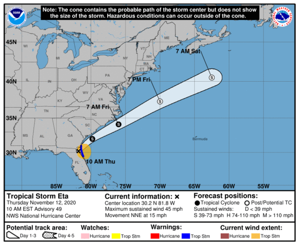
Maximum sustained winds are near 45 mph with higher gusts. Little change in strength is forecast through early Friday. Eta could re-intensify as a non-tropical cyclone late Friday or Friday night before becoming absorbed by a larger non-tropical cyclone on Saturday.
Tropical-storm-force winds extend outward up to 115 miles primarily over water to the east of the center. A NOAA Coastal Marine Observing site at St. Augustine Florida reported sustained winds of 39 mph and a gust of 44 mph. A wind gust to 43 mph was recently reported at the Mayport Naval Air Station near Jacksonville, Florida. The estimated minimum central pressure is 1003 mb (29.62 inches).
ELSEWHERE IN THE TROPICS: Theta continues to move across the eastern Atlantic and will not impact the U.S. It is moving east at 12 mph and has winds of 65 mph.
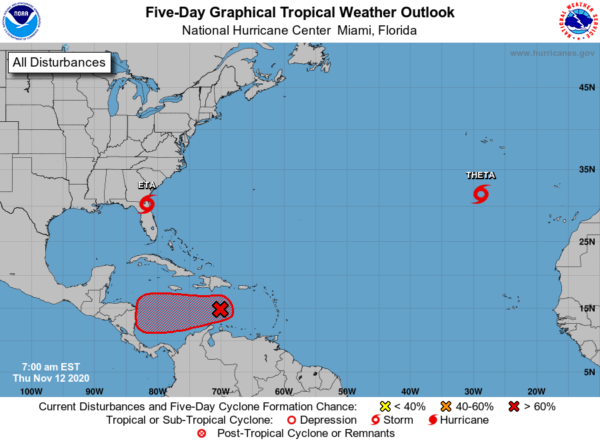
Future Iota: A tropical wave located over the central Caribbean Sea continues to produce a large area of showers and thunderstorms. Satellite imagery indicates that the disturbance is gradually becoming better organized, and a tropical depression will likely form within the next couple of days as it moves slowly westward over the central and western Caribbean Sea. Regardless of development, this system is expected to bring heavy rainfall along with possible flash flooding to portions of Hispaniola over the next day or so. Formation chance through 5 days…high…90 percent.
BEACH FORECAST CENTER: Get the latest weather and rip current forecasts for the beaches from Fort Morgan to Panama City on our Beach Forecast Center page. There, you can select the forecast of the region that you are interested in visiting.
WORLD TEMPERATURE EXTREMES: Over the last 24 hours, the highest observation outside the U.S. was 114.8F at Maun, Botswana. The lowest observation was -61.8F at Dome A, Antarctica.
CONTIGUOUS TEMPERATURE EXTREMES: Over the last 24 hours, the highest observation was 91F at Falcon Lake, TX. The lowest observation was -17F at Copper Basin, ID.
WEATHER ON THIS DATE IN 1974: A great Alaska storm in the Bering Sea caused the worst coastal flooding of memory at Nome AK with a tide of 13.2 feet. The flooding caused 12 million dollars damage, however no lives are lost.
Category: Alabama's Weather, ALL POSTS
About the Author (Author Profile)
Macon, Georgia Television Chief Meteorologist, Birmingham native, and long time Contributor on AlabamaWX. Stormchaser. I did not choose Weather, it chose Me. College Football Fanatic. @Ryan_StinnetSubscribe
If you enjoyed this article, subscribe to receive more just like it.


