

Midday Nowcast: Sunshine, Blue Sky, & Tropical Depression 31
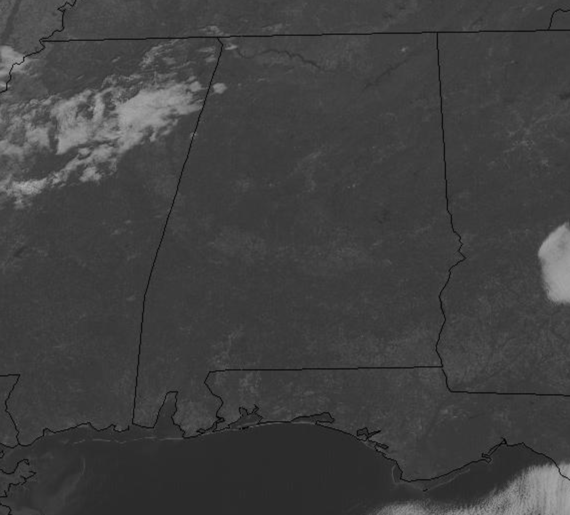
After the foggy start to the day, we are seeing sunshine in full supply across the state and temperatures are in the upper 60s and lower 70s as we roll into the afternoon. Tonight, will be a clear and chilly one with lows back down into the lower and mid 40s.
WONDERFUL WEEKEND WEATHER: For tomorrow, expect a splendid Saturday of weather as the sky will be full of sunshine and afternoon highs will return to the low to mid 70s. Another front approaches the area Sunday, so clouds will be on the increase and a few showers are possible, but limited moisture means most locations will remain dry, and any rain showers will be very light and spotty. Highs Sunday will be on either side of 70°.
IN THE TROPICS: Eta has become post-tropical and continues to head out to sea off the Carolina Coast. Theta, maintains winds of 60 mph as it tracks east across the eastern Atlantic.
TROPICAL DEPRESSION 31: This will become Iota soon…The center of Tropical Depression Thirty-One was located near latitude 14.2 North, longitude 74.3 West. The depression is moving toward the west-southwest near 7 mph and this motion is expected to continue through early Saturday. A westward to west-northwestward motion at a slightly faster forward speed is expected to begin by late Saturday and continue through early Monday. On the forecast track, the system will move across the central Caribbean Sea during the next day or so, and approach the coasts of Nicaragua and northeastern Honduras late Sunday and Monday.
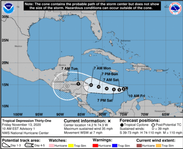
Maximum sustained winds are near 35 mph with higher gusts. The depression is forecast to strengthen into a tropical storm later today or tonight. Additional strengthening is likely over the weekend, and the system could be near major hurricane strength when it approaches Central America. The estimated minimum central pressure is 1007 mb (29.74 inches).
LEONID METEOR SHOWER PEAKS: From midnight to dawn this weekend watch for meteors in the annual Leonid meteor shower. The new moon Sunday guarantees a dark sky in rural locations on the shower’s peak mornings. The meteors are expected to fall most abundantly in the dark hours before dawn on Tuesday, but you should see several over the weekend. At the shower’s peak, you might see as many as 10 to 15 meteors per hour.
BEACH FORECAST CENTER: Get the latest weather and rip current forecasts for the beaches from Fort Morgan to Panama City on our Beach Forecast Center page. There, you can select the forecast of the region that you are interested in visiting.
WORLD TEMPERATURE EXTREMES: Over the last 24 hours, the highest observation outside the U.S. was 113.4F at Fitzroy Crossing Aero, Australia. The lowest observation was -61.4F at Dome A, Antarctica.
CONTIGUOUS TEMPERATURE EXTREMES: Over the last 24 hours, the highest observation was 93F at Rio Grande Village, TX. The lowest observation was -23F at Peter Sinks, UT.
WEATHER ON THIS DATE IN 1933: The first dust storm of the great dust bowl era of the 1930s occurred. The dust storm, which had spread from Montana to the Ohio Valley the day before, prevailed from Georgia to Maine resulting in a black rain over New York and a brown snow in Vermont. Parts of South Dakota, Minnesota and Iowa reported zero visibility on the 12th. On the 13th, dust reduced the visibility to half a mile in Tennessee.
Category: Alabama's Weather, ALL POSTS
About the Author (Author Profile)
Macon, Georgia Television Chief Meteorologist, Birmingham native, and long time Contributor on AlabamaWX. Stormchaser. I did not choose Weather, it chose Me. College Football Fanatic. @Ryan_StinnetSubscribe
If you enjoyed this article, subscribe to receive more just like it.


