

Very Nice at Midday; A Few Showers Possible Overnight & Into Sunday
WEATHER FOR THE REST OF YOUR SATURDAY
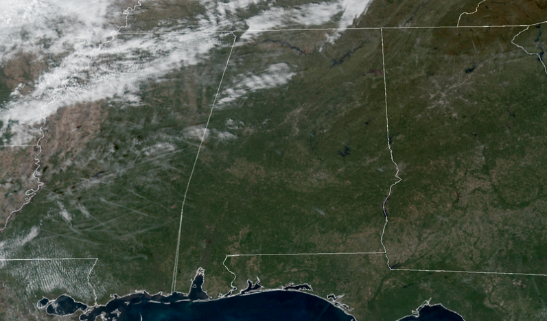
As 12:00 pm, other than a few clouds rolling across the northwestern parts of Central Alabama, your midday hour on Saturday is full of sunshine and feeling really nice. Temperatures were in the upper 60s to the upper 70s across the area. Birmingham was at 74 degrees. The warm spot was Troy at 77 degrees. Gadsden is keeping it cool as the cool spot at 68 degrees.
We’ll have plenty of sunshine across Central Alabama, but clouds will be on the increase from the west and northwest throughout the afternoon and into the evening hours. Afternoon highs will range from the lower 70s in the north to the upper 70s in the south. Clouds will continue to increase during the late-night and overnight hours as a cold front will be approaching. A few showers may be possible west of the I-59 corridor during the overnight hours. Lows will be in the mid-50s to the lower 60s.
SUNDAY’S WEATHER
A cold front will quickly move through Central Alabama on Sunday, but with very dry air in place, there is only a small chance of a few showers during the morning and possibly into the early afternoon hours for locations north of the US-80 and I-85 corridors with the higher chances north of I-20. Once the front moves out by the afternoon, skies will begin to slowly clear out and temperatures will start to steadily fall. Highs will range from the mid-60s in the northwest to the upper 70s in the southeast.
THE TROPICS
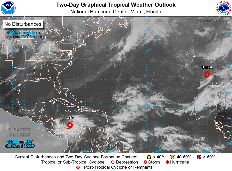
As of the 12:00 pm NHC update, the center of Tropical Storm Iota was located by an Air Force Reserve reconnaissance aircraft around 375 miles south of Kingston, Jamaica. Iota is moving toward the west-southwest near 5 MPH. A westward motion with some increase in forward speed is expected to begin later today and continue through Monday. On the forecast track, Iota will move across the southwest Caribbean Sea during the next day or so, and approach the coasts of Nicaragua and northeastern Honduras on Monday. Preliminary data from an Air Force Reserve Hurricane Hunter aircraft indicate that the maximum sustained winds are near 50 MPH with higher gusts. Steady to rapid strengthening is likely to begin tonight or Sunday, and Iota is forecast to be at or near major hurricane strength when it approaches Central America.
The government of Nicaragua has issued a Hurricane Watch from Sandy Bay Sirpi northward to the Honduras/Nicaragua border. The government of Honduras has issued a Hurricane Watch from the Honduras/Nicaragua border westward to Punta Patuca. A Tropical Storm Watch has been issued from west of Punta Patuca westward to Punta Castilla. The government of Colombia has issued a Hurricane Watch for the island of Providencia.
Through Thursday, heavy rainfall from Iota will likely lead to life-threatening flash flooding and river flooding across portions of northern Colombia and Central America. Flooding and mudslides in Honduras and Nicaragua could be exacerbated by Hurricane Eta’s recent effects there, resulting in significant impacts.
As of the 10:00 am NHC update, the center of Tropical Storm Theta was located around 575 miles southeast of The Azores. Theta is moving toward the east near 8 mph (13 km/h), and this general motion with a gradual decrease in forward speed is expected through Sunday. A sharp northward turn is forecast to occur Sunday night, with that motion continuing into early next week. Maximum sustained winds are near 40 mph (65 km/h) with higher gusts. Weakening is expected over the next few days, and Theta is forecast to become a remnant low by tonight, and dissipate early next week.
The rest of the Atlantic Basin is quiet for now.
Category: ALL POSTS
About the Author (Author Profile)
Scott Martin is an operational meteorologist, professional graphic artist, musician, husband, and father. Not only is Scott a member of the National Weather Association, but he is also the Central Alabama Chapter of the NWA president. Scott is also the co-founder of Racecast Weather, which provides forecasts for many racing series across the USA. He also supplies forecasts for the BassMaster Elite Series events including the BassMaster Classic.Subscribe
If you enjoyed this article, subscribe to receive more just like it.


