

12:00 am Update: Major Jump in Wind Speeds as Iota is Now a Major Hurricane
RECONNAISSANCE AIRCRAFT FINDS IOTA HAS RAPIDLY STRENGTHENED INTO
A DANGEROUS MAJOR HURRICANE.
EXPECTED TO BRING POTENTIALLY CATASTROPHIC WINDS, LIFE-THREATENING STORM SURGE, AND EXTREME RAINFALL IMPACTS TO CENTRAL AMERICA.
SUMMARY OF 100 AM EST…0600 UTC…INFORMATION
———————————————-
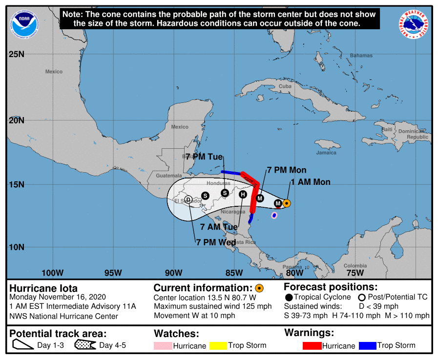
LOCATION…13.5N 80.7W
ABOUT 45 MI…70 KM ENE OF ISLA DE PROVIDENCIA COLOMBIA
ABOUT 190 MI…310 KM ESE OF CABO GRACIAS A DIOS ON NIC/HON BORDER
MAXIMUM SUSTAINED WINDS…125 MPH…205 KM/H
PRESENT MOVEMENT…W OR 280 DEGREES AT 10 MPH…17 KM/H
MINIMUM CENTRAL PRESSURE…945 MB…27.91 INCHES
WATCHES AND WARNINGS
——————–
A Hurricane Warning is in effect for…
* Providencia
* The coast of Nicaragua from the Honduras/Nicaragua border to
Sandy Bay Sirpi
* The coast of northeastern Honduras from Punta Patuca to the
Honduras/Nicaragua border
A Hurricane Watch is in effect for…
* San Andres
A Tropical Storm Warning is in effect for…
* San Andres
* The coast of Nicaragua from south of Sandy Bay Sirpi to Bluefields
* The northern coast of Honduras from west of Punta Patuca to Punta
Castilla
DISCUSSION AND OUTLOOK
———————-
At 100 AM EST (0600 UTC), the center of Hurricane Iota was located
by an Air Force Reserve reconnaissance aircraft near latitude 13.5
North, longitude 80.7 West. Iota is moving toward the west near 10
mph (17 km/h). A westward to west-northwestward motion is expected
through landfall. After landfall, a westward to west-southwestward
motion is forecast. On the forecast track, the core of Iota will
pass near or over Providencia island during the next few hours, and
make landfall within the hurricane warning area in northeastern
Nicaragua and eastern Honduras tonight.
Reports from the aircraft indicate that maximum sustained winds
have increased to near 125 mph (205 km/h) with higher gusts. Iota is
now a category 3 hurricane on the Saffir-Simpson Hurricane Wind
Scale. Rapid strengthening is expected during the next 24 hours, and
Iota is forecast to be an extremely dangerous category 4 hurricane
when it approaches Central America tonight.
Hurricane-force winds extend outward up to 35 miles (55 km) from
the center and tropical-storm-force winds extend outward up to 150
miles (240 km).
The latest data from the reconnaissance aircraft indicate that the
minimum central pressure is 945 mb (27.91 inches).
HAZARDS AFFECTING LAND
———————-
RAINFALL: Iota is expected to produce the following rainfall
accumulations through Friday morning:
Honduras, northern Nicaragua, Guatemala, southern Belize: 8 to 16
inches (200 to 400 mm). Isolated maximum totals of 20-30 inches (500
to 750 mm) will be possible, especially from northeast Nicaragua
into northern Honduras.
Costa Rica and Panama: 4 to 8 inches (100 to 200 mm), with isolated
maximum totals of 12 inches (300 mm).
This rainfall would lead to significant, life-threatening flash
flooding and river flooding, along with mudslides in areas of higher
terrain.
El Salvador and southern Nicaragua: 3 to 5 inches (75 to 125 mm),
with isolated maximum totals of 10 inches (250 mm).
Northern Colombia: An additional 1 to 3 inches (25 to 75 mm), with
isolated maximum totals near 12 inches (300 mm).
WIND: Potentially catastrophic wind damage is expected where Iota’s
eyewall moves onshore within the Hurricane Warning area in Nicaragua
and Honduras beginning late tonight with tropical storm conditions
expected this morning. Hurricane conditions are expected on
the island of Providencia shortly with tropical storm conditions
expected to continue through this morning and possibly into the
early afternoon. Tropical storm conditions are expected to begin on
the island of San Andres shortly with hurricane conditions possible
there later this morning. Tropical storm conditions are expected in
the Tropical Storm Warning area in Nicaragua by late afternoon and
in the warning area in Honduras by tonight.
STORM SURGE: A life-threatening storm surge will raise water levels
by as much as 10 to 15 feet above normal tide levels in areas of
onshore winds along the coast of Nicaragua and Honduras. Near the
coast, the surge will be accompanied by large and destructive waves.
SURF: Swells generated by Iota will affect much of the coast of
Central America, the Yucatan Peninsula, Jamaica, and Colombia during
the next couple of days. These swells are likely to cause
life-threatening surf and rip current conditions. Please consult
products from your local weather office.
Category: ALL POSTS, Severe Weather, Tropical
About the Author (Author Profile)
Scott Martin is an operational meteorologist, professional graphic artist, musician, husband, and father. Not only is Scott a member of the National Weather Association, but he is also the Central Alabama Chapter of the NWA president. Scott is also the co-founder of Racecast Weather, which provides forecasts for many racing series across the USA. He also supplies forecasts for the BassMaster Elite Series events including the BassMaster Classic.Subscribe
If you enjoyed this article, subscribe to receive more just like it.


