

Quiet Pattern Through Early Next Week; A Few Isolated Showers Sunday
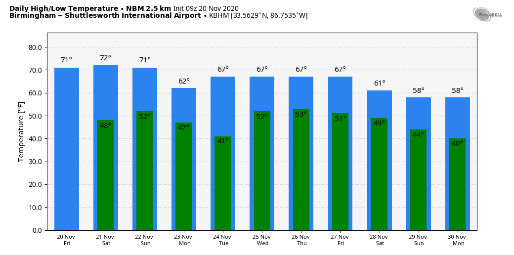
ANOTHER SUNNY DAY: Today will be the fifth consecutive day with a sunny sky for Alabama as a dry airmass remains in place. We expect a high around 70 degrees this afternoon; the average high for Birmingham on November 20 is 64. We rise into the low 70s tomorrow as the weekend begins with a good supply of sunshine. Then, on Sunday, moisture levels will rise a bit, and a cold front will approach from the north. We will mention a chance of isolated showers Sunday afternoon into Sunday night for the northern half of the state, but rain amounts, if any, will be light and spotty.
For most of the state, the high Sunday will be in the low 70s, but cooler air could invade the Tennessee Valley of North Alabama earlier in the day behind the front, keeping afternoon temperatures in the low to mid 60s.
THANKSGIVING WEEK: Monday and Tuesday will be dry with a good supply of sunshine both days; the high Monday will be in the mid 60s, and close to 70 Tuesday. Then, a fairly dynamic weather system will bring a batch of rain and thunderstorms to the state Wednesday.
This will be your typical November system with lots of shear, but little instability. No doubt a few strong storms are possible, but it still remains to be seen if we will have any severe weather threat. We will have much better clarity over the weekend. Rain amounts Wednesday should be around one inch for much of the state. Then, dry air returns for Thanksgiving Day and “Black Friday” with highs in the 60s. See the Weather Xtreme video for maps, graphics, and more details.
FOOTBALL WEATHER: For the high school playoff games tonight, the sky will be clear with temperatures falling through the 50s. Tomorrow, Alabama hosts Kentucky (3:00p CT kickoff at Bryant Denny Stadium)… the sky will be sunny with temperatures in the low 70s at kickoff, falling back into the 60s during the second half.
Auburn hosts Tennessee tomorrow evening (6:00p kickoff at Jordan Hare Stadium)… a great night for football with a clear sky. Temperatures will fall from the low 60s at kickoff, into the upper 50s by the final whistle.
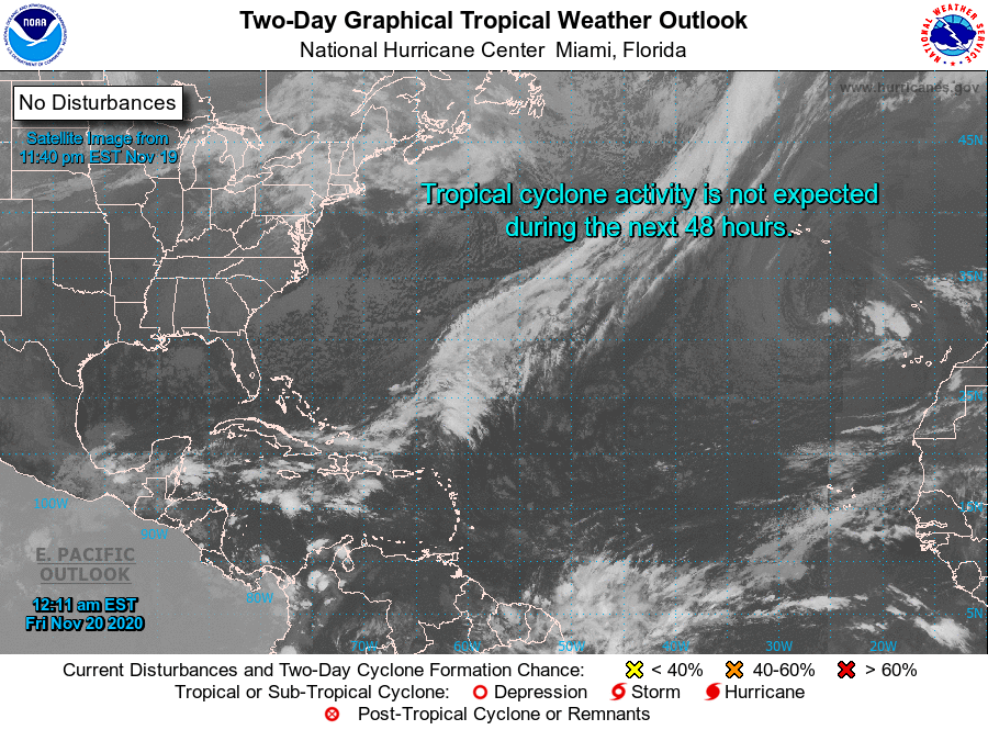
TROPICS: All is mostly quiet across the Atlantic basin this morning. NHC is still monitoring a disturbance northeast of the Bahamas in the Atlantic, but it has only a low chance of development over the next five days.
ON THIS DATE IN 1900: A tornado outbreak in the Lower Mississippi Valley resulted in 73 deaths and extensive damage across Arkansas, Mississippi, and Tennessee. The strongest tornado of the evening struck the town of Columbia, in Maury County, Tennessee; 27 people were killed there.
ON THIS DATE IN 1985: Kate intensified to a major Category 3 Hurricane and as she moved west of Key West, Florida with top winds of 115 mph and a minimum central pressure of 954 millibars or 28.17 inches of mercury. The next day Kate made landfall between Panama City and Apalachicola, Florida. Tides ran 8 to 10 feet above normal. Many power poles and lines were downed. Several roads were washed out.
BEACH FORECAST: Click here to see the AlabamaWx Beach Forecast Center page.
WEATHER BRAINS: Don’t forget you can listen to our weekly 90 minute show anytime on your favorite podcast app. This is the show all about weather featuring many familiar voices, including our meteorologists here at ABC 33/40.
CONNECT: You can find me on all of the major social networks…
Look for the next Weather Xtreme video here by 4:00 this afternoon… enjoy the day!
Category: Alabama's Weather, ALL POSTS, Weather Xtreme Videos
About the Author (Author Profile)
James Spann is one of the most recognized and trusted television meteorologists in the industry. He holds the AMS CCM designation and television seals from the AMS and NWA. He is a past winner of the Broadcast Meteorologist of the Year from both professional organizations.Subscribe
If you enjoyed this article, subscribe to receive more just like it.


