

Sunny Today; Showers/Storms Return Tomorrow
COLD START: Here are some temperatures across Alabama just before sunrise…
Decatur 29
Hueytown 31
Meridianville 31
Haleyville 31
Demopolis 32
Fort Payne 32
Weaver 32
Pell City 32
Huntsville 33
Heflin 33
Good Hope 33
Prattville 33
Sylacauga 33
Bessemer 33
Gadsden 34
Scottsboro 34
Tuscaloosa 35
Montgomery 35
Northport 35
Anniston 37
Black Creek 37
Cullman 39
Mobile 43
Birmingham 43
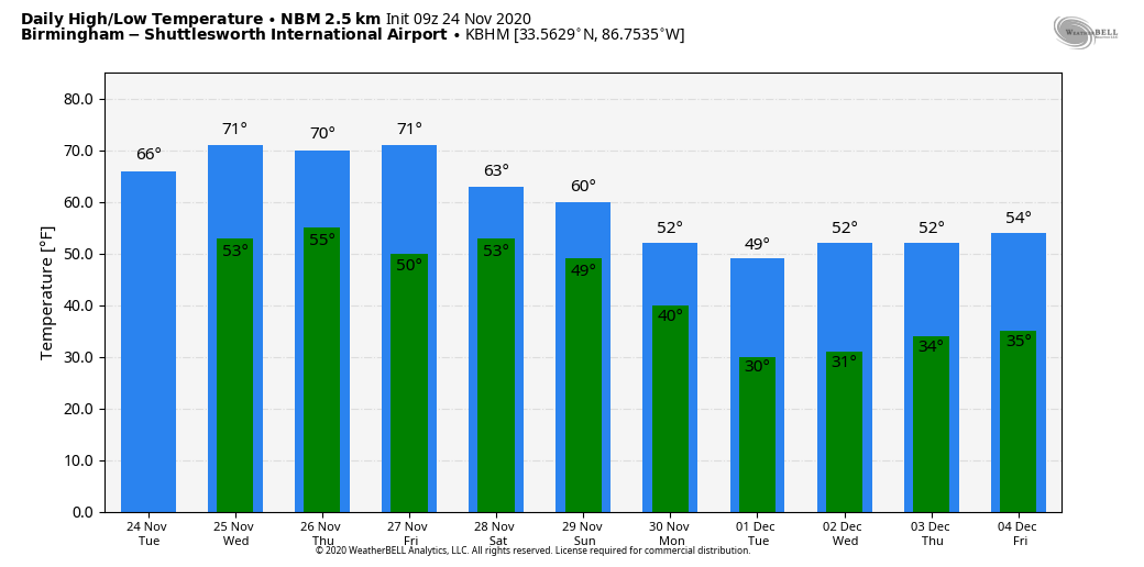
Today will be a mostly sunny day with a high between 67 and 70 degrees. Clouds will increase tonight.
SHOWERS/STORMS RETURN: Tomorrow will be a cloudy day with a high in the low 70s; showers and storms will likely begin to develop by afternoon ahead of a cold front. SPC has identified a low end, “marginal risk” (level 1/5) for much of North and Central Alabama…
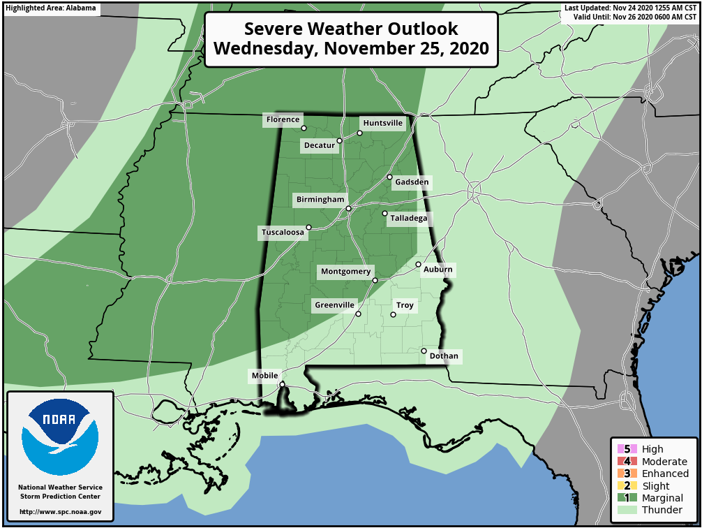
A few storms late tomorrow afternoon and tomorrow evening could produce small hail and strong gusty winds, but for now the overall severe weather threat looks pretty low with the highest shear well removed from the highest instability (which is not especially high anyway). Rain amounts of 1/2 to 1 inch look likely for most communities.
THANKSGIVING/FRIDAY: The surface front will become stationary across Central Alabama Thursday morning, and at this point it looks like the best chance of showers on Thanksgiving Day will come over the southern half of the state. The day will be cloudy and mild with a high in the 70s. Then, on Friday, a wave forms along the front, and rain will increase statewide by afternoon. We will reach the mid 70s Friday, about 10 degrees above average for late November in Alabama.
THE ALABAMA WEEKEND: The wave will move northeast of the state, and the front gets a nudge southward again Saturday. This could very well mean the best chance of rain Saturday will be over the southern half of the state, but we will continue to mention a few periods of rain statewide until we get better clarity. It won’t rain all day Saturday, and we don’t expect any severe weather issues. The high over North Alabama will be in the 60s, with 70s for the southern counties of the state.
Sunday another wave forms on the front, and rain will increase statewide. The GFS (American global model) suggests it will be a very cool, rainy day with temperatures only in the 50s over North Alabama. But, the ECMWF (European global model) hints we could get in the warm sector by Sunday night with a chance of strong to severe storms. We will have a much better handle on the weekend situation once we get past the storms tomorrow night, but one way or another Sunday is looking very wet.
NEXT WEEK: The coldest air so far this season will roll into Alabama next week, with highs only in the 40s and 50s, and lows in the 20s and 30s. There is some signal from models that a surface low could form in the northern Gulf at mid-week with potential for some cold rain, followed by a deep upper low that might squeeze out a snow flake somewhere over North Alabama late in the week. Of course, this is nothing but voodoo right now. The big message for next week is the cold air. See the Weather Xtreme video for maps, graphics, and more details.
IRON BOWL: The biggest game of the year in Alabama kicks off at Bryant Denny Stadium in Tuscaloosa Saturday at 2:30. The sky will be cloudy; temperatures will be in the 65-70 degree range during the game. We will continue to mention a chance of showers even through models for the moment are hinting the best chance of rain will be south of Tuscaloosa, over the southern half of the state. If rain does fall, for the moment we aren’t expecting anything especially heavy, and no severe storms are expected.
UAB/SOUTHERN MISS: UAB will play their last game at Legion Field Friday against Southern Miss (11:30a CT kickoff)… the sky will be cloudy, and rain is possible during the game. Temperatures will rise from near 70 at kickoff, in to the mid 70s by the final whistle.
TROPICS: A broad area of low pressure located a couple of hundred miles south of Bermuda is producing showers and thunderstorms to the east of its center as it merges with a frontal system. By late Wednesday or Thursday, the system could become separated from the front, allowing it to possibly develop some subtropical characteristics later this week while it meanders over the central Atlantic. It won’t be a threat to the U.S… and the Gulf of Mexico remains quiet. The hurricane season ends in six days.
ON THIS DATE IN 2001: A total of 36 tornadoes touched down across Alabama; two people were killed in southern Lamar County in West Alabama, and there were two other fatalities near Sand Rock in Cherokee County. The strongest tornado of the day was an F4 that moved through parts of northern Blount and Etowah counties.
BEACH FORECAST: Click here to see the AlabamaWx Beach Forecast Center page.
WEATHER BRAINS: Don’t forget you can listen to our weekly 90 minute show anytime on your favorite podcast app. This is the show all about weather featuring many familiar voices, including our meteorologists here at ABC 33/40.
CONNECT: You can find me on all of the major social networks…
Look for the next Weather Xtreme video here by 4:00 this afternoon… enjoy the day!
Category: Alabama's Weather, ALL POSTS, Weather Xtreme Videos
About the Author (Author Profile)
James Spann is one of the most recognized and trusted television meteorologists in the industry. He holds the AMS CCM designation and television seals from the AMS and NWA. He is a past winner of the Broadcast Meteorologist of the Year from both professional organizations.Subscribe
If you enjoyed this article, subscribe to receive more just like it.


