

Strong/Severe Storms Tomorrow Afternoon/Night
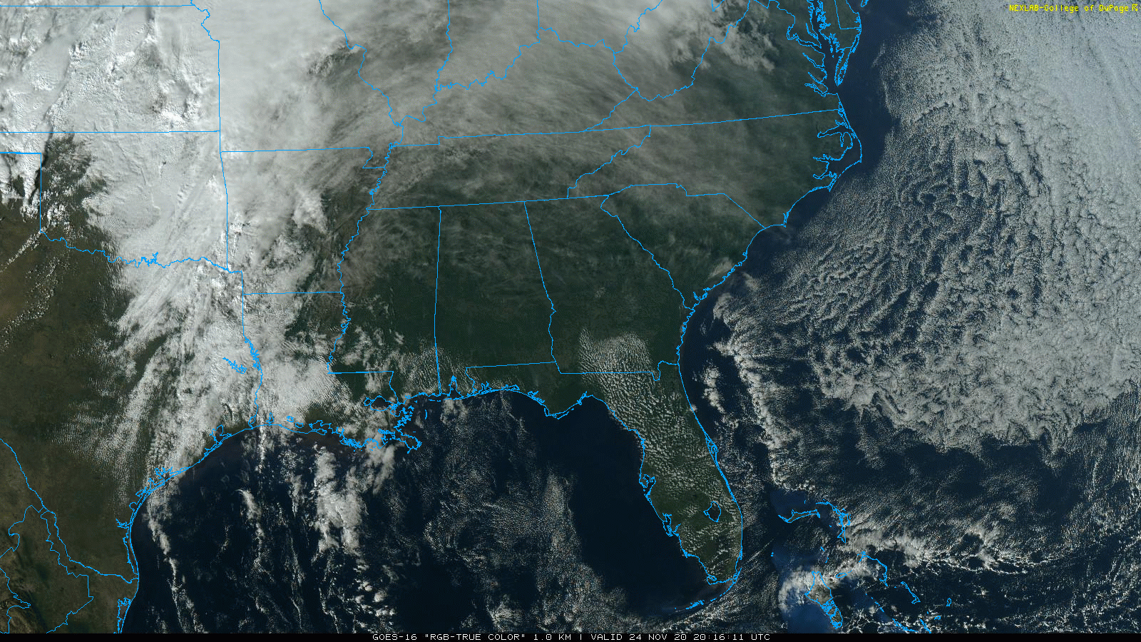
BEAUTIFUL AFTERNOON: Temperatures are in the 60s over most of Alabama this afternoon with a good supply sunshine. Clouds will gradually increase tonight; the low will be in the 50s.
STORMS RETURN: An approaching cold front will bring a round of showers and thunderstorms to Alabama tomorrow afternoon and tomorrow night. SPC maintains a “marginal risk” (level 1/5) for the northern 2/3 of the state.
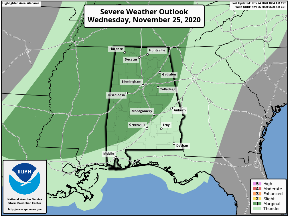
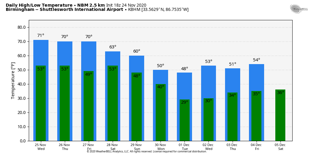
New model runs are a little more aggressive with the amount of surface based instability tomorrow evening with the front; heavier storms will be capable of producing some hail and strong gusty winds. An isolated, brief tornado or two can’t be ruled out; rain amounts of 1/2 to 1 inch are likely. Otherwise, tomorrow will be mostly cloudy and windy at times with a high in the low 70s. South winds could gust to 25/30 mph even with no thunderstorms involved.
THURSDAY/FRIDAY: The front stalls out over Central Alabama by Thursday morning; Thanksgiving Day looks dry for the northern half of the state with a high in the low to mid 70s; a few showers are possible over the southern counties of the state. Then, on Friday, a wave of low pressure forms on the front, and rain becomes likely statewide by afternoon and into Friday night.
THE ALABAMA WEEKEND: After the Friday night wave, the front gets another nudge southward, and models now show the front moving into far South Alabama Saturday. Meaning, much of the state is low looking dry Saturday with highs in the 60s over North Alabama, and 70s for the southern counties. Showers on Saturday should be limited to the southern 1/4 of Alabama, generally south of U.S. 84.
And, yet another wave forms on the front with a big statewide soaking Sunday and Sunday night. The main global models continue to disagree on the position of the low; the GFS (the American global model) keeps North Alabama in cool, stable air with temperatures in the 50s as the low passes to the north, but the ECMWF (European global model) depicts the low running from Tupelo to Knoxville, with some potential for strong storms Sunday night. One way or another it will be a big rain event with amounts of 2 inches likely. We will get better clarity on the potential for strong storms over the next few days.
NEXT WEEK: The coldest air so far this season will roll into Alabama Monday. Some places over North Alabama could hold in the 30s all day with an icy north wind; elsewhere highs will be in the 40s with a clearing sky. By Tuesday morning we expect lows in the 20s over the northern two-thirds of the state with a clear sky and diminishing wind.
An impulse at mid-week could squeeze out a few sprinkles or flurries Wednesday or Wednesday night, but for now it looks like moisture will be very limited, and precipitation amounts, if any, will be light. Thursday and Friday look dry… See the Weather Xtreme video for maps, graphics, and more details.
IRON BOWL: Based on new model data, we will be much more optimistic for the biggest game of the year in Alabama Saturday in Tuscaloosa at Bryant-Denny Stadium (2:30p CT kickoff). The sky will be mostly cloudy, but for now the weather is looking rain-free. A few intervals of sunshine are even possible; temperatures will be in the mid to upper 60s during the game.
UAB/SOUTHERN MISS: UAB plays their last game at Legion Field Friday against Southern Miss (11:30a CT kickoff). The sky will be mostly cloudy with temperatures in the low 70s. Some rain could arrive by the second half, but the heaviest rain most likely holds off until after the game is over.
TROPICS: A non-tropical area of low pressure located a couple of hundred miles south-southeast of Bermuda has merged with a frontal system and is producing gale-force winds, along with showers and thunderstorms to the east of its center. By Thursday, the system could become separated from the front, allowing it to possibly develop some subtropical characteristics later this week while it meanders over the central Atlantic. No threat to the U.S… and the Gulf of Mexico remains quiet. The 2020 Atlantic hurricane season ends Monday.
ON THIS DATE IN 2001: A total of 36 tornadoes touched down across Alabama; two people were killed in southern Lamar County in West Alabama, and there were two other fatalities near Sand Rock in Cherokee County. The strongest tornado of the day was an F4 that moved through parts of northern Blount and Etowah counties.
BEACH FORECAST: Click here to see the AlabamaWx Beach Forecast Center page.
WEATHER BRAINS: Don’t forget you can listen to our weekly 90 minute show anytime on your favorite podcast app. This is the show all about weather featuring many familiar voices, including our meteorologists here at ABC 33/40.
CONNECT: You can find me on all of the major social networks…
Look for the next Weather Xtreme video here by 7:00 a.m. tomorrow…
Category: Alabama's Weather, ALL POSTS, Weather Xtreme Videos
About the Author (Author Profile)
James Spann is one of the most recognized and trusted television meteorologists in the industry. He holds the AMS CCM designation and television seals from the AMS and NWA. He is a past winner of the Broadcast Meteorologist of the Year from both professional organizations.Subscribe
If you enjoyed this article, subscribe to receive more just like it.


