

Strong Storms Now Affecting Portions of Jefferson, Shelby, Tuscaloosa, and Bibb Counties
Special Weather Statement
National Weather Service Birmingham AL
1117 AM CST Wed Nov 25 2020
ALZ023>025-034-251800-
Bibb AL-Jefferson AL-Shelby AL-Tuscaloosa AL-
1117 AM CST Wed Nov 25 2020
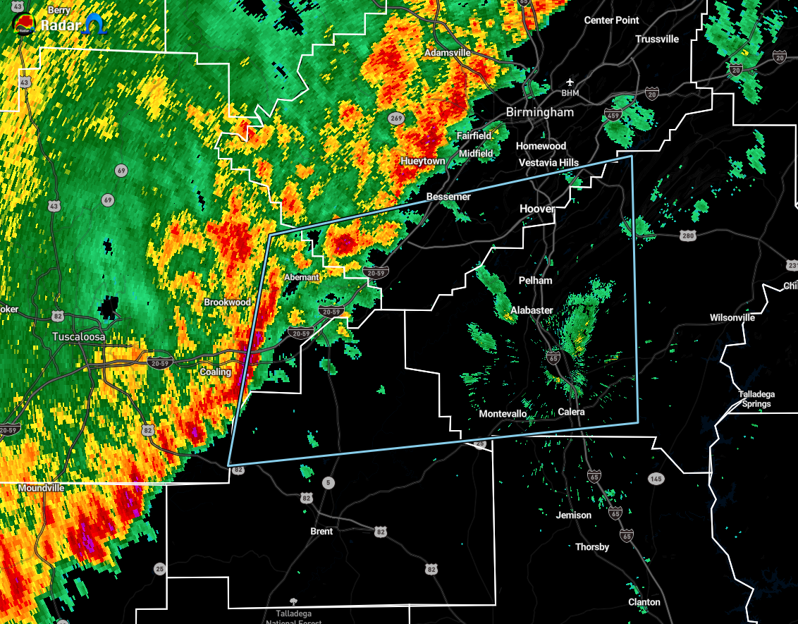
…SIGNIFICANT WEATHER ADVISORY FOR SOUTHEASTERN TUSCALOOSA…WESTERN
SHELBY…NORTHERN BIBB AND SOUTHERN JEFFERSON COUNTIES UNTIL NOON
CST…
At 1116 AM CST, Doppler radar was tracking a cluster of strong
thunderstorms near Mercedes Benz Of Alabama, or 15 miles east of
Holt, moving east at 50 mph.
Winds in excess of 40 mph will be possible with these storms.
Locations impacted include…
Southwestern Birmingham, Hoover, Vestavia Hills, Alabaster, Bessemer,
Pelham, Helena, Calera, Chelsea, Montevallo, Indian Springs Village,
Lake View, Vance, Woodstock, West Blocton, Wilton, North Johns,
American Village, Oak Mountain State Park and Maylene.
These storms may intensify, so be certain to monitor local radio
stations and available television stations for additional
information and possible warnings from the National Weather Service.
Category: Alabama's Weather, ALL POSTS, Severe Weather
About the Author (Author Profile)
Scott Martin is an operational meteorologist, professional graphic artist, musician, husband, and father. Not only is Scott a member of the National Weather Association, but he is also the Central Alabama Chapter of the NWA president. Scott is also the co-founder of Racecast Weather, which provides forecasts for many racing series across the USA. He also supplies forecasts for the BassMaster Elite Series events including the BassMaster Classic.Subscribe
If you enjoyed this article, subscribe to receive more just like it.


