

Weather Xtreme: Nice Saturday, Rain & Storms on Sunday, Cold Start to the Work Week
THE CENTRAL ALABAMA WEEKEND
Skies will begin to clear out somewhat on Saturday from the showers that moved through much of Central Alabama on Friday and Friday night. A Few showers may linger along and south of the I-85 corridor for a bit during the morning, but all of Central Alabama will be dry before the midday hours. No rain is expected for the afternoon hours which includes the Alabama/Auburn game. Afternoon highs will be in the upper 50s to the upper 60s from northwest to southeast. Clouds roll back in late ahead of the next system late and lows will be in the lower 40s to the upper 50s across the area.
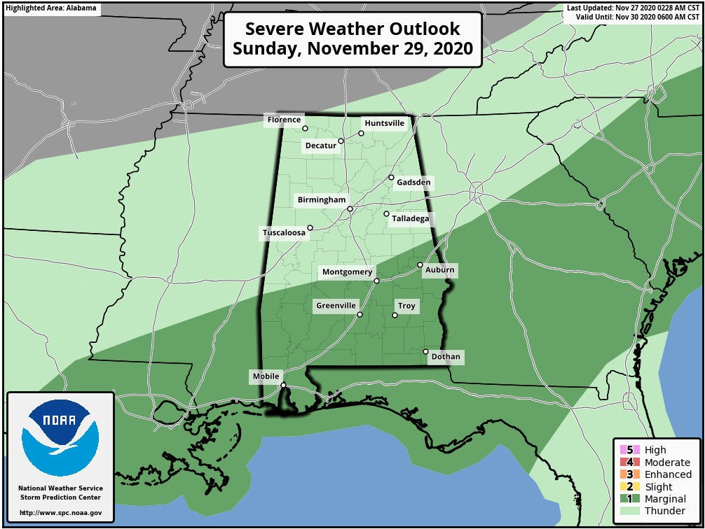
The first half of your Sunday will mainly be dry, but showers and thunderstorms will begin to move into the area from southwest to northeast starting around the midday hour. The northern half of the state will just see rather typical cold front rain and storms while the southern half may have a strong storm or two moves through. SPC has a level 1 Marginal Risk for severe storms for locations south of a line from Linden to Selma to just north of Wetumpka to just north of LaFayette. There is a very small potential for isolated damaging wind gusts and a brief tornado mainly from 12:00 pm to 10:00 pm. Rain will end from west to east during the overnight hours and much colder air will begin to move in. Highs will be in the upper 50s to the upper 60s across the area with overnight lows dropping into the upper 30s to the upper 40s.
MUCH COOLER FOR THE WORK WEEK
The main axis of the very deep trough will move through Central Alabama on Monday that will continue the flow of much colder air into the area and the potential for a few flurries in the extreme northern parts of the area and into North Alabama. Daytime highs may reach the lower 40s to the lower 50s early on, but will be dropping into the mid to upper 30s around or just after 6:00 pm and into the upper 20 to the lower 30s by midnight. Overnight lows will range from the lower 20s in the northwest to the upper 20s in the southeast. You know the drill… bring those pets and sensitive plants indoors, and take precautions with any other sensitive vegetation.
Tuesday and Wednesday will be uneventful weather days across Central Alabama with mornings starting off very chilly and afternoons staying rather cool. Tuesday’s highs will be in the mid to upper 40s across the area and warming up into the lower to mid-50s for “Hump Day.”
Moisture tries to make a return to Central Alabama for your Thursday and Friday and a brief shower may occur over portions of the area on Thursday. Shower chances may be a little higher on Friday as another trough axis will be digging through the northern half of the state, but all moisture looks to be out of here by Friday night. Thursday’s highs will be in the upper 40s to the upper 50s and in the upper 40s to the mid-50s on Friday.
THE TROPICS
We have two disturbances out there in the Atlantic, but the Caribbean and the Gulf of Mexico remains quiet as we are quickly closing in on the end of the 2020 Atlantic Hurricane Season.
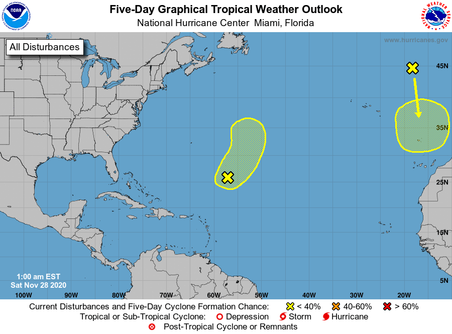
A non-tropical low pressure system located about 600 miles southeast of Bermuda is producing disorganized showers and thunderstorms, mainly to the north and east of the center. Environmental conditions are expected to be only marginally conducive for development this weekend as the low moves northeastward ahead of an approaching frontal system. By early next week, the system is expected to become absorbed by this frontal system over the north-central Atlantic. This system is only given a 30% chance of developing into a tropical or subtropical cyclone within the next five days.
A non-tropical low pressure system has formed over the far eastern Atlantic. This system is expected to move southward about midway between Portugal and the Azores over the weekend. Environmental conditions are forecast to be marginally conducive for the low to acquire subtropical characteristics early next week while it meanders just to the north of the Canary Islands. This system is only given a 30% chance of developing into a tropical or subtropical cyclone within the next five days.
ON THIS DATE IN WEATHER HISTORY
1950: A moderately severe freeze occurred in Florida. The temperature at Tallahassee dropped to 20 degrees, establishing a record for November.
BEACH FORECAST CENTER
Get the latest weather and rip current forecasts for the beaches from Dauphin Island, AL, to Panama City Beach, FL, on our Beach Forecast Center page. There, you can select the forecast of the region that you are interested in.
ADVERTISE ON THE BLOG!
We had another fantastic year in 2019 with just over 17 million page views! That brings our total for the last two years close to 37 million page views! At this point, we are already close to eclipsing the 2019 total. Don’t miss out! We can customize a creative, flexible, and affordable package that will suit your organization’s needs. Contact Bill Murray at (205) 687-0782.
E-FORECAST
Get the Alabama Wx Weather Blog’s Seven-Day Forecast delivered directly to your inbox by email twice daily. It is the most detailed weather forecast available in Central Alabama. Subscribe here… It’s free!
CONNECT WITH THE BLOG ON SOCIAL MEDIA
You can find the AlabamaWx Weather Blog on the major social media networks:
Facebook
Twitter
WEATHERBRAINS
There are several ways to watch or listen to the podcast that is all about the weather. Watch live starting at 8:00 pm CT on Monday nights at live.bigbrainsmedia.com, James Spann’s YouTube Channel, or on one of ABC 3340’s digital weather channels (17.2, 40.2, 68.3). Listen to the recorded audio podcast at WeatherBrains.com or on your favorite podcast platform (Apple Podcasts, Stitcher, Spotify, etc.), or watch the recorded video on James Spann’s YouTube channel.
Category: Alabama's Weather, ALL POSTS, Severe Weather, Tropical, Weather Xtreme Videos
About the Author (Author Profile)
Scott Martin is an operational meteorologist, professional graphic artist, musician, husband, and father. Not only is Scott a member of the National Weather Association, but he is also the Central Alabama Chapter of the NWA president. Scott is also the co-founder of Racecast Weather, which provides forecasts for many racing series across the USA. He also supplies forecasts for the BassMaster Elite Series events including the BassMaster Classic.Subscribe
If you enjoyed this article, subscribe to receive more just like it.


