

A Rather Nice Iron Bowl Midday In Central Alabama, Even With Some Cloud Cover

As of 12:15 pm on your Iron Bowl Saturday, clouds have moved back in over Central Alabama and up into North Alabama blocking out much of the sunshine. At this point, there is no shower activity showing up on radar and it should stay that way through the remainder of the day. Temperatures as of the 12 pm roundup were in the 60s across the area except for a 49-degree reading from Haleyville, but I believe that may be some old data. Tuscaloosa was at 62 degrees. Birmingham was at 61 degrees. The warm spot was Eufaula at 67 degrees. The cool spot, other than the Haleyville reading, was Bessemer at 60 degrees.
Skies will continue to be partly to mostly cloudy across the area throughout the daylight hours and no rain is expected. Afternoon highs will be in the upper 50s to right around 70 degrees from northwest to southeast. Clouds roll back in late ahead of the next system late and lows will be in the lower 40s to the upper 50s across the area. A few showers may be possible in the extreme southwestern parts of the area before sunrise.
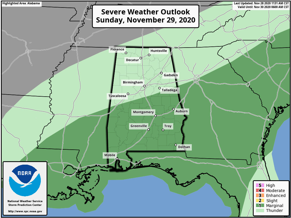
Showers and a few thunderstorms will start to move into the area from the southwest starting on Sunday morning and will eventually affect most, if not all, of Central Alabama by the early afternoon hours. The latest run of the NAM is keeping instability values rather low and well confined to the southern half of the area. A strong to briefly severe storm may be possible with gusty winds and a very small risk of a brief tornado. SPC has a level 1 Marginal Risk for severe storms for locations south of a line from Eutaw to Calera to Lineville. The main timing for the threat of strong to severe storms looks to be from 12:00 pm to 10:00 pm. Rain will end from southwest to northeast during the overnight hours and much colder air will begin to move in. A few lingering showers may persist into the pre-dawn hours on Monday in the extreme northeastern parts of the area. Highs will be in the upper 50s to the mid-60s across the area with overnight lows dropping into the upper 30s to the upper 40s.
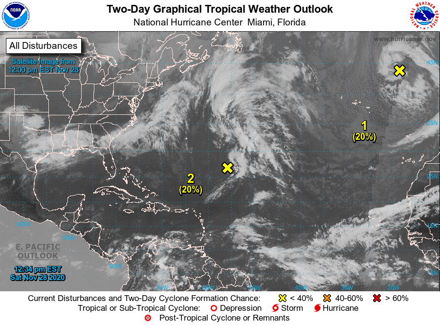
We have two disturbances out there in the Atlantic, but the Caribbean and the Gulf of Mexico remains quiet as we are quickly closing in on the end of the 2020 Atlantic Hurricane Season.
A strong, non-tropical low pressure system over the far eastern Atlantic is expected to move southward about midway between Portugal and the Azores through the weekend. Environmental conditions could allow the low to acquire subtropical characteristics early next week while it meanders just to the north of the Canary Islands. By the middle of next week, environmental conditions are forecast to become unfavorable for further development. This system is only given a 30% chance of developing into a tropical or subtropical cyclone within the next five days.
Recent satellite-derived wind data indicate that the non-tropical low pressure area located over 650 miles east-southeast of Bermuda has opened up into a surface trough. Development of this system appears increasingly unlikely before it is absorbed by another non-tropical low pressure system to its north on Sunday and eventually merges with an approaching frontal system over the north-central Atlantic early next week. This system is only given a 20% chance of developing into a tropical or subtropical cyclone within the next five days.
Category: Alabama's Weather, ALL POSTS, Severe Weather, Tropical
About the Author (Author Profile)
Scott Martin is an operational meteorologist, professional graphic artist, musician, husband, and father. Not only is Scott a member of the National Weather Association, but he is also the Central Alabama Chapter of the NWA president. Scott is also the co-founder of Racecast Weather, which provides forecasts for many racing series across the USA. He also supplies forecasts for the BassMaster Elite Series events including the BassMaster Classic.Subscribe
If you enjoyed this article, subscribe to receive more just like it.


