

Sunny Today; Rain Returns Friday
VERY COLD START: This is the coldest morning so far this season for most Alabama communities. Here are some temperatures just before daybreak…
Black Creek 17
Oneonta 18
Gadsden 19
Fort Payne 19
Meridianville 19
Haleyville 20
Carbon Hill 20
Weaver 20
Hueytown 21
Anniston 21
Cullman 21
Remlap 21
Scottsboro 21
Pell City 21
Huntsville 22
Good Hope 22
Heflin 22
Grayson Valley 22
Talladega 23
Muscle Shoals 24
Bessemer 24
Alabaster 24
Tuscaloosa 25
Montgomery 25
Birmingham 26
Evergreen 27
Mobile 30
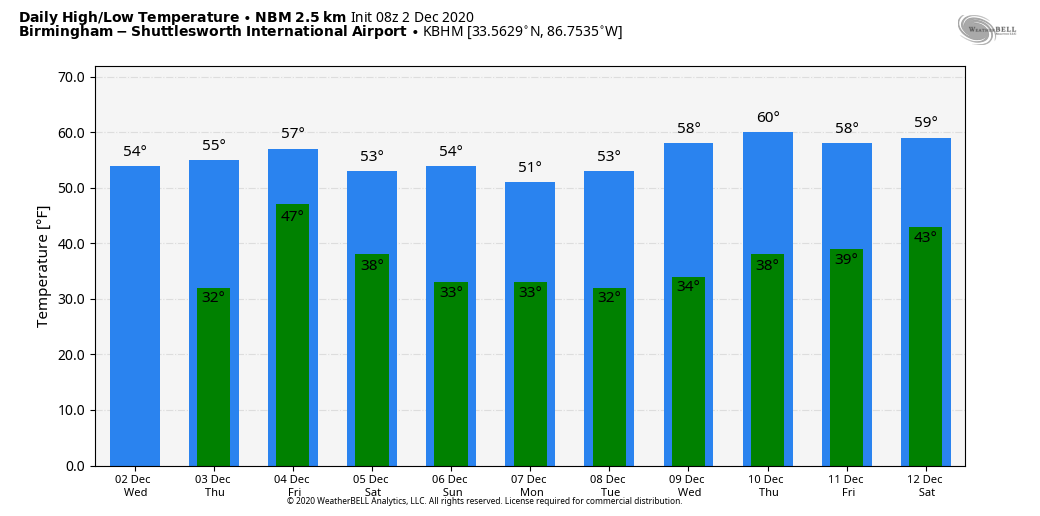
No record for Birmingham; the record low today is 20 set in 1960. But you certainly don’t see lows in the teens that often here in early December. On the positive side, a warming trend begins this afternoon with a sunny sky; the high today will be in the mid 50s.
RAIN RETURNS: Clouds gradually increase tomorrow, but the day should be dry with a high in the 55-59 degree range. An upper low to the west will push rain into the state late tomorrow night and Friday. Models have trended a little slower with the system; it now looks like most of the rain will come from midnight tomorrow night through 6:00 p.m. Friday. Although there might be a rumble of thunder somewhere, no severe weather is expected, and rain amounts should average around 1/2 inch. Temperatures will hold in the 50s all day Friday.
THE ALABAMA WEEKEND: The weekend will be rain-free. The sky becomes partly sunny Saturday, and we expect a good supply of sunshine Sunday. The high Saturday will be in the mid 50s, and not far from 60 Sunday afternoon.
NEXT WEEK: A new surge of cooler air drops into the state Monday; the sky will be partly sunny with a high between 48 and 52. The rest of the week will be cool and dry with highs in the 50s and lows in the 30s… See the Weather Xtreme video for maps, graphics, and more details.
ON THIS DATE IN 1896: Early season snow and ice storm struck the southeastern U.S. Eleven inches of snow fell at Charlotte, NC, and 6 inches at Atlanta, GA.
ON THIS DATE IN 1959: Between November 19 and December 2, an estimated 20 inches of rain fell near Frejus on the French Riviera. The rain caused the Malpasset Dam to collapse, which sent a 130-foot high wall of water into the towns of Malpasset and Bozon. The wall of water 10 feet tall reached Freju
BEACH FORECAST: Click here to see the AlabamaWx Beach Forecast Center page.
WEATHER BRAINS: Don’t forget you can listen to our weekly 90 minute show anytime on your favorite podcast app. This is the show all about weather featuring many familiar voices, including our meteorologists here at ABC 33/40.
CONNECT: You can find me on all of the major social networks…
Look for the next Weather Xtreme video here by 4:00 this afternoon… enjoy the day!
Category: Alabama's Weather, ALL POSTS, Weather Xtreme Videos
About the Author (Author Profile)
James Spann is one of the most recognized and trusted television meteorologists in the industry. He holds the AMS CCM designation and television seals from the AMS and NWA. He is a past winner of the Broadcast Meteorologist of the Year from both professional organizations.Subscribe
If you enjoyed this article, subscribe to receive more just like it.


