

Midday Nowcast: Tons of Sunshine
After the frigid start to the day, we are seeing a nice warm with tons of sunshine across the Alabama landscape today.
The 20s from this morning have been replaced with 40s and 50s this afternoon, overall a great looking final day of the work week.
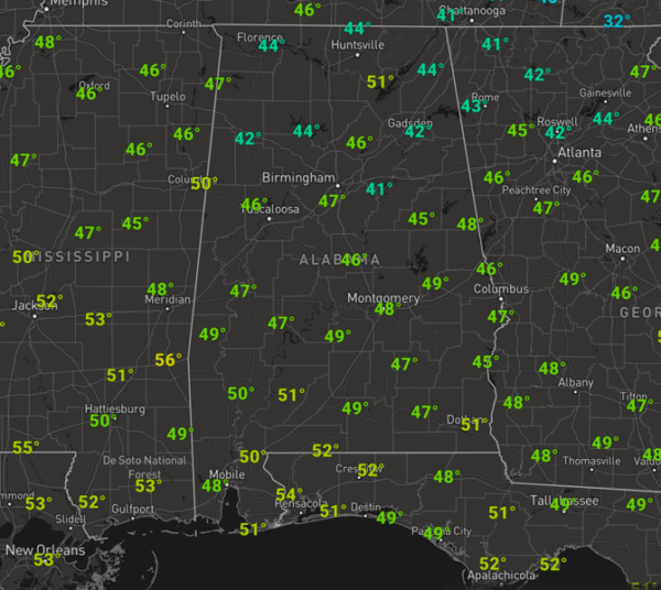
Tonight will be another clear and cold one with mid and upper 20s expected by first thing tomorrow morning.
THE ALABAMA WEEKEND: Clouds return to the state tomorrow, but the day itself will be dry with highs in the mid and upper 50s. Areas of light rain return to the state tomorrow night and into Sunday, with most of the rain shifting into South Alabama during the day Sunday. Again, the surface low with this system will be to the south of the area, so no severe storms, and likely no thunder. Rain amounts should be under 1/2 inch. Highs Sunday will be in the mid to upper 50s.
BEACH FORECAST CENTER: Get the latest weather and rip current forecasts for the beaches from Fort Morgan to Panama City on our Beach Forecast Center page. There, you can select the forecast of the region that you are interested in visiting.
WORLD TEMPERATURE EXTREMES: Over the last 24 hours, the highest observation outside the U.S. was 110.7F at Longreach Airport, Australia. The lowest observation was -65.4F at Yurty, Russia.
CONTIGUOUS TEMPERATURE EXTREMES: Over the last 24 hours, the highest observation was 86F at Big Piney Key, FL. The lowest observation was -11F at Saranac Lake, NY.
WEATHER ON THIS DATE IN 1983: Record cold hit the north central states. At Havre, MT, the mercury plunged to a record reading of 34 degrees below zero.
Category: Alabama's Weather, ALL POSTS
About the Author (Author Profile)
Macon, Georgia Television Chief Meteorologist, Birmingham native, and long time Contributor on AlabamaWX. Stormchaser. I did not choose Weather, it chose Me. College Football Fanatic. @Ryan_StinnetSubscribe
If you enjoyed this article, subscribe to receive more just like it.


