

5:30 p.m. Alabama Weather Update
Here’s an Alabama Weather Update at 5:30 p.m.:
Showers continue over North Alabama at this hour with a lot of low clouds and a little drizzle over the rest of the area.
Clouds eroded enough over southern Alabama and Mississippi to push temperatures into the 70s. This has allowed instability values to rise to 500 joules/kg over the southern third of Alabama and Mississippi. CAPE values over Louisiana are higher.
A tornado watch is in effect for much of southern and Southwest Louisiana until 9 p.m. There has been some discussion about whether a tornado watch will be needed later over southern Mississippi as well.
The surface low is north of Houston at this hour. A maritime warm front lies across southern Mississippi and Alabama, separating the dewpoints that are 65F are higher to the south from the slightly cooler and drier air to the north. The continental warm front is over Northwest Alabama, with dewpoints in the 40s to the northwest of it.
Heavy showers are moving northeastward across southern Mississippi. There is some lightning near the Mississippi River, but not much yet. There is a concentration of lightning in northeastern Louisiana near Monroe. All of this activity will push into southwestern Alabama this evening, but the instability will remain south of US-80 through midnight. There will be some elevated instability, so you may hear some thunder in Central Alabama during the evening. But severe weather will not be likely.
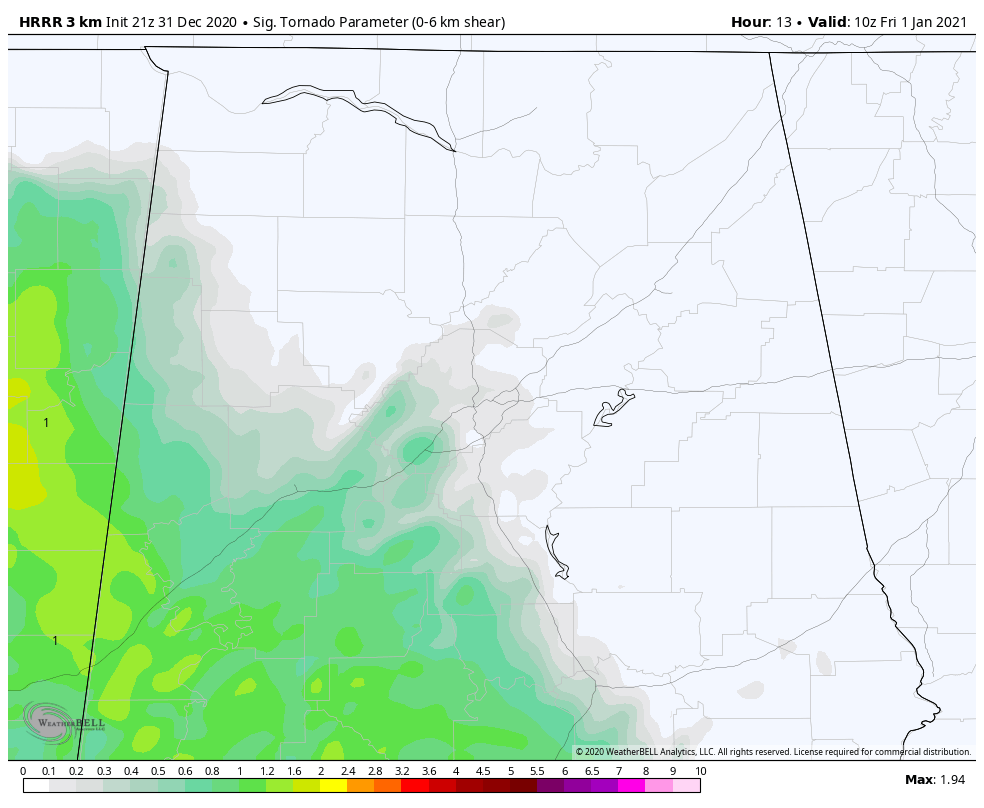
HRRR Significant Tornado Parameter at 4 a.m. Values in green show areas of tornado potential. Values over 1 show a higher potential for significant tornadoes.
As the low moves north, a strong low-level jet will develop, and instability edge northward after midnight. Prefrontal thunderstorm activity will work into Central Alabama after midnight. By 2-3 a.m., there will be sufficient instability and shear for a threat of severe weather over West Central Alabama, with a low-end tornado threat south of Tuscaloosa and west of Montgomery. This threat will work eastward through sunrise with the main threat east of I-65 by 6-7 a.m. Areas in the I-85 Corridor will have to be alert to the tornado threat during the morning hours before noon.
The main threat for damaging winds and tornadoes will be along and south of US-80, but damaging winds and a couple of tornadoes can’t be ruled out over the rest of Central Alabama as well.
We will be monitoring the mesoscale evolution of the system through the evening and will have frequent updates. Just make sure you have a way to receive warnings through the overnight hours that will wake you, just in case.
Here e
Category: Alabama's Weather, ALL POSTS, Severe Weather
About the Author (Author Profile)
Bill Murray is the President of The Weather Factory. He is the site's official weather historian and a weekend forecaster. He also anchors the site's severe weather coverage. Bill Murray is the proud holder of National Weather Association Digital Seal #0001 @wxhistorianSubscribe
If you enjoyed this article, subscribe to receive more just like it.


