

SPC Releases New Mesoscale Discussion… Severe Threat For At Least a Couple More Hours
Latest Mesoscale Discussion from the SPC:
The severe weather threat for Tornado Watch 4 continues.
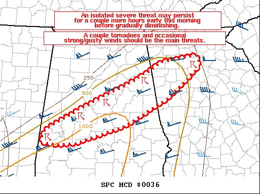
SUMMARY… An isolated severe threat may persist for a couple more hours early this morning before gradually diminishing. A couple of tornadoes and occasional strong/gusty winds should be the main threats.
DISCUSSION…Recent radar imagery shows a broken line of storms extending northeast to southwest across northwestern GA and central AL. The low-level flow across this region should have a tendency to gradually veer to a more southwesterly direction and slowly weaken as the strongest portion of a low-level jet advances into the Carolinas over the next few hours. Even so, there should still be enough veering/strengthening of the wind field in low levels (reference 06Z BMX sounding) to support updraft rotation. A couple of tornadoes will remain possible in the short term with storms advancing northeastward within the broken line. Isolated strong/gusty winds producing occasional damage may also occur with any cell that can acquire a small bowing structure. Current expectations are for this isolated severe threat to gradually diminish later this morning as the low-level flow becomes increasingly parallel to the ongoing convection, which should reduce 0-1 km SRH. The marginal thermodynamic environment across west-central into northern GA should also limit the eastward extent of any meaningful severe risk.
Category: Alabama's Weather, ALL POSTS, Severe Weather
About the Author (Author Profile)
Scott Martin is an operational meteorologist, professional graphic artist, musician, husband, and father. Not only is Scott a member of the National Weather Association, but he is also the Central Alabama Chapter of the NWA president. Scott is also the co-founder of Racecast Weather, which provides forecasts for many racing series across the USA. He also supplies forecasts for the BassMaster Elite Series events including the BassMaster Classic.Subscribe
If you enjoyed this article, subscribe to receive more just like it.


